A Calculation Method of Spaceborne SAR Real-time Imaging Parameters Suitable for Ship Guidance Imaging

A technology of real-time imaging and parameter calculation, applied in ship traffic control, using re-radiation, satellite radio beacon positioning system, etc., can solve the problems of difficult remote sensing information data real-time data, fusion, unfavorable user use, etc., to achieve better The effect of ease of use, improved timeliness and visibility, and simplified mission planning process for terrestrial SAR imaging

Active Publication Date: 2022-04-08
BEIJING INST OF SPACECRAFT SYST ENG
View PDF7 Cites 0 Cited by
  • Summary
  • Abstract
  • Description
  • Claims
  • Application Information

AI Technical Summary

Problems solved by technology

However, the current imaging process of satellite SAR payload usually requires the user to analyze the ship message data downloaded by the AIS payload in advance, determine the area where the target ship is located, give the SAR imaging task plan one day in advance, and generate the SAR imaging command package. After the satellite enters the country, The domestic ground control center sends the command packet to the satellite, and then the microwave imaging can only be completed when the satellite revisits the area where the target ship is located. Therefore, it is actually difficult to achieve real-time data fusion of the remote sensing information data of the above two loads, which is not conducive to user use

Method used


Image

  • A Calculation Method of Spaceborne SAR Real-time Imaging Parameters Suitable for Ship Guidance Imaging
  • A Calculation Method of Spaceborne SAR Real-time Imaging Parameters Suitable for Ship Guidance Imaging
  • A Calculation Method of Spaceborne SAR Real-time Imaging Parameters Suitable for Ship Guidance Imaging

Examples


Embodiment Construction

[0054] The present invention will be further elaborated below in conjunction with embodiment.

[0055] The calculation method of space-borne SAR real-time imaging parameters provided by the present invention can be adapted to general survey imaging in fixed sea areas, and only needs to be packaged on the ground to fill in the imaging requirements at one time, so that the on-board digital tube can independently complete the real-time imaging parameter calculation of SAR satellites on-orbit , so that the satellite can automatically generate a series of imaging instructions, and independently complete the batch imaging tasks of the census and monitoring of fixed sea areas during this period, thereby improving the ease of use of the satellite.

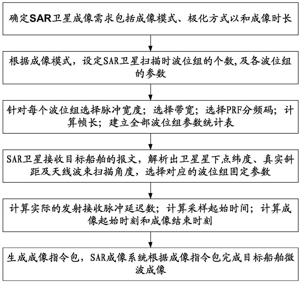
[0056] Such as figure 1 As shown, the calculation method of spaceborne SAR real-time imaging parameters specifically includes the following steps:

[0057] Step 1. Determine the SAR satellite imaging requirements including imaging mode, p...


PUM


Abstract

The invention relates to a method for calculating space-borne SAR real-time imaging parameters suitable for ship-guided imaging, belonging to the technical field of autonomous imaging of low-orbit SAR payload satellites; Step 1, determining the imaging mode, polarization mode and imaging duration of the SAR satellite; Step 2 , setting the number of wave position groups, and the parameters of each wave position group; step 3, selecting the pulse width, bandwidth and PRF frequency division code of each wave position group; calculating the frame length; step 4, analyzing the target ship message to obtain The latitude of the sub-satellite point, the real slant distance and the scanning angle of the antenna beam, select the corresponding fixed parameters of the wave position group; Step 5, calculate the actual number of transmit and receive pulse delays, sampling start time, imaging start time and imaging end time; Step 6: The SAR imaging system completes the microwave imaging of the target ship according to the imaging instruction package; the present invention realizes the real-time SAR imaging within a short period of time (shortened to seconds) when the AIS finds the target ship, and greatly improves the timeliness of marine ship monitoring sex and visibility.

Description

technical field [0001] The invention belongs to the technical field of autonomous imaging of low-orbit SAR payload satellites, and relates to a calculation method for space-borne SAR real-time imaging parameters suitable for ship-guided imaging. Background technique [0002] my country is a big country with a marine territory of more than 3 million square kilometers and rich marine resources. Due to the large number of ports, complex waterways, and changing sea conditions, efficient and accurate ship detection methods are urgently needed to complete tasks such as warship discovery and positioning, sea area ship monitoring, fishing boat monitoring, and ship rescue in distress. Synthetic aperture radar satellites (hereinafter referred to as SAR satellites) have all-weather, all-weather, and large-scale observation capabilities, and can observe the ocean in a macro, long-term, dynamic, and real-time manner. means. [0003] In addition, in order to assist SAR satellites to mon...

Claims


Application Information

Patent Timeline
Patent Type & Authority Patents(China)
IPC IPC(8): G01S13/90G01S13/91G01S13/937G01S19/48G08G3/02
CPCG01S13/90G01S13/91G01S19/48G08G3/02
Inventor 赵良波周丽萍张庆君刘杰张弛王涛赵峭张磊
Owner BEIJING INST OF SPACECRAFT SYST ENG
Why Eureka
Try Eureka