Mine goaf monitoring and early warning system and method based on WebGIS
A technology for monitoring and early warning and gobs, applied in transmission systems, alarms, measuring devices, etc., can solve problems such as inability to prevent disasters before they happen, and achieve the effect of avoiding losses and improving reliability
- Summary
- Abstract
- Description
- Claims
- Application Information
AI Technical Summary
Problems solved by technology
Method used
Image

Examples
Embodiment 1
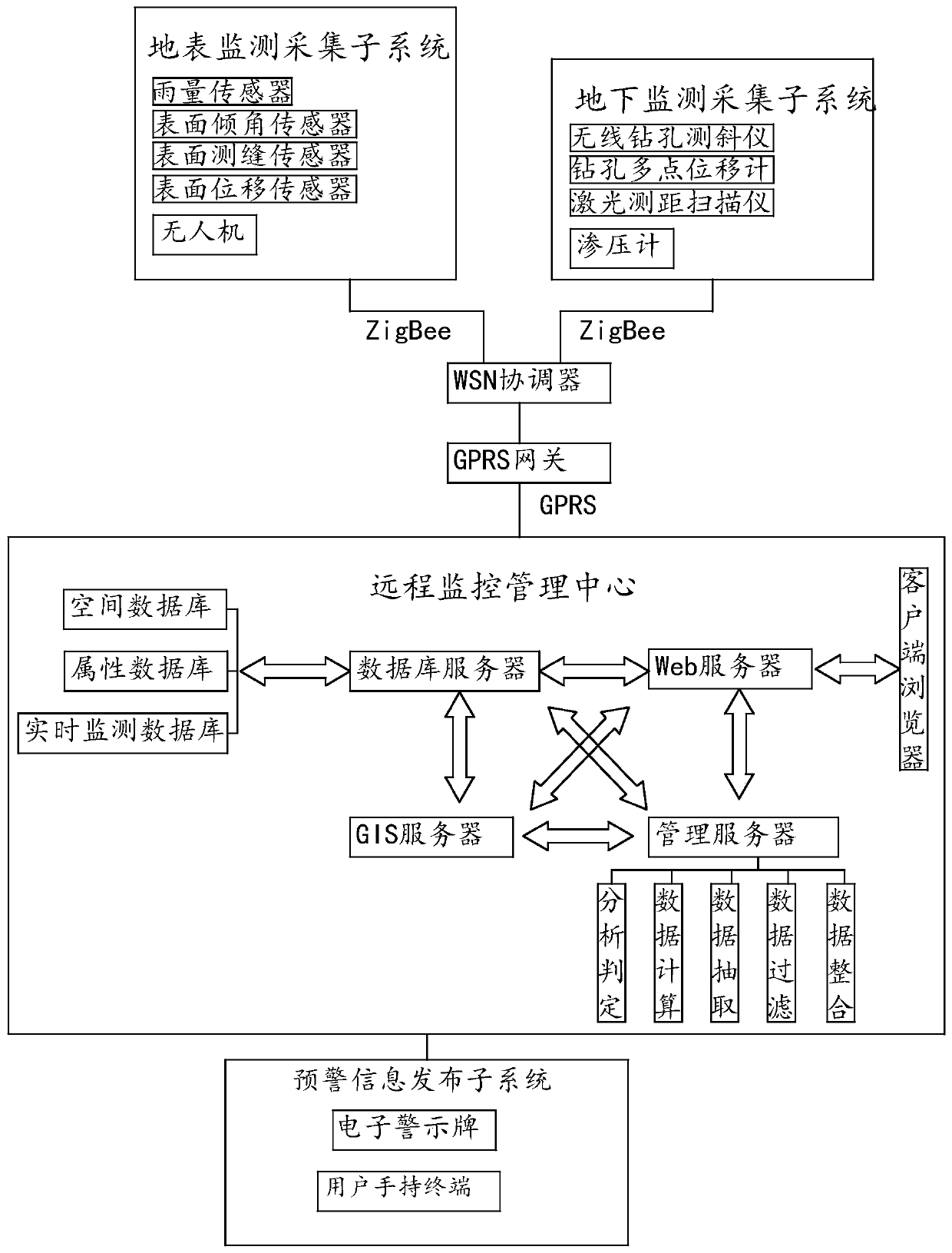
[0022] Please refer to the attached figure 1 As shown, the present invention provides a mine goaf monitoring and early warning system based on WebGIS, including surface monitoring and acquisition subsystem, underground monitoring and acquisition subsystem, WSN coordinator, GPRS gateway, remote monitoring management center, early warning information release subsystem, The surface monitoring and collection subsystem and the underground monitoring and collection subsystem monitor and collect goaf surface information and underground information in real time respectively, and transmit the collected data information to the WSN coordinator through the wireless communication network, and the WSN coordinator communicates with the remote monitoring through the GPRS gateway The management center is connected by communication, and the remote monitoring management center stores, analyzes, manages and processes the information data and releases the early warning information through the early...
Embodiment 2
[0033] A kind of mine goaf monitoring and early warning method based on WebGIS provided by the present invention comprises:
[0034] (1) A number of surface monitoring nodes are arranged on the ground in the goaf of the mine, and a number of underground monitoring nodes are arranged in the underground overlying strata and goafs of the goaf to form a wireless sensor star topology network, and connect the WSN coordinator, GPRS gateway and remote monitoring through the wireless network The upper computer of the management center; build a database, collect and store the geographical information, geological information, and disaster information of the historical records of the mine goaf through the database, sort out and analyze the information data, obtain the safety risk information data, and classify the types and levels of early warning; The types of early warning include surface subsidence, ground subsidence, ground fissures, landslides, and debris flows. The early warning leve...
PUM
 Abstract
Description
Claims
Application Information