Method for measuring mine topographic map through RTK linear lofting measurement

A topographic map and straight line technology, applied in mine topographic map measurement, RTK line stakeout measurement in the field of mine topographic map measurement, can solve problems such as missed mining and uneven mining points in the field, so as to improve speed and quality, and improve overall efficiency and quality effects

Inactive Publication Date: 2020-07-31
河南省焦作地质勘察设计有限公司
View PDF6 Cites 0 Cited by
  • Summary
  • Abstract
  • Description
  • Claims
  • Application Information

AI Technical Summary

Problems solved by technology

[0003] The purpose of the present invention is to provide a kind of RTK linear stakeout measurement method in mine topographic map measurement in order to solve the above-mentioned problem, has realized that RTK linear stakeout measurement technology is applied to mine topographic survey, effectively solves mine topographic map measurement due to various reasons The problems of uneven mining points and missed mining formed in the field can improve the comprehensive efficiency and quality of field mining points in mine topographic map measurement, and improve the speed and quality of topographic map mapping

Method used


Image

  • Method for measuring mine topographic map through RTK linear lofting measurement

Examples


Embodiment

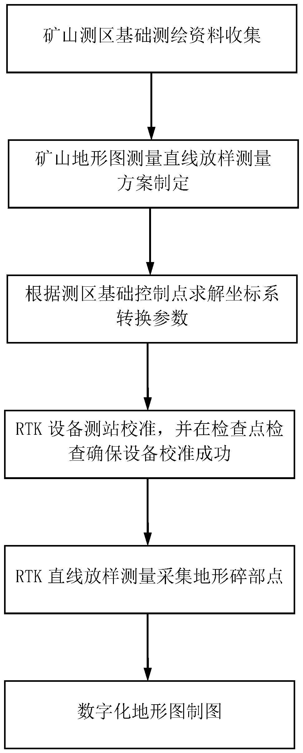
[0036] This embodiment is an example of implementing conventional 1:1000 topographic map surveying and mapping by using RTK linear stakeout measurement in mine topographic map measurement method.

[0037] The concrete realization of this embodiment is described in detail below:

[0038] (1) Collect the basic surveying and mapping data of the mine survey area, including the basic control points of the survey area, existing topographic maps, image maps, etc. (Google Earth can be used to obtain survey area images and general topographic data);

[0039] (2) Formulate a mine topographic map measurement line stakeout measurement plan, design a number of line measurement routes in advance, and determine the appropriate route direction and spacing. According to the direction of the mining area and the topography, determine the direction of the route. Generally, the direction can be parallel to the mountain ridges and ravines to reduce the physical exertion of the surveying and mapping...


PUM


Abstract

The invention discloses a method for measuring a mine topographic map through RTK linear lofting measurement. According to the method, a plurality of linear measurement routes are designed in advanceaccording to the mapping requirements of a mine topographic map and the general topography of a measurement area, proper route directions and intervals are determined, and then measurement is conducted along the designed measurement routes in an RTK linear lofting mode according to topographic relief changes. Surveying and mapping personnel in mine survey areas with complex mountain heights, forest densities and terrains are easy to lose directions, so that landform points are collected too densely or too sparsely, even large-area missing point areas occur, rework is inevitably caused, the effective operation efficiency and quality are reduced, and time, manpower and material resources are wasted. The method can effectively solve the problems of non-uniform field mining points and missingmining caused by various reasons in mine topographic map measurement, improves the comprehensive efficiency and quality of the field mining points in the mine topographic map measurement, and improvesthe mapping speed and quality of the topographic map.

Description

technical field [0001] The invention relates to a method for measuring topographic maps of mines, in particular to a method for measuring topographic maps of mines by RTK linear stakeout measurement, and belongs to the technical field of topographic surveying and mapping. Background technique [0002] With the rapid development of science and technology, RTK technology, that is, real-time dynamic measurement technology based on carrier phase, has also been greatly developed, and the successful application of this technology has found the answer to the traditional mine topographic measurement method. In the past, the traditional mine topography There are two measurement methods: the first is the aerial photogrammetry method for large-area terrain; the second is the regional total station digital topographic measurement method. With the continuous advancement of GPS technology, the carrier phase based RTK measurement technology is now widely used in various operations of mine ...

Claims


Application Information

Patent Timeline
IPC IPC(8): G01C7/02
CPCG01C7/02
Inventor 兰进京郝俊柳郭栋王珂陆永红王跃广崔翔汪浩刘记光
Owner 河南省焦作地质勘察设计有限公司
Why Eureka
Try Eureka