Supercharge Your Innovation With Domain-Expert AI Agents!

High-precision real-time micro-nano satellite cluster navigation algorithm

A satellite cluster and navigation algorithm technology, applied in the field of navigation, can solve problems such as less research on kinematic orbit determination methods

Active Publication Date: 2020-08-04
BEIHANG UNIV
View PDF12 Cites 4 Cited by
  • Summary
  • Abstract
  • Description
  • Claims
  • Application Information

AI Technical Summary

Problems solved by technology

However, compared with the reduced dynamics method, the research on the kinematic orbit determination method is less, especially in the field of single-frequency real-time

Method used


Image

  • High-precision real-time micro-nano satellite cluster navigation algorithm
  • High-precision real-time micro-nano satellite cluster navigation algorithm
  • High-precision real-time micro-nano satellite cluster navigation algorithm

Examples


Embodiment Construction

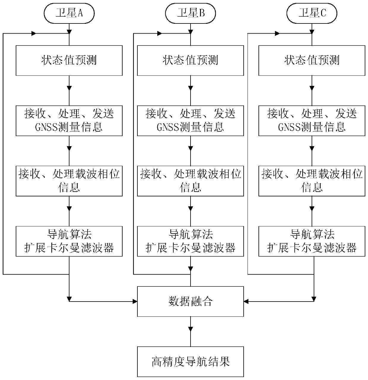
[0083] The following will be attached figure 1 And technical solutions, taking a satellite cluster composed of three stars A, B, and C as an example, the specific implementation process of the present invention will be further described in detail.

[0084] Step 1: Calculate the predicted state of the satellites in the cluster

[0085] Satellite A uses the absolute dynamics model to calculate the state prediction value of its own position and velocity, and uses the relative dynamics model to calculate the state prediction value of the satellites B and C in the cluster.

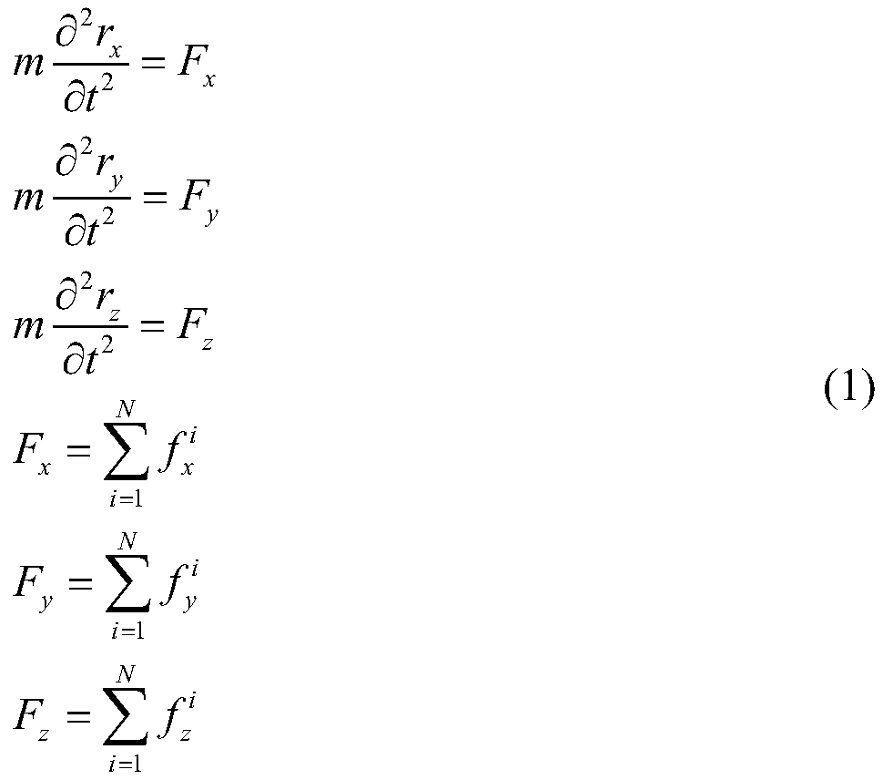
[0086] The resultant force of the forces received by the satellite in space can be decomposed into the three directions of x, y, and z along the coordinate system, denoted as F x ,F y ,F z , So the absolute dynamics equation of the satellite is expressed in vector form:

[0087]

[0088] Where m represents the mass of the entire satellite, and i represents the i-th perturbation force considered in the dynamic model.

[...


PUM


Abstract

The invention provides a micro-nano satellite cluster distributed navigation scheme based on a global navigation satellite system (GNSS) single-frequency receiver. A micro-nano satellite cluster absolute / relative orbit kinetic model suitable for high-precision navigation is constructed, a fusion mechanism of single-frequency combined observation data and carrier phase differential data is established, and then a high-precision micro-nano satellite cluster navigation algorithm is designed. A distributed navigation concept is adopted, that is, each satellite in a cluster can send own GNSS measurement information to other satellites, and each satellite can use the received other satellites and the own GNSS measurement information to navigate all satellites in the cluster. According to a specific implementation method of the invention, Kalman filtering-based correction is performed on estimated quantities of state quantities such as a satellite position, a speed and the like which are calculated by using a kinetic model, by using GNSS observed quantities and relative position vectors obtained based on a carrier difference; and therefore, high-precision absolute and relative position information of the satellite cluster is obtained, and a purpose of high-precision navigation of the satellite cluster is achieved. The algorithm has the advantages of high navigation precision and goodreal-time performance.

Description

Technical field [0001] The present invention provides a micro-nano satellite cluster navigation algorithm with higher accuracy and real-time performance. It relates to a use of GNSS (Global Navigation Satellite System) to broadcast ephemeris, single-frequency pseudorange and carrier phase information, and calculation based on carrier difference The obtained relative position vector between satellites uses the extended Kalman filter to perform high-precision navigation to the satellite cluster. It belongs to the field of navigation technology. Background technique [0002] The GNSS-based precision satellite orbit determination technology can be traced back to the feasibility study of the US Lockheed Missile Company on the application of GPS for spacecraft navigation in 1975. Studies believe that the use of spaceborne GPS receivers for navigation is technically feasible below 800km orbital altitude, and navigation in higher orbits also has huge room for research and development. ...

Claims


Application Information

Patent Timeline
Patent Type & Authority Applications(China)
IPC IPC(8): G01S19/42
CPCG01S19/423
Inventor 孙秀聪耿铖贾振俊陈培
Owner BEIHANG UNIV
Features
  • R&D
  • Intellectual Property
  • Life Sciences
  • Materials
  • Tech Scout
  • Unparalleled Data Quality
  • Higher Quality Content
  • 60% Fewer Hallucinations
Learn More