Preparation method of indoor occupation grid map based on RGB-D information

A technology that occupies grids and maps. It is applied in the direction of specific mathematical models, image enhancement, and image analysis. It can solve the problems of restricting consumer market demand and high cost of lidar, and achieve high practical value and low cost. Effect

Pending Publication Date: 2020-08-28
金华航大北斗应用技术有限公司
View PDF6 Cites 21 Cited by
  • Summary
  • Abstract
  • Description
  • Claims
  • Application Information

AI Technical Summary

Problems solved by technology

[0003] The traditional generation method of indoor occupancy grid map uses multi-line lidar to scan the indoor environment to obtain rich point cloud data. Point cloud is the most direct storage form of indoor structural information representing the state of occupancy grid. High and easy to operate, but due to the high cost of lidar, the demand in the consumer market is limited

Method used


Image

  • Preparation method of indoor occupation grid map based on RGB-D information
  • Preparation method of indoor occupation grid map based on RGB-D information
  • Preparation method of indoor occupation grid map based on RGB-D information

Examples


Embodiment

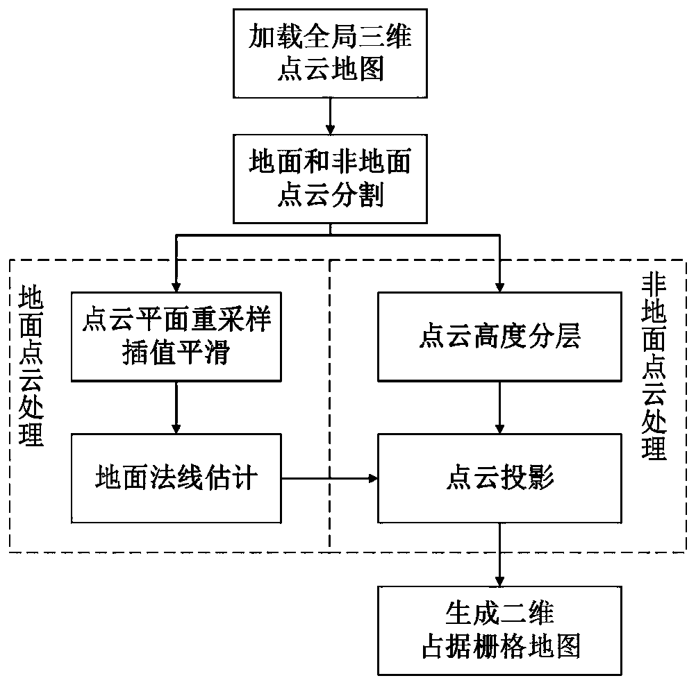
[0027] In the present invention, the global point cloud map is spliced ​​according to the camera pose, and after preprocessing such as downsampling and noise point elimination, the morphological progressive filter algorithm is used to segment the ground point cloud and the non-ground point cloud, and the ground point cloud is smoothed. In order to estimate the normal, the non-ground point cloud at different height levels is projected to a two-dimensional plane and divided into grids, and the occupancy state is updated by Bayesian probability estimation method.

[0028] Such as Figure 1-6 As shown, an embodiment of the present invention provides a method for preparing an indoor occupancy grid map based on RGB-D information, and the preparation method includes the following steps:

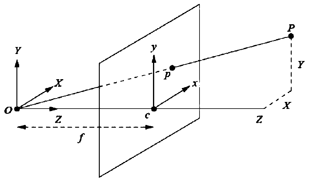
[0029] S1. Use the Kinect camera to simultaneously collect the color image and depth image sequence of the indoor scene. For a single pair of color image and depth image, combine the camera pose, ca...


PUM


Abstract

The invention provides a preparation method of an indoor occupation grid map based on RGB-D information, and relates to the technical field of robot indoor navigation. The preparation method of the indoor occupancy grid map based on the RGB-D information comprises the steps of loading a global three-dimensional point cloud map, performing ground and non-ground point cloud segmentation, performingground and non-ground point cloud processing, generating a two-dimensional occupancy grid map and the like. According to the preparation method, the precision of the prepared indoor map is approximateto that of a laser radar type generation method, and the cost is lower than that of a laser radar, and the practical value is higher; and the generated two-dimensional occupation grid maps with different height levels can meet the navigation requirements of robots with different working heights.

Description

technical field [0001] The invention relates to the technical field of robot indoor navigation, in particular to a method for preparing an indoor occupancy grid map based on RGB-D information. Background technique [0002] Robot maps can be classified in many ways, including scale maps, topological maps, and semantic maps. Among them, the occupancy grid map in the scale map is the most widely used, which can realize key mission requirements such as indoor navigation and obstacle avoidance. By dividing the indoor environment into grids of a certain number and size, based on whether the grid contains indoor structure information or obstacles, it is measured whether the grid is occupied, so that the indoor map can be divided into passable areas and impassable areas. traffic area. [0003] The traditional indoor occupancy grid map generation method uses multi-line lidar to scan the indoor environment to obtain rich point cloud data. Point cloud is the most direct storage form ...

Claims


Application Information

Patent Timeline
Patent Type & Authority Applications(China)
IPC IPC(8): G06T7/136G06T7/155G06T7/55G06T7/80G06T3/40G06T5/00G06T5/30G06N7/00G01C21/20
CPCG06T7/136G06T7/155G06T7/55G06T7/80G06T5/30G06T5/002G06T3/4038G01C21/206G06T2207/10028G06N7/01
Inventor 闫大禹修春娣张井合
Owner 金华航大北斗应用技术有限公司
Why Eureka
Try Eureka