Intelligent sponge city flood forecasting method

A sponge city and intelligent technology, applied in forecasting, complex mathematical operations, instruments, etc., can solve the problems of urban hydrological models lacking input and model verification spatial distribution data, high accuracy requirements, and reduced simulation accuracy

Active Publication Date: 2020-09-11
NANCHANG INST OF TECH +2
View PDF14 Cites 24 Cited by
  • Summary
  • Abstract
  • Description
  • Claims
  • Application Information

AI Technical Summary

Problems solved by technology

Due to the complexity of the city itself, urban runoff and flood simulation models require more information and data, and the accuracy requirements are higher, often exceeding the content and accuracy of conventional hydrological element observations
I

Method used


Image

  • Intelligent sponge city flood forecasting method
  • Intelligent sponge city flood forecasting method
  • Intelligent sponge city flood forecasting method

Examples


Embodiment 1

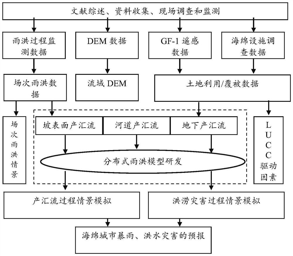
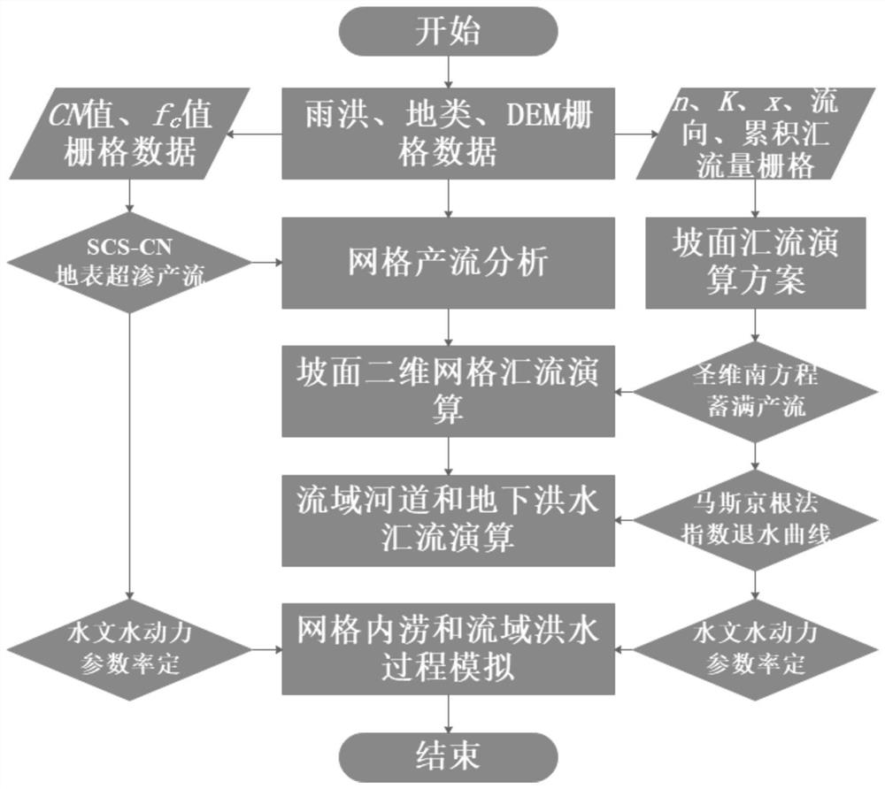
[0078] The present invention provides an intelligent sponge city flood forecasting method, specifically as figure 1 shown, including the following steps:

[0079] Step 1. Construct the planar calculation grid of the study area, specifically including;

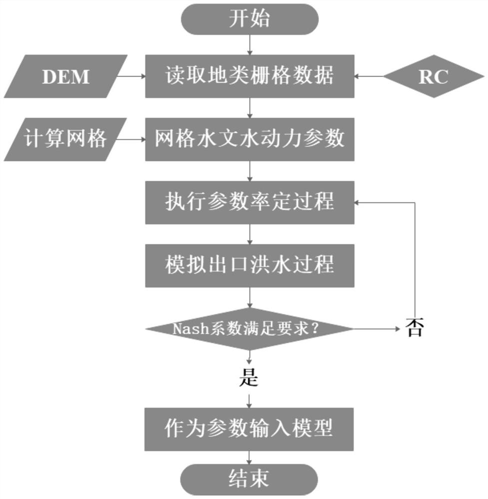
[0080] Obtain the DEM file of the research area, use ArcGIS software to convert the DEM file into an ASCII file, open the .txt file in the ASCII file, read the initial horizontal and vertical coordinates, grid size, and number of grid rows and columns in the header of the file, and use the help of The Java language development integrated environment IntelliJ IDEA and WebGIS perform interactive language compilation, create a grid with the same starting horizontal and vertical coordinates, the same grid size, and the same number of grid rows and columns as the DEM source file, and export the grid data to WebGIS , save the file after running, add the watershed boundary of the research area, and use the mask clipping tool to cut t...

Embodiment 2

[0137] The following describes the specific implementation of Example 1 through the Pingxiang smart sponge city flood forecasting process according to the flow direction of the data flow, including the following operations:

[0138] 1) Selection of study area and construction of grid data:

[0139] In this example, the Wufeng River Basin and its adjacent rivers in Pingxiang City are selected as the research area. According to the spatial resolution of geographic information data and the temporal and spatial scale of flood disasters, the spatial resolution of the grid is selected to be 30m, and the research area is gridded. Based on spatial maps such as digital elevation model (DEM) and land use map, spatial interpolation algorithm is used to obtain spatial geographic information at the grid.

[0140] 2) Identification of the rainstorm process in the Pingxiang research area:

[0141] In this example, based on the excerpt table of hydrological elements of rainstorm and flood of...


PUM


Abstract

The invention provides an intelligent sponge city flood forecasting method, which belongs to the technical field of city management, and comprises the following steps: constructing a research area plane calculation grid; determining a hydrological hydrodynamic time history continuous calculation time interval between the grids; extracting high spatial resolution grid elevation and land utilization/coverage information; assigning values to the grid precipitation time history data; assigning values to the grid production and confluence parameters; taking the grid elevation, the land utilization/coverage information and the rainfall and runoff production and confluence parameters as a model operation database, integrating a hydrological hydrodynamic theory, and constructing a hydrological hydrodynamic model by using the method; verifying the hydrological hydrodynamic model; and based on the simulation result of the hydrological hydrodynamic model, performing basin runoff production and confluence and flood disaster prediction. According to the method, the urban flood problem can be quickly, intelligently and flexibly dealt with by realizing real-time quick forecasting of rain conditions and water conditions, real-time quick forecasting of urban flood, intelligent regulation and control of a water system and refined management.

Description

technical field [0001] The invention belongs to the technical field of urban management, and in particular relates to an intelligent sponge city flood forecasting method. Background technique [0002] The core of sponge city construction is to solve the problem of urban flooding. Urban storm runoff control technical measures are the core of sponge city construction, among which urban flood disaster early warning and forecasting is one of its important non-engineering measures, and storm runoff simulation model is used to calculate and evaluate engineering The impact of improvement or implementation of measures on the law of storm runoff and drainage system will provide scientific data for the implementation of runoff regulation engineering measures. [0003] Usually, the basic data required for the hydrological and hydrodynamic simulation model of urban flood disasters include terrain, soil, land cover / use, rainfall, and other hydrological element monitoring data. Due to th...

Claims


Application Information

Patent Timeline
IPC IPC(8): G06F30/20G06F17/18G06Q10/04G06Q50/26
CPCG06F30/20G06F17/18G06Q10/04G06Q50/26Y02A10/40
Inventor 白桦黄监初冷梦辉黄旭初桂发亮刘永红林世云
Owner NANCHANG INST OF TECH
Why Eureka
Try Eureka