Three-dimensional field display method and device based on GIS system, terminal and storage medium

A display method and three-dimensional technology, applied in the field of geographic information systems, can solve the problems of missing height information, inability to directly apply, inability to compare images, and visually display field model effects, etc., to increase display probability, improve user experience, and improve Show the effect of the effect

Pending Publication Date: 2020-09-18
PINGAN CITY CONSTR TECH SHENZHEN CO LTD
View PDF0 Cites 0 Cited by
  • Summary
  • Abstract
  • Description
  • Claims
  • Application Information

AI Technical Summary

Problems solved by technology

But when the scene is switched to a 3D scene, the data format of the thermal value data changes to {x, y, z, value}, the form of the gradient circle cannot be directly applied, and a flat heat map loses height information and cannot be expressed There is no way to describe the thermal value of a certain point in the space, such as the concentration at an altitude of 100 meters and the concentration at an altitude of 50 meters, so it is impossible to compare the effect of a field model in a three-dimensional space visually and intuitively

Method used


Image

  • Three-dimensional field display method and device based on GIS system, terminal and storage medium
  • Three-dimensional field display method and device based on GIS system, terminal and storage medium
  • Three-dimensional field display method and device based on GIS system, terminal and storage medium

Examples


Embodiment 1

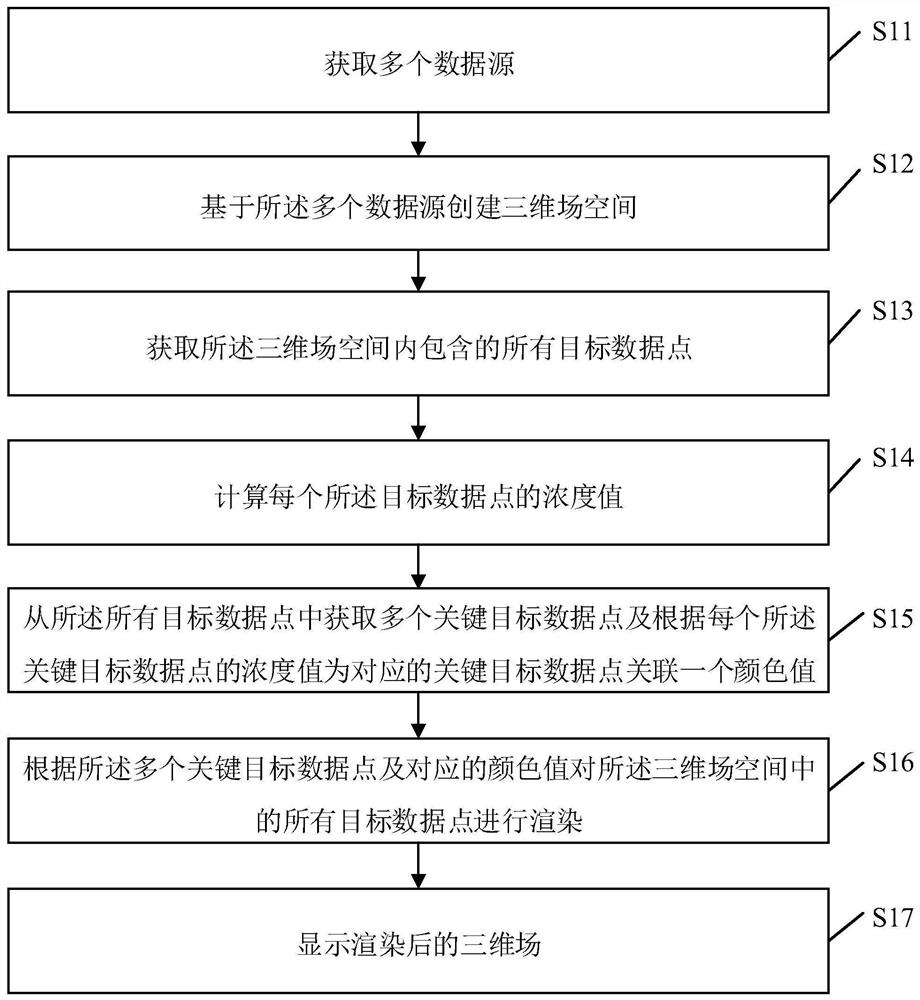
[0051] figure 1 It is a flow chart of the three-dimensional field display method based on the GIS system provided by Embodiment 1 of the present invention.

[0052]In this embodiment, the three-dimensional field display method based on the GIS system can be applied to terminals. For terminals that need to display three-dimensional fields based on the GIS system, the GIS-based field display method provided by the method of the present invention can be directly integrated on the terminal. The function of the three-dimensional field display of the system, or run in the terminal in the form of a software development kit (Software Development Kit, SKD).

[0053] like figure 1 As shown, the GIS system-based three-dimensional field display method specifically includes the following steps. According to different requirements, the order of the steps in the flow chart can be changed, and some of them can be omitted.

[0054] S11: Obtain multiple data sources.

[0055] In this embodim...

Embodiment 2

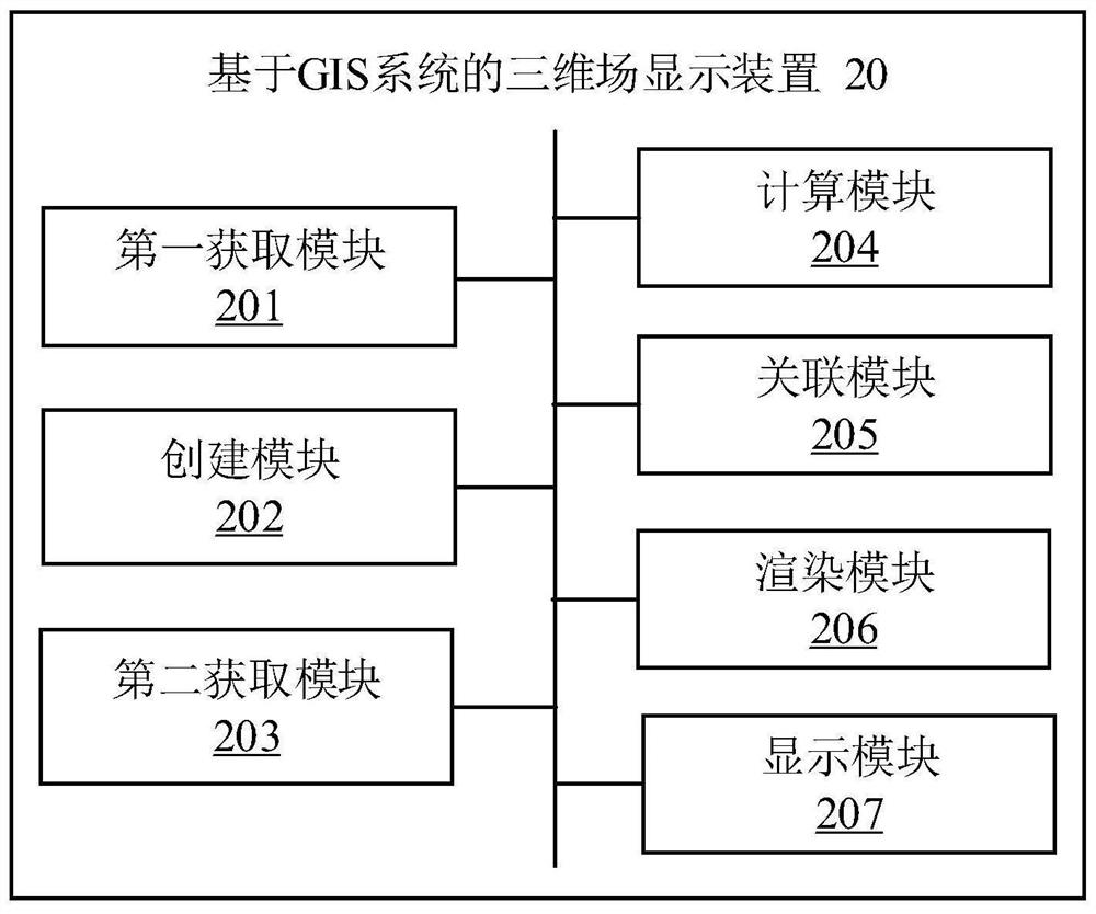
[0109] figure 2 It is a structural diagram of the three-dimensional field display device based on the GIS system provided by the second embodiment of the present invention.

[0110] In some embodiments, the GIS system-based three-dimensional field display device 20 may include a plurality of functional modules composed of program code segments. The program codes of the various program segments in the three-dimensional field display device 20 based on the GIS system can be stored in the memory of the terminal, and executed by the at least one processor to execute (see for details figure 1 Description) to display the 3D field based on the GIS system.

[0111] In this embodiment, the three-dimensional field display device 20 based on the GIS system can be divided into multiple functional modules according to the functions it performs. The functional modules may include: a first acquisition module 201 , a creation module 202 , a second acquisition module 203 , a calculation mod...

Embodiment 3

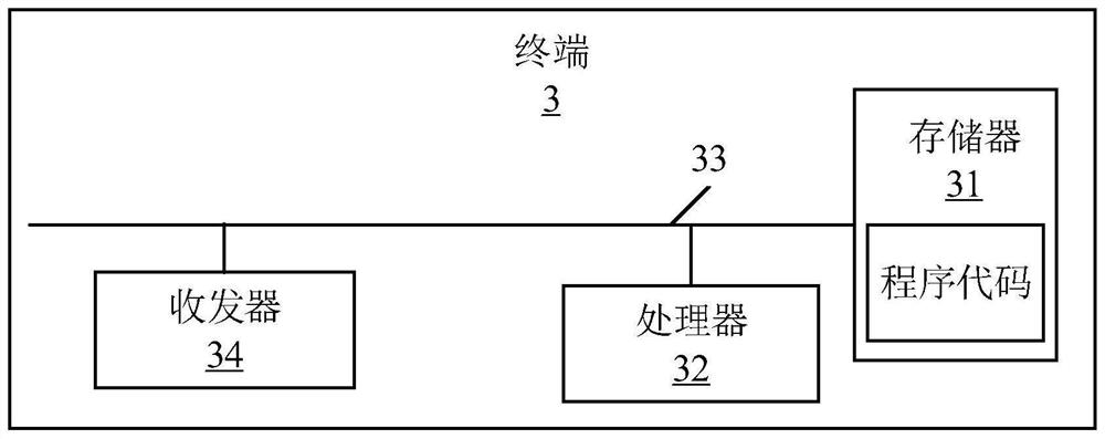
[0166] refer to image 3 As shown in , it is a schematic structural diagram of a terminal provided by Embodiment 3 of the present invention. In a preferred embodiment of the present invention, the terminal 3 includes a memory 31 , at least one processor 32 , at least one communication bus 33 and a transceiver 34 .

[0167] Those skilled in the art should understand that, image 3 The structure of the terminal shown does not constitute a limitation of the embodiment of the present invention, it can be a bus structure or a star structure, and the terminal 3 can also include more or less other hardware or software than shown in the figure , or different component arrangements.

[0168] In some embodiments, the terminal 3 is a terminal capable of automatically performing numerical calculations and / or information processing according to preset or stored instructions, and its hardware includes but not limited to microprocessors, application-specific integrated circuits, programmab...


PUM


Abstract

The invention relates to the technical field of big data. The invention provides a three-dimensional field display method based on a GIS system. The method comprises the steps of obtaining multiple data sources, creating a three-dimensional field space based on the plurality of data sources and obtaining all target data points in the three-dimensional field space, calculating the concentration value of each target data point; obtaining a plurality of key target data points from all the target data points, associating a color value for the corresponding key target data point according to the concentration value of each key target data point, rendering all the target data points in the three-dimensional field space according to the plurality of key target data points and the corresponding color values, and then displaying the three-dimensional field. The invention also relates to a blockchain technology, and the target data point is stored in the blockchain. According to the method, theconcentration value of each target data point in the created three-dimensional field space is calculated, different colors are associated with the concentration values of the key target data points, avisual and vivid field model of the three-dimensional field space is displayed for a user, and the user experience is improved.

Description

technical field [0001] The invention relates to the technical field of geographic information systems, in particular to a three-dimensional field display method, device, terminal and storage medium based on a GIS system. Background technique [0002] At present, the concentration display method of the web-side GIS (Geographic Information System) system in the industry is a two-dimensional thermal map, through a series of thermal value data: {x, y, value}, on a plane canvas with the center point outward The method of diffusion draws black and white diffusion circles, and the overlapping parts of the circles are superimposed in grayscale, so that the density can be displayed. When each point in the area obtains a gray value by superposition, a gradient color band is created, and a corresponding color number is obtained according to the gray value. When all pixels are replaced by the corresponding gray value, a binary image is displayed. Dimensional heat map. But when the sce...

Claims


Application Information

Patent Timeline
Patent Type & Authority Applications(China)
IPC IPC(8): G06T15/00G06T17/05
CPCG06T15/005G06T17/05
Inventor 陈浩寅
Owner PINGAN CITY CONSTR TECH SHENZHEN CO LTD
Why Eureka
Try Eureka