
Algorithm for terrain occlusion radar scanning range envelope surface

A technology of radar scanning and envelope surface, which is applied in the direction of reflection/re-radiation of radio waves, utilization of re-radiation, measurement devices, etc. problem, to achieve the effect of improving drawing performance

Pending Publication Date: 2020-09-29
北京庚图科技有限公司
View PDF1 Cites 2 Cited by
  • Summary
  • Abstract
  • Description
  • Claims
  • Application Information

AI Technical Summary

Problems solved by technology

[0002] The current terrain occlusion calculation method generally considers relatively simple terrain, or directly uses a large amount of original terrain elevation data to calculate when considering complex terrain, or cannot adapt to the dynamic change of radar scanning range, and cannot fully utilize the advantages of GPU hardware acceleration , the actual calculation efficiency is not high, and it is difficult to meet the requirements of real-time rendering

Method used


Image

  • Algorithm for terrain occlusion radar scanning range envelope surface
  • Algorithm for terrain occlusion radar scanning range envelope surface
  • Algorithm for terrain occlusion radar scanning range envelope surface

Examples


Embodiment Construction

[0013] The terms "first", "second" and the like in the description, embodiments, claims and drawings of the present invention are used to distinguish similar objects, and are not necessarily used to describe a specific sequence or sequence. Furthermore, the terms "comprising" and "having", as well as any variations thereof, are intended to cover a non-exclusive inclusion, for example, of a sequence of steps or elements. A method, system, product or device is not necessarily limited to those steps or elements explicitly listed, but may include other steps or elements not explicitly listed or inherent to the process, method, product or device.

[0014] English explanation;

[0015] OpenGL: Open Graphics Library.

[0016] UBO: Uniform Buffer Object is a buffer object used to store Uniform type variables in the shading language.

[0017] GPU: Graphics Processing Unit (abbreviation: GPU).

[0018] The technical solutions of the present invention will be described in further deta...


PUM


Abstract

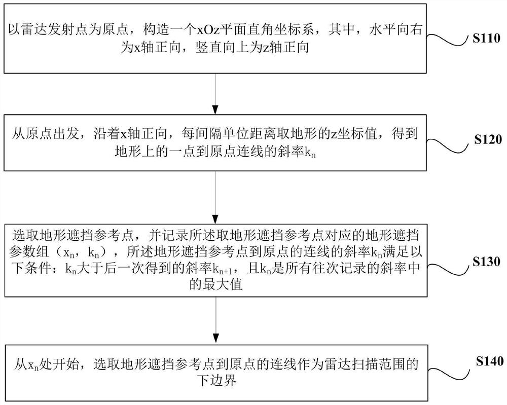
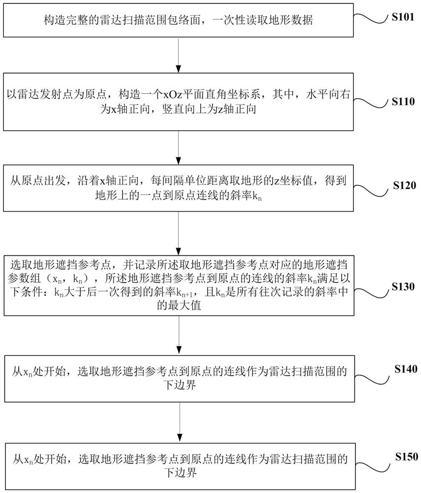
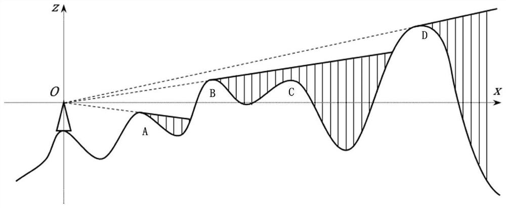
The invention relates to an algorithm for a terrain shielding radar scanning range envelope surface, and the algorithm comprises the steps: constructing an xOz plane rectangular coordinate system by employing a radar transmitting point as an original point, and enabling the horizontal right direction to be the x-axis forward direction and the vertical upward direction to be the z-axis forward direction; starting from the original point, taking z coordinate values of the terrain at intervals of unit distance along the forward direction of the x axis to obtain a slope kn of a connecting line from one point on the terrain to the original point; selecting a terrain occlusion reference point, recording a terrain occlusion parameter set (xn, kn) corresponding to the terrain occlusion reference point, and the slope kn of the connecting line from the terrain occlusion reference point to the original point satisfying the following conditions that kn is larger than the slope kn + 1 obtained later, and kn being the maximum value of all slopes recorded last time; and starting from xn, selecting a connecting line from the terrain occlusion reference point to an original point as a lower boundary of a radar scanning range. According to the method, complex terrain data is simplified, a small number of parameters of terrain occlusion information in a large range can be transmitted to a GPU through a UBO, and the drawing performance is greatly improved.

Description

technical field [0001] The invention relates to the field of three-dimensional geographic situation visualization, in particular to an algorithm for covering an envelope surface of a radar scanning range by terrain. Background technique [0002] The current terrain occlusion calculation method generally considers relatively simple terrain, or directly uses a large amount of original terrain elevation data for calculation when considering complex terrain, or cannot adapt to the dynamic change of radar scanning range, and cannot fully utilize the advantages of GPU hardware acceleration , the actual calculation efficiency is not high, and it is difficult to meet the requirements of real-time rendering. Contents of the invention [0003] In view of the above problems, the present invention is proposed to provide an algorithm for terrain occlusion of the envelope surface of a radar scanning range that overcomes the above problems or at least partially solves the above problems....

Claims


Application Information

Patent Timeline
Patent Type & Authority Applications(China)
IPC IPC(8): G01S13/89
CPCG01S13/89
Inventor 李欣刘难贵姚淑君周豫齐张锋叶张宇张翠红
Owner 北京庚图科技有限公司
Learn More