Satellite in-orbit application-oriented remote sensing image text intelligent description method

A remote sensing image and remote sensing image technology, applied in the field of remote sensing, can solve the problems of classification results and high-level scene semantics, semantic gap, interpretation level stay, no scene, etc.

Active Publication Date: 2020-10-27
PLA PEOPLES LIBERATION ARMY OF CHINA STRATEGIC SUPPORT FORCE AEROSPACE ENG UNIV
View PDF3 Cites 16 Cited by
  • Summary
  • Abstract
  • Description
  • Claims
  • Application Information

AI Technical Summary

Problems solved by technology

Previously, the processing methods in the field of high-resolution remote sensing image interpretation have basically completed the transformation from pixel-oriented classification to object-oriented classification methods, but the interpretation level still stays at the object category level, and there is no reasoning and understanding of the scene. Unable to resolve the "semantic gap" between classification results and high-level scene semantics

Method used


Image

  • Satellite in-orbit application-oriented remote sensing image text intelligent description method
  • Satellite in-orbit application-oriented remote sensing image text intelligent description method
  • Satellite in-orbit application-oriented remote sensing image text intelligent description method

Examples


Embodiment Construction

[0051] In order to enable those skilled in the art to better understand the technical solution of the present invention, the present invention will be described in further detail below in conjunction with the accompanying drawings and specific embodiments. And the features in the embodiments can be combined with each other.

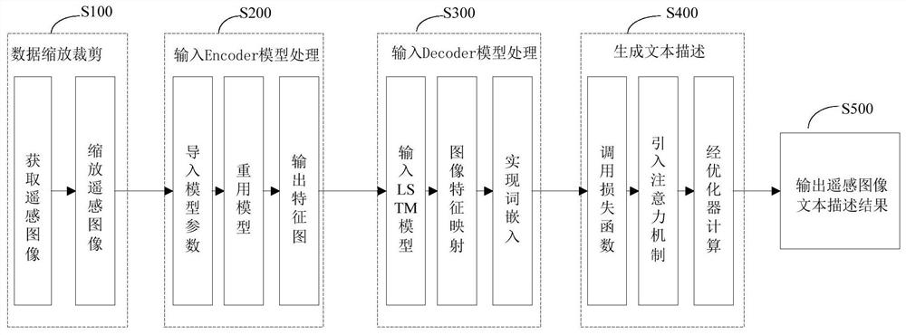
[0052] Such as figure 1 As shown, the embodiment of the present invention provides a remote sensing image text intelligent description method for satellite in-orbit applications, including the following steps:

[0053] S100. Data zooming and cropping: acquiring remote sensing images for testing, and zooming and cropping the remote sensing images;

[0054] S200, input Encoder (encoder) model processing: import trained model parameters, reuse the model to ensure its validity, output feature map after multi-layer convolutional neural network;

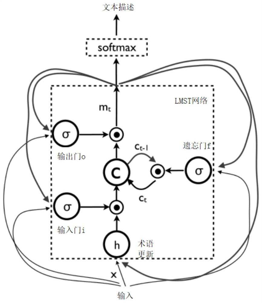
[0055] S300, input Decoder (decoder) model processing: in the Decoder model based on LSTM (Long Short-Term Memory...


PUM


Abstract

The invention discloses a satellite in-orbit application-oriented remote sensing image text intelligent description method, which comprises the following steps of S100, data scaling and clipping: obtaining a remote sensing image for testing, and scaling and clipping the remote sensing image; s200, inputting into Encoder model for processing: importing trained model parameters, reusing the model toensure the effectiveness of the model, and outputting a feature map after the model passes through a multi-layer convolutional neural network; s300, inputting into a Decoder model for processing: inthe Decoder model based on the LSTM model, realizing feature mapping and word embedding of the image through the LSTM model; s400, generating text description: generating a remote sensing image semantic text description result under the constraint of an attention mechanism and a self-critical sequence training method in reinforcement learning; and S500, outputting a remote sensing image text description result. According to the invention, a residual network structure, two layers of LSTM models, an attention mechanism combining bottom to top and top to bottom and a self-critical sequence training method in reinforcement learning are introduced, and text semantic description can be rapidly and accurately generated for remote sensing images.

Description

technical field [0001] The invention belongs to the technical field of remote sensing, and in particular relates to a remote sensing image text intelligent description method for satellite in-orbit application. Background technique [0002] The rapid development of remote sensing technology provides a large amount of data accumulation for the acquisition of earth surface information, and at the same time promotes the rapid development of related technologies such as remote sensing image analysis and processing, establishment of high-resolution data sets, spatial data analysis, and network sharing. progress. Previously, the processing methods in the field of high-resolution remote sensing image interpretation have basically completed the transformation from pixel-oriented classification to object-oriented classification methods, but the interpretation level still stays at the object category level, and there is no reasoning and understanding of the scene. The "semantic gap" ...

Claims


Application Information

Patent Timeline
Patent Type & Authority Applications(China)
IPC IPC(8): G06K9/00G06K9/62G06N3/04G06N3/08
CPCG06N3/049G06N3/08G06V20/13G06N3/047G06N3/048G06N3/045G06F18/241G06F18/2415
Inventor 夏鲁瑞董正宏林郁李森王俊锋薛武杨帆
Owner PLA PEOPLES LIBERATION ARMY OF CHINA STRATEGIC SUPPORT FORCE AEROSPACE ENG UNIV
Why Eureka
Try Eureka