Three-dimensional geographic data-oriented transmission and rendering method and system

A geographic data and three-dimensional technology, applied in the field of transmission and rendering methods and systems for three-dimensional geographic data, can solve the problems of web-side data transmission performance loss, rendering performance loss, not supporting the overall compression mechanism, etc., to achieve data transmission efficiency. and rendering efficiency, reducing performance loss, reducing the effect of loss

Active Publication Date: 2020-10-30
BEIJING EGOVA TECH
View PDF6 Cites 14 Cited by
  • Summary
  • Abstract
  • Description
  • Claims
  • Application Information

AI Technical Summary

Problems solved by technology

3D Tiles can provide the expression of multi-source 3D data, but as a general format, it lacks optimization for specific data types: such as texture merging, material merging, vertex merging, etc., resulting in loss of rendering performance; although glTF inside 3DTiles can provide compression mechanism, but does not support the overall compression mechanism, resulting in loss of data transmission performance on the Web side

Method used


Image

  • Three-dimensional geographic data-oriented transmission and rendering method and system
  • Three-dimensional geographic data-oriented transmission and rendering method and system
  • Three-dimensional geographic data-oriented transmission and rendering method and system

Examples


Embodiment 1

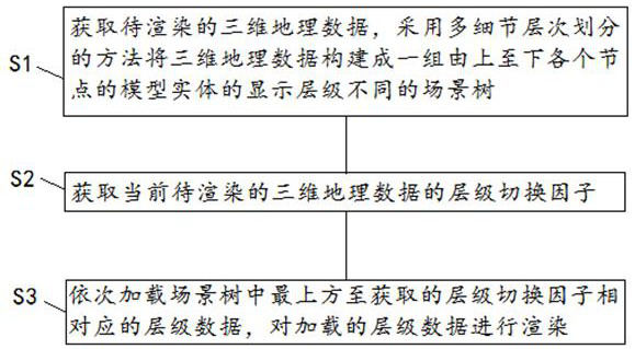
[0063] Such as figure 1 As shown, the present application provides a transmission and rendering method for three-dimensional geographic data, including the following steps:

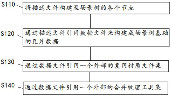
[0064] Step S1, acquiring the 3D geographic data to be rendered, and constructing the 3D geographic data into a set of scene trees with different display levels of the model entities of each node from top to bottom by adopting the multi-detail level division method. Wherein, each node in the scene tree includes a description file and a data file.

[0065] Among them, multiple display levels of the model entities in the scene are created in the scene tree at the same time, and the number of faces and the level of detail displayed by the model entities displayed at different display levels are different. The leaf nodes combined into the scene tree will choose to display sub-nodes according to the distance between the observation point and the node or according to the pixel size occupied by the current mode...

Embodiment 2

[0126] Such as Figure 5 As shown, the present application provides a transmission and rendering system 100 for three-dimensional geographic data, including:

[0127] The scene tree construction module 10 is used to divide the three-dimensional geographical data into a page detail level model, and construct a set of scene trees from top to bottom;

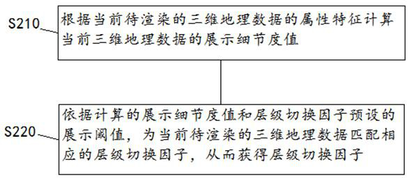
[0128] An acquisition module 20, configured to acquire a level switching factor of the three-dimensional geographic data currently to be rendered;

[0129] The rendering module 30 is configured to sequentially load the layer data corresponding to the obtained layer switching factor from the uppermost (ie, the parent) in the scene tree, and render the loaded layer data.

[0130] The beneficial effect that this application realizes is as follows:

[0131] (1) The flexible three-dimensional data organization form of this application. It satisfies the expression of multi-source 3D data types such as oblique photographic models, lase...


PUM


Abstract

The invention provides a three-dimensional geographic data-oriented transmission and rendering method and system, and the method comprises the following steps: obtaining to-be-rendered three-dimensional geographic data, and building the three-dimensional geographic data into a group of scene trees with different display hierarchies of model entities of all nodes from the top to the bottom througha multi-detail level division method, wherein each node in the scene tree comprises a description file and a data file; obtaining a hierarchy switching factor of the current three-dimensional geographic data to be rendered; sequentially loading the hierarchical data corresponding to the hierarchical switching factors from the uppermost side to the acquired side in the scene tree, and rendering theloaded hierarchical data. The three-dimensional data organization form provided by the invention meets the expression of multi-source three-dimensional data types, supports model objectification andmonomerization, and attaches attributes, so the file transmission efficiency is improved, and the data processing efficiency during rendering is improved.

Description

technical field [0001] The present application relates to the technical field of three-dimensional geographic data, in particular to a transmission and rendering method and system for three-dimensional geographic data. Background technique [0002] In recent years, with the development of various 3D data such as oblique photographic modeling, laser point cloud, CAD / BIM, higher requirements have been put forward for GIS 3D visualization technology, which is mainly reflected in: [0003] 1. The amount of 3D data used is large, which is likely to cause performance bottlenecks in data processing and rendering. [0004] 2. According to the actual usage scenario, different levels of data are displayed. The higher the level, the higher the accuracy of the displayed data. [0005] 3. It can be released efficiently, and can be applied to the web application scenarios of data sharing to meet the performance requirements of data transmission. [0006] 4. It can satisfy the expression...

Claims


Application Information

Patent Timeline
Patent Type & Authority Applications(China)
IPC IPC(8): G06F16/29G06T17/00G06T17/05
CPCG06T17/005G06T17/05G06F16/29
Inventor 朱兴亮程雷卢战胜李晓辉
Owner BEIJING EGOVA TECH
Why Eureka
Try Eureka