Distributed real-time deployment three-dimensional positioning method fusing ultra wide band and Beidou signal

A Beidou signal and three-dimensional positioning technology, which is applied in satellite radio beacon positioning systems, positioning, and measuring devices, can solve problems such as inconsistent coordinate systems, indiscriminate real-time deployment positioning, etc.

Active Publication Date: 2020-11-10
北京理工大学重庆创新中心
View PDF4 Cites 2 Cited by
  • Summary
  • Abstract
  • Description
  • Claims
  • Application Information

AI Technical Summary

Problems solved by technology

In summary, the two problems that need to be solved at present are: (1) real-time deployment and positioning without distinguishing between anchor points and tags in sensor networks; (2) distributed positioning to improve system invulnerability
[0016] In addition, in the process of indoor and outdoor integrated positioning, the coordinate systems used in the indoor and outdoor environments are not uniform

Method used


Image

  • Distributed real-time deployment three-dimensional positioning method fusing ultra wide band and Beidou signal
  • Distributed real-time deployment three-dimensional positioning method fusing ultra wide band and Beidou signal
  • Distributed real-time deployment three-dimensional positioning method fusing ultra wide band and Beidou signal

Examples


Embodiment 1

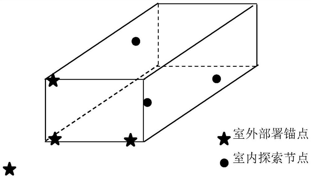
[0074] When quickly exploring unknown indoor scenes such as tunnels and caves, it is impossible to calibrate and deploy anchor points in advance. Therefore, real-time deployment without distinguishing node identities is of great significance to this scene. Its application scenarios are as follows: figure 1 shown.

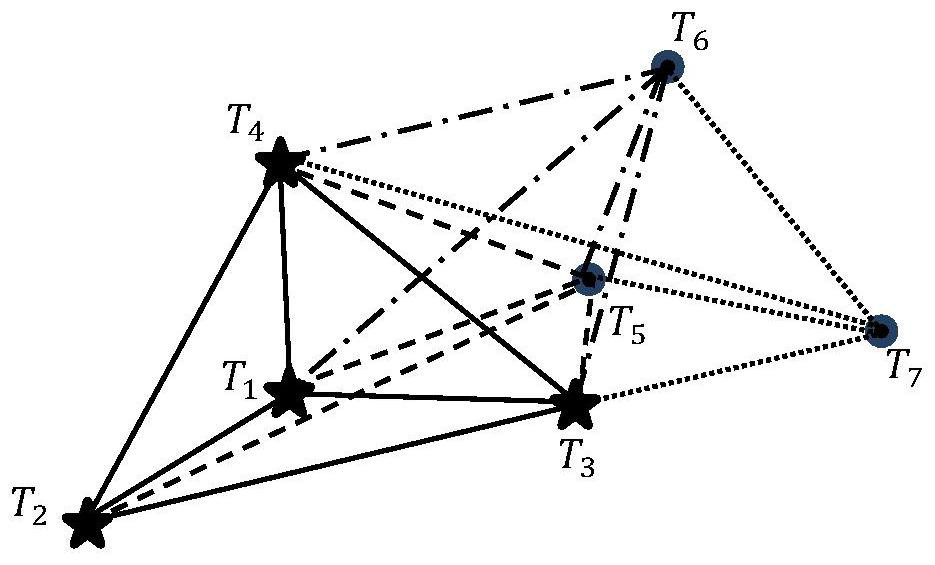
[0075] When preparing to quickly explore a cave, the anchor point can only be artificially marked at the entrance of the cave, such as figure 1 As shown by the asterisk in the center, the anchor point is composed of the Beidou module and the UWB node. The sensor nodes in the cave include only UWB nodes, and no longer distinguish their anchors and tags, so there is no need to manually calibrate the anchors. Before going deeper into the cave, the nodes are continuously arranged in the cave to build a UWB sensor network (such as figure 2 As shown), all nodes in the sensor network calculate their own positions through the distributed scheme of communicating with neig...


PUM


Abstract

The invention discloses a distributed real-time deployment three-dimensional positioning method fusing an ultra wide band and a Beidou signal, and belongs to the technical field of indoor positioning,the positioning method comprises the following steps: S1, constructing a sensor network based on a Beidou module and an ultra wide band module, and calculating the barycentric coordinate of any nodeTh to be positioned in the sensor network; s2, solving a positioning result of any to-be-positioned node Th through parallel distributed calculation, and performing iterative convergence on the positioning result; s3, taking the positioning result as an initial value of Taylor expansion, and solving a final positioning result; and S4, converting the final positioning result under the relative coordinate system into an absolute coordinate system so as to achieve distributed positioning under the relative coordinate system by utilizing the ultra-wideband sensor network, and then converting the relative coordinate into an absolute coordinate through a Beidou module on the anchor point so as to achieve positioning of the sensor network under a geodetic coordinate system, thereby achieving positioning of the sensor network under the geodetic coordinate system. Therefore, the purpose of indoor and outdoor integrated positioning is achieved.

Description

technical field [0001] The invention belongs to the technical field of indoor positioning, and in particular relates to a distributed real-time deployment three-dimensional positioning method that integrates ultra-wideband and Beidou signals. Background technique [0002] China's Beidou Navigation Satellite System (BDS) is a global satellite navigation system independently developed by China. It is the third mature satellite in the world after the US Global Positioning System GPS and the Russian GLONASS satellite navigation system. Navigation System. The Beidou satellite navigation system consists of three parts: the air segment, the ground segment, and the user segment. It can provide high-precision, high-reliability positioning, navigation, and timing services for all types of users around the world, all-weather, and has short message The communication capability has preliminarily possessed regional navigation, positioning and timing capabilities. The Beidou satellite na...

Claims


Application Information

Patent Timeline
Patent Type & Authority Applications(China)
IPC IPC(8): G01S19/46G01S5/02
CPCG01S19/46G01S5/0257Y02D30/70
Inventor 俞成浦何澄洋
Owner 北京理工大学重庆创新中心
Why Eureka
Try Eureka