Method for processing vector and raster slice data in power GIS

A technology of vector data and raster data, which is applied in the field of processing vector and raster slice data in electric power GIS. It can solve problems such as increasing system load, users cannot quickly view map content, and reducing loading speed, so as to reduce transmission pressure, Improve loading and display efficiency and reduce burden

Pending Publication Date: 2020-11-10
CHINA ELECTRIC POWER RES INST +2
View PDF0 Cites 4 Cited by
  • Summary
  • Abstract
  • Description
  • Claims
  • Application Information

AI Technical Summary

Problems solved by technology

And for most map display engines, no matter what resolution the user needs to view the map, it is to directly load a large amount of basic pixel data of the image for display. For

Method used


Image

  • Method for processing vector and raster slice data in power GIS

Examples


Embodiment Construction

[0025] In order to better understand the present invention, the method and system of the present invention will be further described below with reference to the description of the embodiments in conjunction with the accompanying drawings.

[0026] In the following detailed description, numerous specific details are set forth in order to provide a thorough understanding of the present invention. However, it will be understood by those skilled in the art that the present invention may be practiced without these specific details. In the embodiments, well-known methods, procedures, components have not been described in detail so as not to unnecessarily obscure the embodiments.

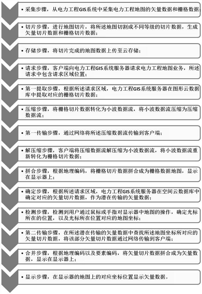
[0027] see figure 1 As shown, the present invention provides a kind of method for processing vector and raster slice data in electric power GIS, comprises the following steps:

[0028] The collection step is to collect vector data and raster data of the electric power engineering map from the electric po...


PUM


Abstract

The invention discloses a method for processing vector and raster slice data in an electric power GIS. The method comprises a collection step, a slicing step, a storage step, a request step, a first extraction step, a compression step, a first transmission step, a decompression step, a splicing step, a determination step, a detection step, a second transmission step, a merging step and a display step. By cloud storage, high system redundancy and security are provided and convenient storage is achieved. Due to the application of raster slice data and vector slice data, the access frequency of cloud storage is reduced, the server pressure can be effectively reduced, and the network load and the network delay are reduced.

Description

technical field [0001] The invention belongs to the technical field of electric power geographic information, and in particular relates to a method for processing vector and grid slice data in electric power GIS. Background technique [0002] With the continuous development of high-precision detection technology, more and more massive image data are gradually produced in various application fields, such as high-resolution satellite remote sensing image data in the field of remote sensing, high-definition medical images in the field of medicine, and laser points in the field of 3D scanning. Cloud data, etc., due to the characteristics of large data volume and rich information, the emergence of massive image data poses higher challenges for corresponding storage, management and display technologies. [0003] With the development of Internet technology, one of the main development directions of geographic information system is multivariate data access, which requires that in di...

Claims


Application Information

Patent Timeline
IPC IPC(8): G06F16/29G06F16/56
CPCG06F16/29G06F16/56
Inventor 王宪金欢王轶马潇王寒
Owner CHINA ELECTRIC POWER RES INST
Why Eureka
Try Eureka