Multispectral aerial surveying and mapping module

A multi-spectral, aeronautical technology, applied in the field of aerial surveying and mapping, can solve the problems of measuring the pollution of aircraft measuring filters, and achieve the effect of avoiding equipment crashes, avoiding inaccurate surveying and mapping, and intelligent safety prompts.

Pending Publication Date: 2020-11-20
MOONLIGHT (NANJING) INSTR CO LTD
5 Cites 2 Cited by

AI-Extracted Technical Summary

Problems solved by technology

[0005] Aiming at the deficiencies of the prior art, the present invention provides a multi-spectral aerial surveying and...

Method used

As shown in Figure 1-2, the embodiment of the present invention provides a kind of multi-spectral aerial surveying and mapping module, comprises unmanned aerial vehicle, unmanned aerial vehicle and anti-collision early warning module information interaction, make prediction in time by anti-collision early warning module , to avoid accidental mid-air collisions when the UAV is controlled, the UAV is connected to a multi-spectral mapping module, and aerial mapping is realized through the multi-spectral mapping module. The optical filter of the surveying and mapping module and the power system of the drone provide electric energy for the collision avoidance warning module and the multispectral surveying and mapping module, so that the collision avo...

Abstract

The invention provides a multispectral aerial surveying and mapping module, and relates to the technical field of aerial surveying and mapping. The multispectral aerial surveying and mapping module comprises a unmanned aerial vehicle. The unmanned aerial vehicle performs information interaction with the anti-collision early warning module. The unmanned aerial vehicle is connected with a multispectral surveying and mapping module. The multispectral surveying and mapping module is connected with an optical lens cleaning module. An electric power system of the unmanned aerial vehicle provides electric energy for the anti-collision early warning module and the multispectral surveying and mapping module. The anti-collision early warning module recognizes the situation of 200 M around the unmanned aerial vehicle, obstacles are effectively avoided in advance, air collision is avoided, and the optical lens cleaning module is a cleaning device based on scraping and brushing and is used for cleaning a filter at the position of the multispectral surveying and mapping module. Fixed obstacles and movable obstacles can be effectively avoided, surveying and mapping are safer, losses caused by crash of the unmanned aerial vehicle and the multispectral measuring instrument are avoided, meanwhile, a filter of the multispectral measuring instrument is cleaned through the optical lens cleaning module, and the surveying and mapping precision is higher.

Application Domain

Method using image detector and image signal processingPhotogrammetry/videogrammetry +4

Technology Topic

Real-time computingMulti spectral +2

Image

  • Multispectral aerial surveying and mapping module
  • Multispectral aerial surveying and mapping module

Examples

  • Experimental program(1)

Example Embodiment

[0024] Example one:
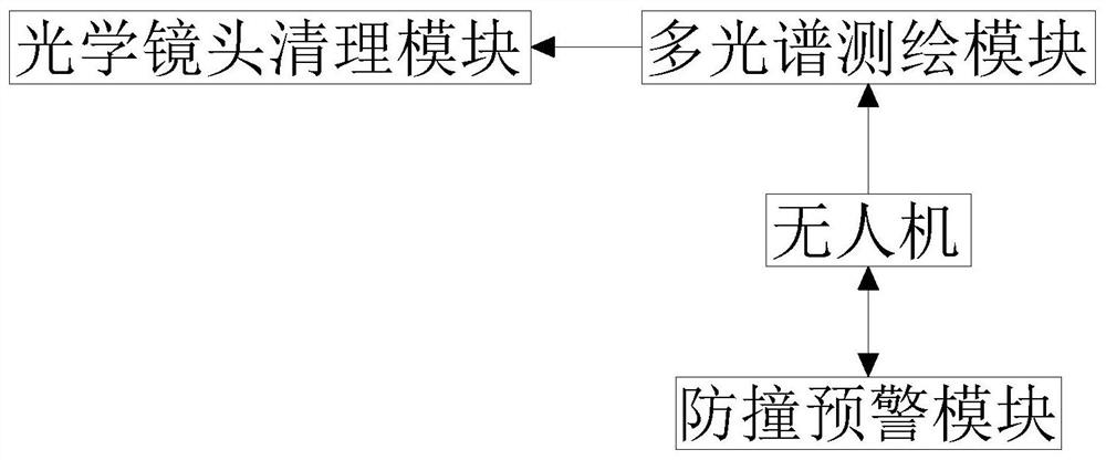
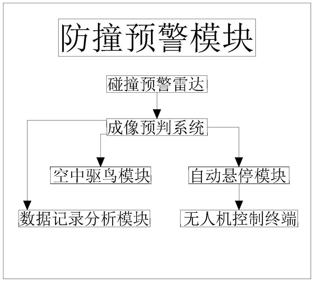
[0025] Such as Figure 1-2 As shown, the embodiment of the present invention provides a multi-spectral aerial surveying and mapping module, including a drone. The drone interacts with the collision avoidance warning module. The collision avoidance warning module makes timely predictions to avoid accidental control of the drone. When an air collision occurs, the drone is connected to the multi-spectral surveying and mapping module, and the multi-spectral surveying and mapping module is used to realize the aerial surveying and mapping. The multi-spectral surveying and mapping module is connected to the optical lens cleaning module. The optical lens cleaning module is used to clean the optical filter of the multi-spectral mapping module. The power system of the man-machine provides power for the collision avoidance warning module and the multispectral surveying and mapping module, so that the collision avoidance warning module and the multispectral surveying and mapping module have energy to operate normally. The collision avoidance warning module recognizes the situation around 200M of the drone, and the 200M recognition range makes The drone can avoid fixed obstacles or expel moving obstacles in time, effectively avoid obstacles in advance, and avoid aerial collisions. The optical lens cleaning module is a scraper-based cleaning device that cleans the position filters of the multispectral mapping module.
[0026] The collision avoidance warning module includes a collision warning radar. The collision warning radar is connected with an imaging prediction system. The imaging prediction system is connected with an aerial bird repellent module, an automatic hovering module and a data recording and analysis module, an automatic hovering module and a drone control terminal Connected, when the automatic hovering module is activated, the drone maintains a vertical height and does not move horizontally, so that it can move after removing the obstacles.
[0027] The specific operation method of the anti-collision warning module is as follows:
[0028] S1. The collision warning radar can be started when the UAV is running, and the signal will be transmitted to the imaging prediction system when the collision warning radar detects an obstacle;
[0029] S2. The imaging pre-judgment system recognizes the signal of the sensed object. If the sensed object is a moving object, it can be judged as a bird, and the signal can be transmitted to the aerial bird repelling module, and the aerial bird repelling module can be activated to remove flying birds. Drive away, if the sensing object is a non-moving object, it can be judged as a fixed obstacle, and the signal can be transmitted to the automatic hovering module. Whether it is a moving object or a non-moving object, the signal is transmitted to the data recording analysis module for storage ;
[0030] S3. When the automatic hovering module receives the signal, it will transmit the signal to the drone control terminal, and control the drone to hover through the drone control terminal;
[0031] S4. When the data recording analysis module receives the data, it counts and classifies the moving obstacles and non-moving obstacles in the fixed area.
[0032] The aerial bird repellent module is a device based on a strobe light and ultrasonic generator. When the aerial bird repellent module is activated, the strobe light and ultrasonic generator are activated to scare away the birds. The birds are more sensitive to ultrasonic waves and feel abnormal Birds will stay away during sound waves to avoid collisions.
[0033] The data recording and analysis module is an integrated device based on a microprocessor, GPS and storage device. The measurement area is modeled by GPS, and the traffic is restricted. The measurement area is set in the microprocessor for moving obstacles and fixed obstacles. The upper limit of the value. When the detected value exceeds the upper limit of the setting, the drone will issue an early warning of frequent accidents when measuring the same area next time, reminding you to handle it carefully. The UAV is a high-power diesel UAV. When the UAV is running, the power supply system is charged by diesel, so that as long as the UAV runs the collision avoidance warning module and the multispectral surveying and mapping module, there is energy to support the operation.

PUM

no PUM

Description & Claims & Application Information

We can also present the details of the Description, Claims and Application information to help users get a comprehensive understanding of the technical details of the patent, such as background art, summary of invention, brief description of drawings, description of embodiments, and other original content. On the other hand, users can also determine the specific scope of protection of the technology through the list of claims; as well as understand the changes in the life cycle of the technology with the presentation of the patent timeline. Login to view more.

Similar technology patents

System and method for continuously monitoring emission of smoke particles

InactiveCN110793816Aavoid interferenceMeasure security
Owner:江阴市中源环境仪器有限公司

Classification and recommendation of technical efficacy words

  • Measure security

System and method for continuously monitoring emission of smoke particles

InactiveCN110793816Aavoid interferenceMeasure security
Owner:江阴市中源环境仪器有限公司
Why Eureka
Try Eureka