Unmanned aerial vehicle image rapid three-dimensional reconstruction method for field unknown environment

An unknown environment and 3D reconstruction technology, applied in the field of rapid 3D reconstruction of UAV images, can solve the problems of high image resolution, inability to achieve fast reconstruction or even real-time reconstruction, and inability to meet fast reconstruction, so as to improve grid quality and enhance The effect of 3D reconstruction details

Active Publication Date: 2020-12-15
NAT INNOVATION INST OF DEFENSE TECH PLA ACAD OF MILITARY SCI
View PDF6 Cites 12 Cited by
  • Summary
  • Abstract
  • Description
  • Claims
  • Application Information

AI Technical Summary

Problems solved by technology

[0003] For the 3D reconstruction requirements of wild scenes, if it is realized based on the satellite platform, there is a problem of insufficient resolution, and it is impossible to clearly construct a 3D scene in the wild
For more accurate radar laser scanning reconstruction, it has the disadvantage of being expensive and heavy, and it is very inconvenient to perform 3D reconstruction in the field environment
Most of the traditional image-based 3D reconstruction methods have shortcomings such as long running time, poor timeliness, and high requirements for equipment, which cannot meet the needs of rapid reconstruction such as emergency rescue and disaster relief, military reconnaissance, and border security.
For fast and even real-time 3D reconstruction under this requirement, traditional metho...

Method used


Image

  • Unmanned aerial vehicle image rapid three-dimensional reconstruction method for field unknown environment
  • Unmanned aerial vehicle image rapid three-dimensional reconstruction method for field unknown environment
  • Unmanned aerial vehicle image rapid three-dimensional reconstruction method for field unknown environment

Examples


Embodiment

[0084] Embodiment: A method for fast 3D reconstruction of UAV images in an unknown environment in the field

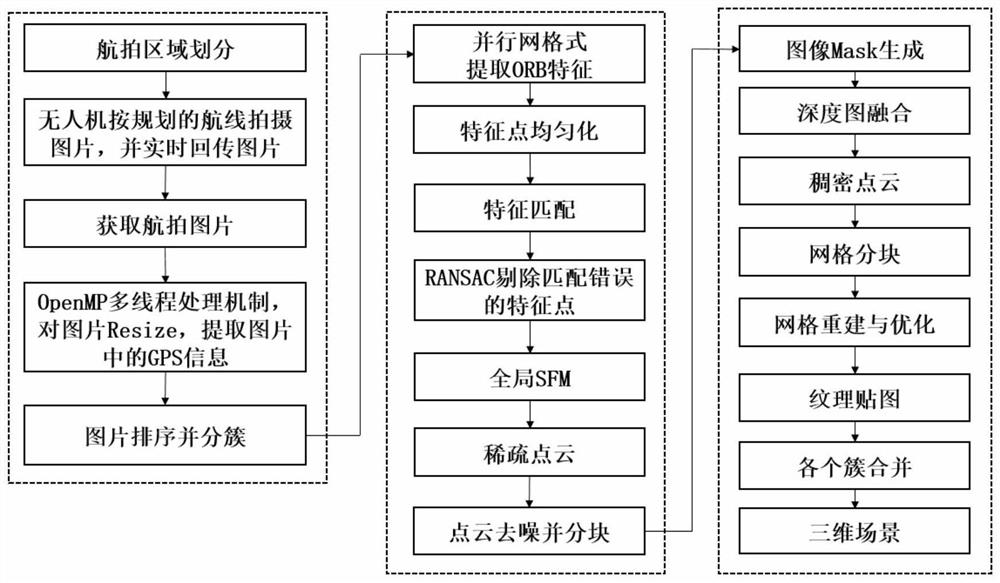
[0085] figure 1 A flow chart of a method for rapid 3D reconstruction of UAV images for unknown field environments is given. This embodiment discloses a method for rapid three-dimensional reconstruction of UAV images facing unknown environments in the field, including the following steps:

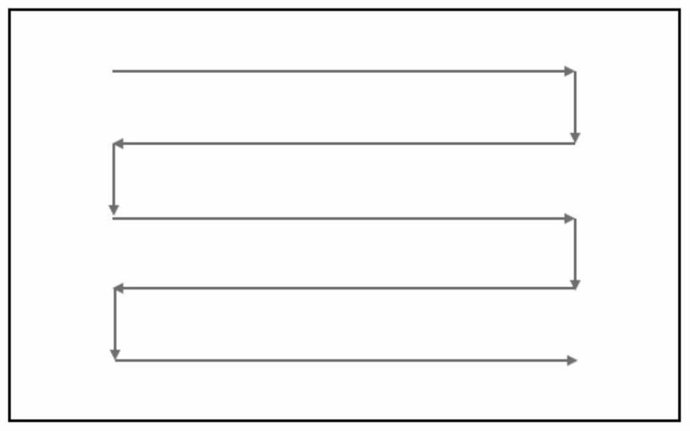
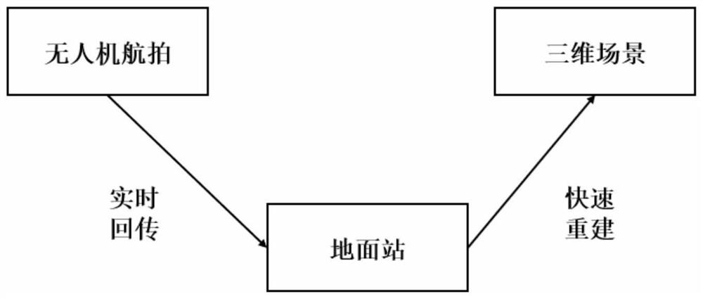
[0086] S1, first divide the aerial photography area through the ground station of the UAV, and plan the flight path of the UAV in a zigzag shape. The single camera carried by the drone shoots the monocular vision image sequence of the scene to be reconstructed, and the UAV sends back the captured pictures and RTK information to the UAV ground station in real time during the process of taking images;

[0087] S2. After receiving the picture taken by the drone, the UAV ground station adopts the OpenMP multi-thread processing mechanism to scale the picture and extract the GPS informat...


PUM


Abstract

The invention discloses an unmanned aerial vehicle image rapid three-dimensional reconstruction method for a field unknown environment. According to the invention, the method includes using an OpenMPmulti-thread processing mechanism to resize image returned by an unmanned aerial vehicle, sorting the images, extracting feature points in a parallel grid format, obtaining sparse point clouds of allimage clusters through a global motion recovery structure, calculating depth images of the images, and constraining regions of interest through image Mask; and based on a depth map fusion method, obtaining the dense point cloud of each image cluster, and combining the reconstruction results of each cluster to obtain the three-dimensional structure of the whole scene. The method can be realized without depending on complex image acquisition equipment and computer equipment, and the reconstruction speed is greatly improved by using parallel grid type feature extraction; through point cloud partitioning and grid partitioning, the memory pressure is reduced, and the reconstruction speed is increased.

Description

technical field [0001] The invention relates to the field of unmanned aerial vehicle technology and the field of three-dimensional reconstruction, in particular to a method for rapid three-dimensional reconstruction of unmanned aerial vehicle images facing unknown environments in the field. Background technique [0002] At present, in outdoor or field applications, UAVs can realize rapid and comprehensive three-dimensional reconstruction of a scene, such as forestry resource protection in the wild, post-disaster rescue of fires and earthquakes, border security, oil fields or offshore platform oil and gas facilities, and power facilities. Monitoring and other fields have very important application value. [0003] For the 3D reconstruction requirements of wild scenes, if it is realized based on the satellite platform, there is a problem of insufficient resolution, and it is impossible to clearly construct a 3D scene in the wild. For more accurate radar laser scanning reconstr...

Claims


Application Information

Patent Timeline
IPC IPC(8): G06T17/05G06T17/20G06T15/04G06T19/20
CPCG06T15/04G06T17/05G06T17/205G06T19/20
Inventor 邓宝松庞巧遇唐荣富桂健钧李靖杨楚乐尚天赐
Owner NAT INNOVATION INST OF DEFENSE TECH PLA ACAD OF MILITARY SCI
Why Eureka
Try Eureka