Underwater topographic data identification and service method and system based on deep learning

A technology for underwater terrain and data identification, applied in geographic information databases, database indexes, structured data retrieval, etc., can solve problems such as lack of systematic collation and lack of underwater terrain data, and meet needs and broad market foreground effect

Active Publication Date: 2020-12-29
CHINA UNIV OF GEOSCIENCES (WUHAN)
View PDF4 Cites 4 Cited by
  • Summary
  • Abstract
  • Description
  • Claims
  • Application Information

AI Technical Summary

Problems solved by technology

At present, there is no technology and service system for underwater terrain recognition based on deep learning, but a large area of ​​underwater terrain data is missing and has not been systematically sorted out

Method used


Image

  • Underwater topographic data identification and service method and system based on deep learning
  • Underwater topographic data identification and service method and system based on deep learning

Examples


Embodiment Construction

[0044] In order to make the purpose, technical solution and advantages of the present invention clearer, the embodiments of the present invention will be further described below in conjunction with the accompanying drawings.

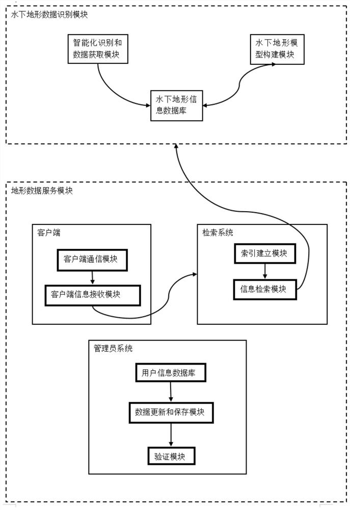
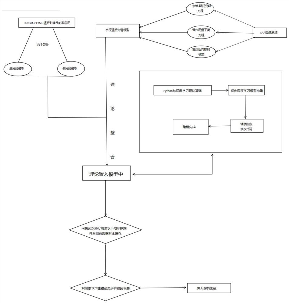
[0045] Using the underwater terrain data and remote sensing data of East Lake in Wuhan, a model training set was constructed to carry out the verification and optimization of the underwater terrain artificial intelligence recognition model. Apply the model to other lakes in my country to realize intelligent extraction of water depth and underwater topography of other lakes in Wuhan. Based on the extracted data, the underwater terrain service system of lakes in my country is constructed to provide underwater terrain services for scientific research, planning and management.

[0046] Please refer to figure 1 , the present invention discloses an underwater terrain data identification and service method and system based on deep learning, an underwater terra...


PUM


Abstract

The invention relates to an underwater topographic data identification and service method and system based on deep learning, and the method intelligently extracts lake underwater topographic data by abuilt-in deep learning model to form an underwater topographic database, and provides data service for the outside; the constructed system can accurately retrieve the underwater topographic data of the corresponding area according to the lake name or coordinate place input by the user, and the user can download the detailed geographic data of the lake and the surrounding from the system. Meanwhile, the system supports a user to upload lake underwater topographic data which is not covered by the system on line, background personnel upload the lake underwater topographic data and indicate datacontributors after carrying out related auditing, the lake underwater topographic data are used by people, and a certain amount of rewards are given to data providers. According to the invention, theproblem that the current underwater topographic data is difficult to obtain is solved, the requirements of related scientific research institutions and individuals on the underwater topographic data can be greatly met, and the market prospect is wide.

Description

technical field [0001] The invention relates to an underwater terrain data service system, in particular to a method and system for identifying and serving underwater terrain data based on deep learning. Background technique [0002] The development of water environment work based on artificial intelligence + water remote sensing is currently a research hotspot in geographic science and an important direction for the development of the discipline. At this stage, the lack of underwater terrain data is serious. The underwater terrain data obtained through remote sensing image acquisition or manual detection is usually carried out in a single manner, which cannot be obtained in large quantities. There are certain difficulties in horizontal and vertical comparison and statistical analysis. The accuracy of manual measurement of underwater terrain is not enough, and it is time-consuming and labor-intensive. It is impossible to conduct a comprehensive exploration of more dangerous ...

Claims


Application Information

Patent Timeline
IPC IPC(8): G06F16/29G06F16/22G06F16/242
CPCG06F16/29G06F16/2228G06F16/243
Inventor 王禹熹王永桂罗梦梦姚如意
Owner CHINA UNIV OF GEOSCIENCES (WUHAN)
Why Eureka
Try Eureka