Satellite-borne SAR real-time imaging device

A real-time imaging, spaceborne technology, applied in measurement devices, radio wave reflection/re-radiation, utilization of re-radiation, etc., can solve the problem that the processing efficiency and real-time performance cannot meet the needs of remote sensing satellites, reduce the communication efficiency of satellite-ground networks, Affect the performance of remote sensing satellites and other issues to achieve the effect of improving flexibility and timeliness, improving combat effectiveness, and improving classification accuracy

Active Publication Date: 2021-02-19
BEIJING INST OF SPACECRAFT SYST ENG
View PDF3 Cites 2 Cited by
  • Summary
  • Abstract
  • Description
  • Claims
  • Application Information

AI Technical Summary

Problems solved by technology

[0009] (3) The existing method mainly considers the application on the ground or the participation of ground equipment to complete the functional closed loop. It must rely on the space-ground data transmission system and occupy a large amount of satellite-ground communication bandwidth, which will inevitably consume a lot of processing time and reduce the communication efficiency of the satellite-ground network. Further affect the effectiveness of remote sensing satellites, processing efficiency and real-time will not be able to meet the needs of modern remote sensing satellites

Method used


Image

  • Satellite-borne SAR real-time imaging device
  • Satellite-borne SAR real-time imaging device
  • Satellite-borne SAR real-time imaging device

Examples


Embodiment Construction

[0038] The present invention will be described in detail below with reference to the accompanying drawings and examples.

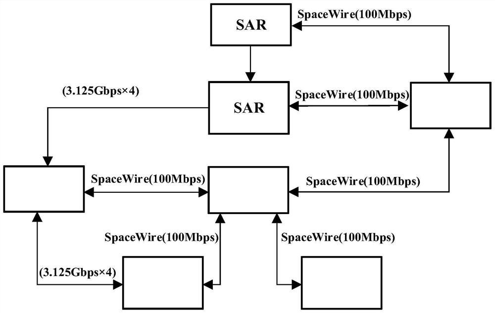
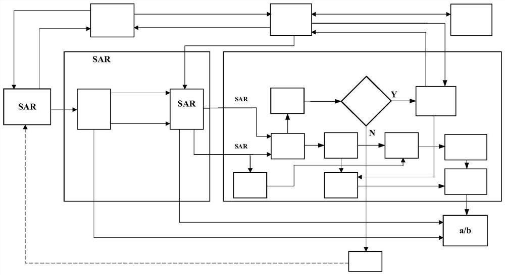
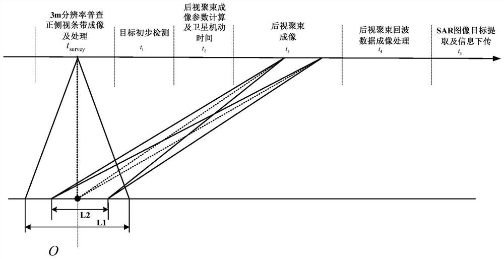
[0039] A spaceborne SAR real-time imaging device, such as figure 1 As shown, it includes a satellite attitude orbit control unit, a central processing unit, a SAR payload, a SAR imaging processing unit, an intelligent information processing unit, a data processing unit, and a payload control unit. The above modules cooperate to complete the satellite SAR imaging task. like figure 2 As shown, the task flow is set to firstly carry out low-resolution wide-area census SAR imaging of frontal and side-looking strips, and conduct preliminary detection of the target of interest on the obtained SAR images, and organize the rear squint spotlight height according to the detection results and satellite-related information. Check the resolution of SAR imaging in detail, and perform interest target detection, slice extraction, and target identification based on deep l...


PUM


Abstract

The invention discloses a satellite-borne SAR real-time imaging device, and the device adopts two imaging modes of wide-area wide-width low-resolution general survey and high-resolution detailed survey to construct SAR imaging, combines satellite-borne SAR real-time imaging processing, target detection and a target classification and recognition technology based on deep learning to realize rapid and effective reconnaissance of a sensitive area, and obtains the number, positions, types, confidence coefficients, slices and other intelligence information of interested targets; the problems of large ground processing time delay, low timeliness and the like caused by direct downloading of massive high-resolution SAR data are effectively solved, the data transmission bottleneck is effectively broken through, the solid storage and load utilization rate is improved, and the combat effectiveness of a satellite is remarkably improved; the input data of the deep learning forward reasoning model is the floating point complex data, and the floating point complex data not only contains the target feature information, but also contains the phase information of the target, so that the informationdimension is increased, the information precision is high, and the classification accuracy is improved.

Description

technical field [0001] The invention belongs to the technical field of satellite payload data processing and platform control, and in particular relates to a spaceborne SAR real-time imaging device. Background technique [0002] Spaceborne SAR has the characteristics of high spatial resolution and large coverage area, which can realize the precise positioning of ship targets, and high-resolution SAR images provide the possibility for ship type identification, but it is difficult to effectively verify the ship extraction results, making the target The performance of extraction and type identification cannot be effectively improved. The deep learning technology emerging in recent years has been widely used in object classification, recognition, video analysis and natural language processing. With the help of deep learning technology, on-orbit target detection and identification based on remote sensing images can effectively improve the use efficiency of satellites, and timely...

Claims


Application Information

Patent Timeline
Patent Type & Authority Applications(China)
IPC IPC(8): G01S13/90
CPCG01S13/9005
Inventor 李宗凌陈继巍汪路元禹霁阳程博文蒋帅吴雨航栾申申庞亚龙郝梁
Owner BEIJING INST OF SPACECRAFT SYST ENG
Why Eureka
Try Eureka