Method and system for air-ground combined rapid investigation of traffic accidents
A traffic accident and fast technology, applied in traffic control system, road vehicle traffic control system, traffic flow detection, etc., can solve problems affecting accident rescue and other problems, achieve intuitive and accurate display effect, short planned route, and good rescue effect Effect
- Summary
- Abstract
- Description
- Claims
- Application Information
AI Technical Summary
Problems solved by technology
Method used
Image

Examples
Embodiment 1
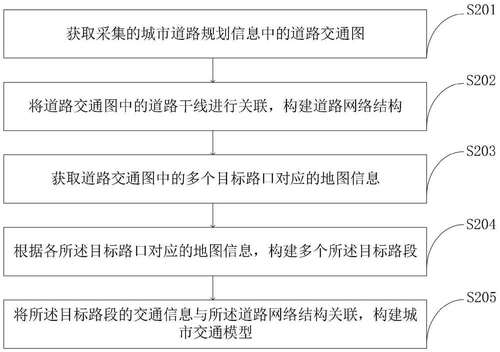
[0100] The method of the open-ground joint rapid investigation of traffic accidents provided by the embodiment of the present invention is as follows: figure 1 As shown, as a preferred embodiment, such as image 3 As shown, the traffic model construction module provided by the embodiment of the present invention uses the traffic model construction program to construct the urban traffic model according to the planning information analysis results, including:
[0101] S201, obtaining the road traffic map in the collected urban road planning information;
[0102] S202, associating the road arteries in the road traffic map to construct a road network structure;
[0103] S203, acquiring map information corresponding to multiple target intersections in the road traffic map;
[0104] S204. Construct a plurality of target road sections according to the map information corresponding to each of the target intersections;
[0105] S205, associating the traffic information of the target...
Embodiment 2
[0108] The method of the open-ground joint rapid investigation of traffic accidents provided by the embodiment of the present invention is as follows: figure 1 As shown, as a preferred embodiment, the preprocessing of the collected urban road images by the image analysis and processing module with the image processing program provided by the embodiment of the present invention includes:
[0109] Utilize the image processing program to obtain the normalized difference water index NDWI and the soil brightness index SBI of the urban road image collected by using the preset enhancement algorithm; according to the difference between the NDWI and SBI, the road area in the urban road image is enhanced. , to obtain the enhanced image; filter the enhanced image to obtain the filtered image, and use a similarity algorithm to calculate the similarity between the filtered road area and other non-road areas; according to the similarity , separating the road area and the non-road area in th...
Embodiment 3
[0113] The method of the open-ground joint rapid investigation of traffic accidents provided by the embodiment of the present invention is as follows: figure 1 As shown, as a preferred embodiment, the congested road determination module provided by the embodiment of the present invention uses the congested road determination program to determine the congested road interval according to the image analysis results, including: obtaining the image analysis results, according to the special points on the obtained image Calculate the graph and graph parameters formed by the special points, and output the graph and graph parameters. The graph area is the congested road section.
PUM
 Abstract
Description
Claims
Application Information
 - R&D
- Intellectual Property
- Life Sciences
- Materials
- Tech Scout
- Unparalleled Data Quality
- Higher Quality Content
- 60% Fewer Hallucinations
Browse by: Latest US Patents, China's latest patents, Technical Efficacy Thesaurus, Application Domain, Technology Topic, Popular Technical Reports.
© 2025 PatSnap. All rights reserved.Legal|Privacy policy|Modern Slavery Act Transparency Statement|Sitemap|About US| Contact US: help@patsnap.com