Method and system for fusing multi-source heterogeneous positioning path data

A multi-source heterogeneous and multi-source data technology, applied in the field of data processing, can solve the problems of fusion technology being opaque to users, high requirements for positioning equipment, and geomagnetic disturbance, so as to achieve high-quality positioning path fusion results, improve credibility, and avoid Effect of Insufficient Confidence

Active Publication Date: 2021-03-09
SHANGHAI JIAO TONG UNIV
View PDF10 Cites 6 Cited by
  • Summary
  • Abstract
  • Description
  • Claims
  • Application Information

AI Technical Summary

Problems solved by technology

The other is to record the signal strength of a huge amount of certain location points in advance, and determine the location by comparing the signal strength of the newly added device with the database with huge data; the geomagnetic positioning technology utilizes the basic magnetic field of the earth, and the modern building The reinforced concrete structure will disturb the geomagnetism in a local area. In principle, the non-uniform magnetic field environment will produce different magnetic field observation results due to different paths. Geomagnetic positioning uses the above positioning principle; base station positioning technology, mobile phone base station positioning The service is also called mobile location service (LBS——Location Based Service), which obtains the location information of mobile terminal users through the operator's network (such as GSM network); Google's fusion positioning technology (FLP, Fusion Location Positioning) through A variety of technologies have improved positioning accuracy, but they have high requirements for positioning equipment, and fusion technology is opaque to users
[0004] The above-mentioned various positioning technologies have positioning accuracy, equipment requirements, scope of application, interference factors, failure probability, etc. The data source using a single positioning technology cannot meet the needs of complex scenarios, and it is difficult to provide stable and reliable path data in complex environments
At present, there is a lack of a method and system that can dynamically fuse path data from multiple positioning data sources. The path data of each single positioning data source can be integrated through a fusion algorithm to achieve low-cost and reliable path positioning in complex scenarios.

Method used


Image

  • Method and system for fusing multi-source heterogeneous positioning path data
  • Method and system for fusing multi-source heterogeneous positioning path data
  • Method and system for fusing multi-source heterogeneous positioning path data

Examples


Embodiment Construction

[0057] The present invention will be described in detail below in conjunction with specific embodiments. The following examples will help those skilled in the art to further understand the present invention, but do not limit the present invention in any form. It should be noted that those skilled in the art can make several changes and improvements without departing from the concept of the present invention. These all belong to the protection scope of the present invention.

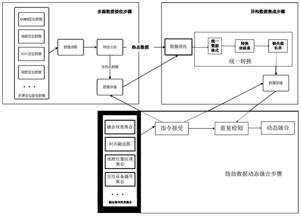
[0058] Such as figure 1 As shown, a method and system for fusing multi-source heterogeneous positioning route data provided by the present invention includes:

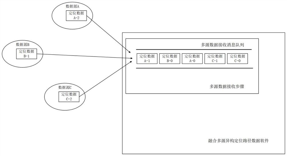
[0059] Multi-source data receiving step: receiving positioning path data from multiple data sources and in multiple formats.

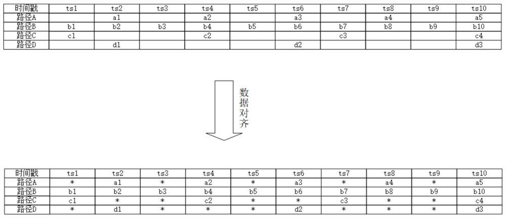
[0060] Heterogeneous data integration steps: clean and uniformly transform data from multiple data sources.

[0061] Path data dynamic fusion step: According to the individual needs of users, dynamically fuse the specifi...


PUM


Abstract

The invention provides a method and a system for fusing multi-source heterogeneous positioning path data. The method comprises the following steps: a multi-source data receiving step: receiving positioning path data from a plurality of data sources and in various formats; a heterogeneous data integration step: cleaning and uniformly converting the data from the plurality of data sources; and a path data dynamic fusion step: dynamically fusing the specified path data and outputting a fusion result according to the personalized demand of the user. By fusing the positioning path data from variousdata sources, the credibility of the data is improved, and low-cost reliable path positioning in a complex scene is realized.

Description

technical field [0001] The present invention relates to the technical field of data processing, in particular to a method and system for fusing multi-source heterogeneous positioning path data. Background technique [0002] With the advancement of technology, especially the popularization of mobile terminals, more and more positioning technologies are applied to indoor and outdoor positioning scenarios to meet the growing demand for location services. [0003] There are dozens or hundreds of technologies used for indoor and outdoor positioning. The common ones are: GNSS (Global Navigation Satellite System) positioning system, which is a space-based radio system that provides users with three-dimensional coordinates, speed and time information. Navigation and positioning system. GNSS currently covers four global systems, including GPS in the United States, GLONASS in Russia, Galileo in Europe and BDS (BeiDou Satellite Navigation System) in China; there are two main types of ...

Claims


Application Information

Patent Timeline
Patent Type & Authority Applications(China)
IPC IPC(8): G01C21/20G01C21/00G01C21/08G01S19/45G01S19/46G01S5/02G06K9/62
CPCG01C21/20G01C21/005G01C21/08G01S19/45G01S5/0257G01S19/46G06F18/25
Inventor 江之鉴陈昊鹏
Owner SHANGHAI JIAO TONG UNIV
Why Eureka
Try Eureka