Object-oriented remote sensing image data space-time fusion method, system and device

A remote sensing image, spatiotemporal fusion technology, applied in the field of remote sensing, can solve problems such as reducing fusion accuracy, selecting wrongly similar pixels, affecting unmixing results, etc.

Pending Publication Date: 2021-03-16
CHINA UNIV OF MINING & TECH
View PDF0 Cites 3 Cited by
  • Summary
  • Abstract
  • Description
  • Claims
  • Application Information

AI Technical Summary

Problems solved by technology

[0004] 1) The spatio-temporal fusion algorithm based on the principle of the weighted function method often needs to use a moving window to select the spectrally similar pixels of the target pixel, but the similar pixels selected in the rectangular window may not necessarily conform to the distribution of feature features. Class changes between time phases may cause wrong similar pixels to be selected, and these errors will be passed into the final fusion result
[0005] 2) The spatio-temporal fusion algorithm based on the unmixing principle needs to classify high-resolution images first, but due to the possible changes in the types of ground objects between two periods, the classification results may no longer be suitable for predicting temporal images, and this classification error will affect Unmixing results, reducing fusion accuracy

Method used


Image

  • Object-oriented remote sensing image data space-time fusion method, system and device
  • Object-oriented remote sensing image data space-time fusion method, system and device
  • Object-oriented remote sensing image data space-time fusion method, system and device

Examples


Embodiment Construction

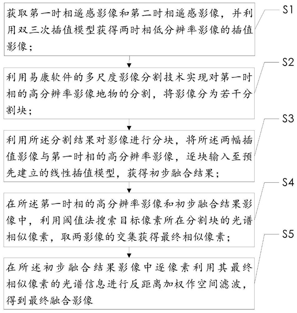
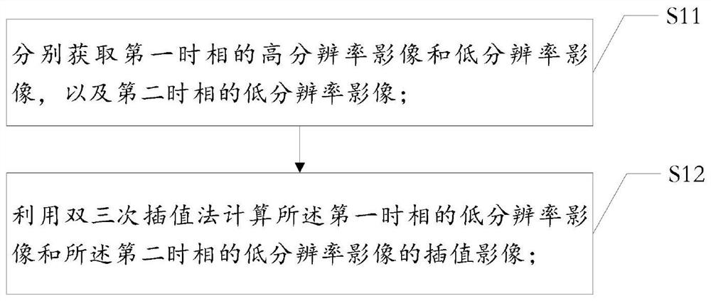
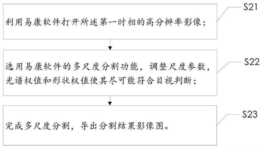
[0069] Embodiments of the application will be further described below in conjunction with the accompanying drawings:

[0070] In recent years, more and more remote sensing satellites have been launched into space. According to different application purposes, the data obtained by different sensors have different temporal, spatial and spectral resolutions. Due to the limitations of sensor hardware conditions, it is difficult to directly obtain remote sensing images with high temporal resolution and high spatial resolution. Each remote sensing data has a certain scope of application and limitations. However, these data can complement each other to expand its ability to observe the Earth. Therefore, how to integrate images from multiple satellites to generate high-quality dense time series data has become an urgent task for high-frequency and high-spatial-resolution observational research. Space-time fusion technology can perform space-time fusion processing on remote sensing ima...


PUM


Abstract

The invention discloses an object-oriented remote sensing image data space-time fusion method, a system and a device, which are suitable for being used in the technical field of remote sensing. The method comprises the following steps: firstly, acquiring a high-resolution image and a low-resolution image of a first time phase and a low-resolution image of a second time phase; downscaling the two time-phase low-spatial-resolution images to the same resolution as the first time-phase high-resolution image by using a bicubic interpolation model to obtain an interpolation image; segmenting the high-resolution image ground object of the first time phase by using image segmentation; in each segmentation block, inputting the interpolation image and a high-resolution image of a first time phase into a pre-established linear interpolation model to obtain a preliminary fusion result; in each segmentation block, searching spectral similar pixels of a target pixel pixel pixel by pixel, and takingan intersection of the two images as a final spectral similar pixel; and performing spatial filtering through inverse distance weighting in combination with spectral similar pixel information, so thata final fused image can be obtained. The steps are simple, and the obtained spatio-temporal data fusion result is better.

Description

technical field [0001] The invention relates to an object-oriented space-time fusion method, system and equipment of remote sensing image data, and is especially suitable for use in the technical field of remote sensing. Background technique [0002] Multi-platform remote sensing satellites provide a large amount of remote sensing data with high spatial and high temporal resolution, providing an important data guarantee for accurate extraction of information such as land cover and dynamic changes. In order to meet some application requirements, dense remote sensing data with high spatial resolution is required. However, due to hardware technology limitations and budget constraints, remote sensing images cannot have both spatial and temporal resolutions. However, there is complementarity between the image information of different sensors, and the space-time fusion technology can be used to generate remote sensing images with both spatial and temporal resolutions without chang...

Claims


Application Information

Patent Timeline
Patent Type & Authority Applications(China)
IPC IPC(8): G06T5/50G06T5/00G06T3/40
CPCG06T3/4023G06T3/4053G06T5/002G06T5/50G06T2207/10032G06T2207/20221
Inventor 张华郝明郭迪洲董荠红史文中
Owner CHINA UNIV OF MINING & TECH
Why Eureka
Try Eureka