Tropical farm planning and management system based on GIS and remote sensing technology

A technology of remote sensing technology and management system, applied in the field of tropical farm planning and management system based on GIS and remote sensing technology, can solve the problems of inability to understand the farm, inability to provide support for farm operation, and inability to maximize planting and harvesting efficiency, etc.

Pending Publication Date: 2021-03-30
海南金垦赛博信息科技有限公司
View PDF0 Cites 2 Cited by
  • Summary
  • Abstract
  • Description
  • Claims
  • Application Information

AI Technical Summary

Problems solved by technology

[0002] In the daily use of farmland and farms, the staff basically plan planting and harvesting based on daily experience, weather, season and other data. The gap in manual experience is large, which is likely to cause planning errors, resulting in planting and harvesting efficiency. The maximum embodiment, and the staff cannot have a

Method used


Image

  • Tropical farm planning and management system based on GIS and remote sensing technology
  • Tropical farm planning and management system based on GIS and remote sensing technology
  • Tropical farm planning and management system based on GIS and remote sensing technology

Examples


Embodiment Construction

[0021] In order to better understand the technical content of the present invention, a specific embodiment is provided below, and the present invention is further described with reference to the accompanying drawings.

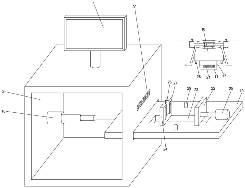
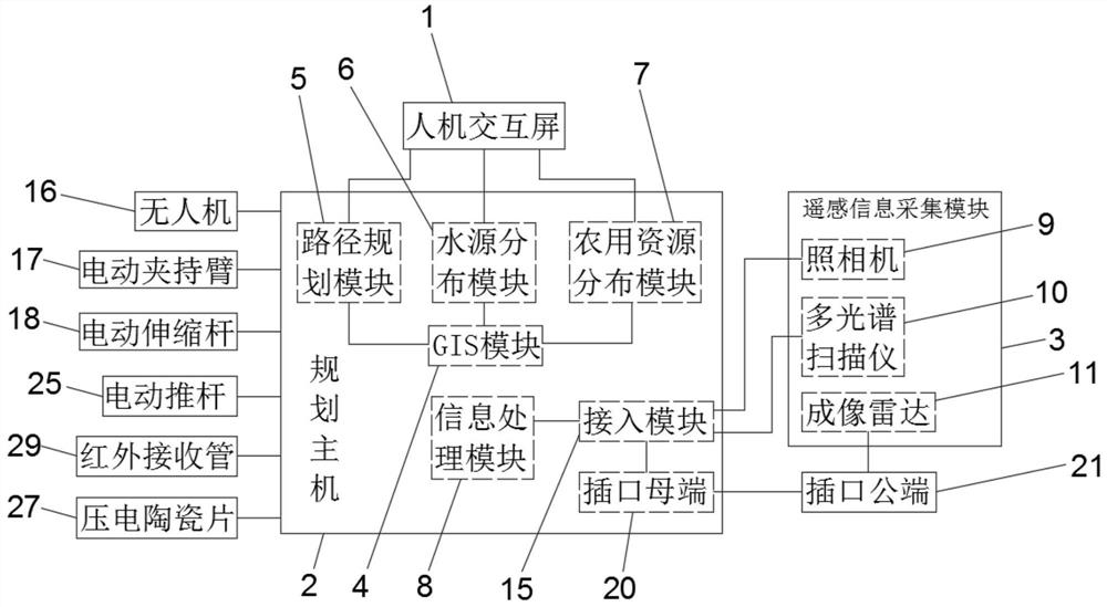
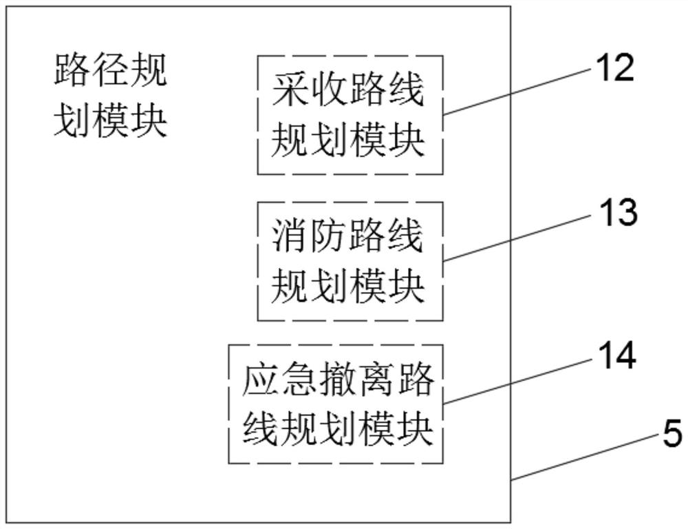
[0022] see Figure 1 to Figure 3 , a tropical farm planning and management system based on GIS and remote sensing technology provided by the present invention includes a human-computer interaction screen 1, a planning host 2 and a remote sensing information collection module 3, and the human-computer interaction screen 1 is arranged above the planning host 2. , and data connection with the planning host 2, the remote sensing information acquisition module 3 is connected with the planning host 2 data; the planning host 2 is internally provided with a GIS module 4, a path planning module 5, a water source distribution module 6, and an agricultural resource distribution module 7 And the information processing module 8, the GIS module 4 is respectively connected wi...


PUM


Abstract

The invention provides a tropical farm planning and management system based on a GIS and a remote sensing technology, and the system comprises a man-machine interaction screen, a planning host, and aremote sensing information collection module; the interior of the planning host is provided with a GIS module, a path planning module, a water source distribution module, an agricultural resource distribution module, and an information processing module; the remote sensing information acquisition module comprises a camera, a multispectral scanner and an imaging radar; the remote sensing information acquisition module acquires terrain, terrain, water source information and the like of a farm, the acquired data is transmitted to the planning host, and the planning host draws a map and superposesall resources according to GIS information. A harvesting route, a fire-fighting route, an emergency evacuation route, a planting route, a sewage drainage route and the like can be planned through thearranged route planning module, comprehensive planning and management of a farm are achieved, and effective utilization of resources and reasonability of crop planting are guaranteed.

Description

technical field [0001] The invention relates, in particular, to a tropical farm planning and management system based on GIS and remote sensing technology. Background technique [0002] In the daily use of farmland, the planning of planting and harvesting is basically carried out by the staff based on daily experience, weather, season and other data. There is a large gap in manual experience, which is easy to cause planning errors, resulting in ineffective planting and harvesting efficiency. The maximum performance, and the staff cannot have a comprehensive understanding of the entire farm, and cannot provide support for farm operations, such as farm terrain, terrain, light, water flow, and outflow reservoirs. The rational planting of crops, the conservation of water resources and the planning of the flow of pollutants cannot be achieved. SUMMARY OF THE INVENTION [0003] In view of this, the present invention proposes a tropical farm planning and management system based o...

Claims


Application Information

Patent Timeline
IPC IPC(8): G06Q10/04G06Q50/02G06F16/29G06F16/248G06F16/2458G06T17/05G01D21/02G16Y10/10G16Y20/10G16Y40/10G16Y40/20
CPCG06Q10/047G06Q50/02G06F16/29G06F16/248G06F16/2462G06T17/05G01D21/02G16Y10/10G16Y20/10G16Y40/10G16Y40/20
Inventor 孙甄李海南蔡淑敏韩君刘鑫陈桂兰王玉香
Owner 海南金垦赛博信息科技有限公司
Why Eureka
Try Eureka