
Unmanned ship route planning method and device based on laser radar recognition algorithm

A technology of laser radar and recognition algorithm, which is applied in radio wave measurement systems, navigation computing tools, instruments, etc., can solve the problems of 3D point cloud data processing difficulties and long processing time, so as to reduce processing difficulty, maintain accuracy, and improve processing efficiency effect

Pending Publication Date: 2021-04-16
WUHAN UNIV OF TECH
View PDF3 Cites 0 Cited by
  • Summary
  • Abstract
  • Description
  • Claims
  • Application Information

AI Technical Summary

Problems solved by technology

However, it is difficult to directly process the 3D point cloud data detected by lidar, and the processing time is long, so the number of point clouds should be reduced in exchange for real-time improvement

Method used


Image

  • Unmanned ship route planning method and device based on laser radar recognition algorithm
  • Unmanned ship route planning method and device based on laser radar recognition algorithm

Examples


Embodiment Construction

[0043] The present invention will be further described below in conjunction with the accompanying drawings and specific embodiments.

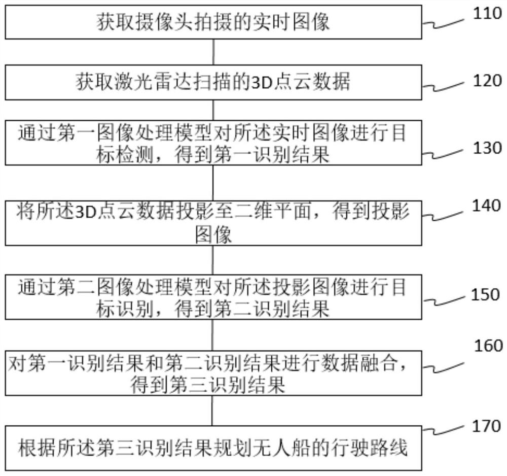
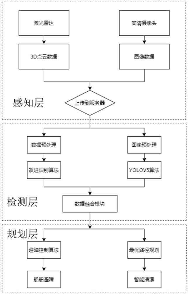
[0044] refer to figure 1 and figure 2 , this embodiment discloses a method for unmanned ship route planning based on the lidar recognition algorithm, by figure 2 implementation of the device shown, it will be appreciated that figure 2 The shown device is just an example, and the method can be realized by devices of other structures, and the method of the present embodiment includes the following steps:

[0045] Step 110, acquiring the real-time image captured by the camera.

[0046] Step 120, acquiring 3D point cloud data scanned by the lidar.

[0047] Specifically, the surrounding environment information is scanned in real time by lidar to build a clear map model.

[0048] Among them, the camera and lidar are installed on the hull, and the camera and lidar collect real-time perception information of the surrounding environment and send...


PUM


Abstract

The invention discloses an unmanned ship route planning method and device based on a laser radar recognition algorithm, and relates to the unmanned ship technology, and the method comprises the following steps: obtaining a real-time image photographed by a camera; acquiring 3D point cloud data scanned by a laser radar; performing target detection on the real-time image through a first image processing model to obtain a first identification result; projecting the 3D point cloud data to a two-dimensional plane to obtain a projection image; performing target identification on the projection image through a second image processing model to obtain a second identification result; performing data fusion on the first identification result and the second identification result to obtain a third identification result; and planning a driving route of the unmanned ship according to the third identification result. According to the scheme, the processing efficiency of the 3D point cloud data is improved, a double-model structure is adopted, the precision of the model is ensured, and powerful data guarantee is provided for real-time route planning of the unmanned ship.

Description

technical field [0001] The invention relates to unmanned ship technology, in particular to a method and device for unmanned ship route planning based on a laser radar recognition algorithm. Background technique [0002] The main theme of the development of today's era is intelligence and unmanned, with the purpose of liberating human productivity and realizing the transformation and development of intelligence in various fields. At the same time, my country's inland waterways are currently seriously polluted, with a large amount of floating debris, which seriously hinders the normal navigation of navigable ships and destroys the normal ecological environment of inland waterways. However, at present, inland waterway cleaning is mainly done manually, which has low efficiency and high costs. Therefore, it is necessary to combine the existing drift cleaning ships with intelligent trends, develop new smart drift cleaning ships, and propose a new decision-making system for smart dr...

Claims


Application Information

Patent Timeline
Patent Type & Authority Applications(China)
IPC IPC(8): G01S7/48G01C21/20
Inventor 马枫王俊毅刘佳仑李诗杰
Owner WUHAN UNIV OF TECH
Learn More