Water and soil conservation measure pattern spot automatic extraction method and system based on deep learning
A technology for soil and water conservation measures and automatic extraction, which is applied in neural learning methods, instruments, biological neural network models, etc.
- Summary
- Abstract
- Description
- Claims
- Application Information
AI Technical Summary
Problems solved by technology
Method used
Image
Examples
Embodiment Construction
[0020] The implementation of the present invention will be described in detail below with reference to the drawings and examples, so as to fully understand and implement the implementation process of how to use technical means to solve technical problems and achieve technical effects in the present invention.
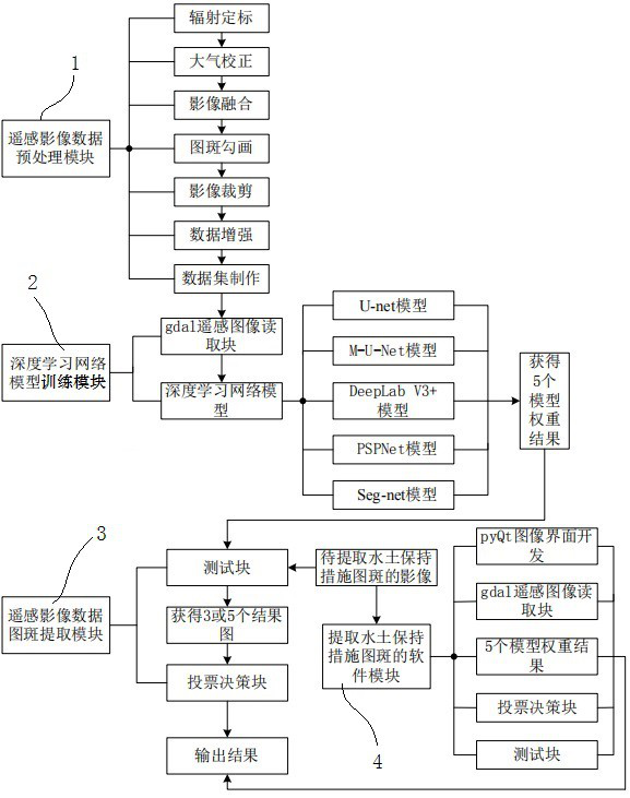
[0021] A method for automatically extracting patterns of water and soil conservation measures based on deep learning, the specific method steps are as follows:
[0022] (1) Preprocessing of remote sensing image data: use ENVI, Arcgis, python and other professional software to complete tasks such as radiometric calibration, atmospheric correction, and image fusion on the downloaded remote sensing images through ENVI software (if UAV remote sensing images This step can be saved); use Arcgis software: first use ArcCatalog to create a shp file, then use ArcMap to outline the points, lines, and planes, and finally vector rasterize to complete the map spot outline. The shp fil...
PUM
 Abstract
Description
Claims
Application Information
 - R&D
- Intellectual Property
- Life Sciences
- Materials
- Tech Scout
- Unparalleled Data Quality
- Higher Quality Content
- 60% Fewer Hallucinations
Browse by: Latest US Patents, China's latest patents, Technical Efficacy Thesaurus, Application Domain, Technology Topic, Popular Technical Reports.
© 2025 PatSnap. All rights reserved.Legal|Privacy policy|Modern Slavery Act Transparency Statement|Sitemap|About US| Contact US: help@patsnap.com


