Intelligent navigation mark system based on edge calculation

An edge computing and navigation aid technology, applied in the field of intelligent navigation aid system, can solve problems such as data leakage, data delay, and high pressure on the cloud, and achieve the effect of improving efficiency, reducing delay, and realizing intelligence

Active Publication Date: 2021-04-16
DALIAN MARITIME UNIVERSITY
View PDF5 Cites 5 Cited by
  • Summary
  • Abstract
  • Description
  • Claims
  • Application Information

AI Technical Summary

Problems solved by technology

[0003] At present, the maritime intelligent navigation mark system mainly sends the collected data to the shore-based server for processing and analysis; this information processing scheme has two obvious defects, one is that the equipment collects all the data and sends it to the cloud for processing and Analysis, due to the rich and huge data at sea, this data processing method will cause excessive pressure on the cloud and cause serious data delay when it is transmitted to a distant cloud
Not only that, when processing rich marine resources in the cloud, it may cause important data leakage, which will have a great impact on the safety of my country's marine navigation. Second, the traditional 3G / 4G communication module is not very good due to the restrictions set by the base station. Applied to the environment of maritime navigation, and the present invention is an intelligent navigation mark based on edge computing, which can solve the problems existing in the above-mentioned prior art by integrating the center of data processing and calculation at the data collection end

Method used


Image

  • Intelligent navigation mark system based on edge calculation
  • Intelligent navigation mark system based on edge calculation
  • Intelligent navigation mark system based on edge calculation

Examples


Embodiment Construction

[0030] In order to make the technical solutions and advantages of the present invention more clear, the technical solutions in the embodiments of the present invention are clearly and completely described below in conjunction with the drawings in the embodiments of the present invention:

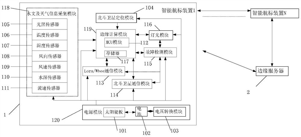
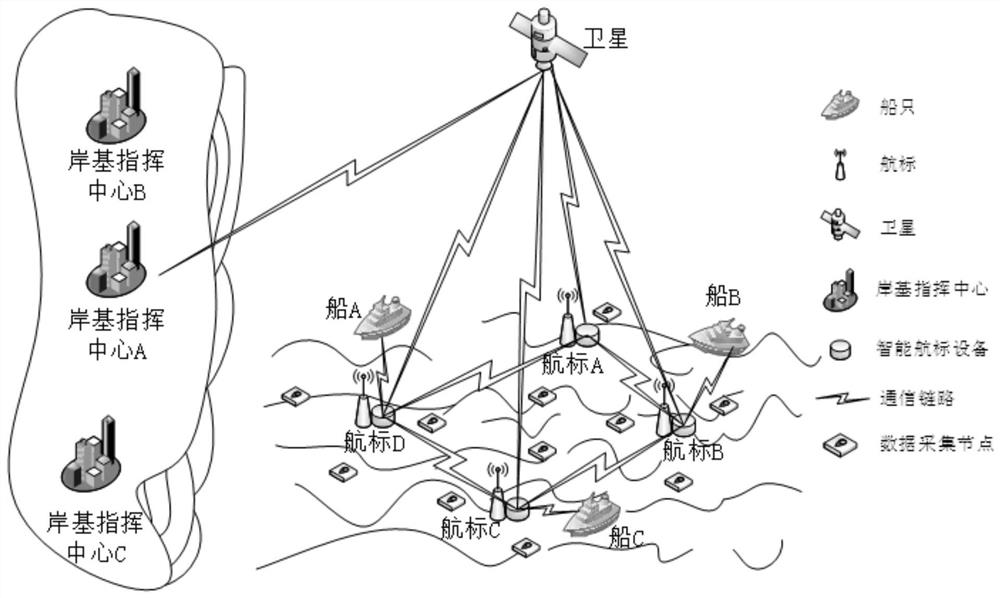
[0031] figure 1 It is a structural diagram of an intelligent navigation aid system based on edge computing; an intelligent navigation aid system based on edge computing provided by the present invention includes N intelligent navigation aid devices 1 and edge servers 2;

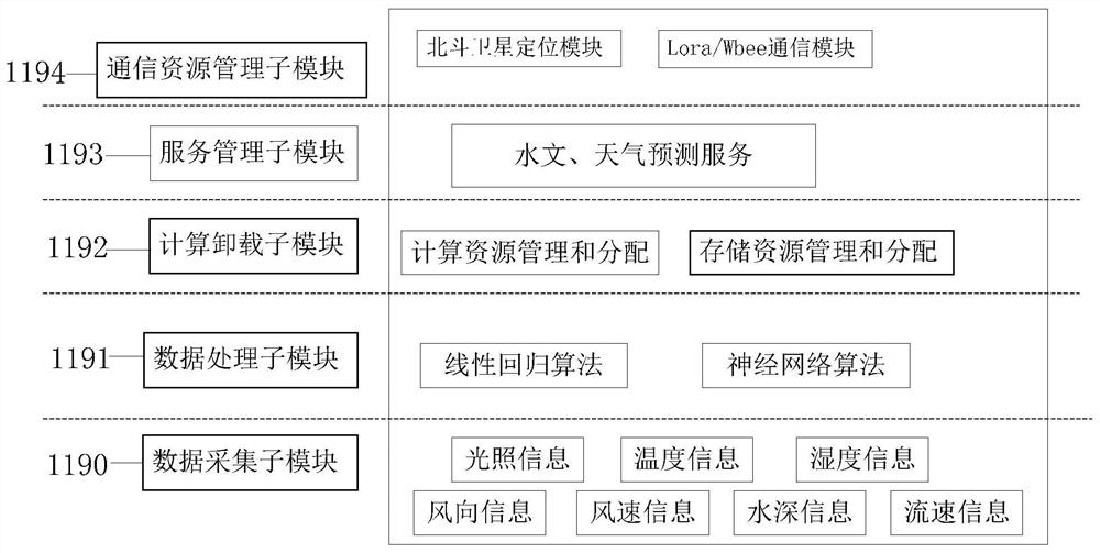
[0032] The intelligent navigation mark device 1 includes a hydrological and weather information collection module 118, a Beidou satellite positioning module 104, an edge computing module 119, a Beidou satellite communication module 114, a Lora / Wbee communication module 113, a power supply module 120, a lighting module 116 and a fault detection module 115;

[0033] The hydrological and weather information collection module 11...


PUM


Abstract

The invention discloses an intelligent navigation mark system based on edge calculation, which belongs to the field of embedding, and comprises N intelligent navigation mark devices and an edge server, the N intelligent navigation mark devices are the same in structure; each intelligent navigation mark device comprises a hydrological and weather information acquisition module and a Beidou satellite positioning module, wherein the hydrological and weather information acquisition module is used for acquiring marine hydrological information and weather information around the navigation mark; the edge calculation module is used for processing the hydrological information and the weather information from the navigation channel to obtain real-time hydrological information and weather information and predicting the weather information of the navigation channel and the change condition of the hydrological information; the edge calculation module comprises a Beidou satellite communication module, a Lora / Wbee communication module and a power module; the edge server processes the hydrological and weather information and the position information to form a channel flow field situation awareness map of a related water area and predict the risk of a channel, and the system completes real-time analysis of hydrology and weather of the whole navigation water area so as to provide a navigation aid decision for ship navigation.

Description

technical field [0001] The invention relates to the embedded field, in particular to an intelligent navigation aid system based on edge computing. Background technique [0002] At present, the current research status of navigation aids is mainly based on a certain communication network marine lighting system. This system will mainly divide the entire navigation aids into two categories, one is a node, and the other is a gateway. The main difference between a node and a gateway is that the gateway's beacon is the data collection center for the surrounding node's beacon, and the gateway's beacon integrates a 3G communication module. The working mode of the whole system is that the node collects some information from the sensor, the node sends the collected information to the gateway through the Zigbee communication module, and the gateway sends the data to the server or the cloud for processing. After the data is processed in the cloud, the data result is sent to To the serve...

Claims


Application Information

Patent Timeline
Patent Type & Authority Applications(China)
IPC IPC(8): H04L29/08H04W4/38G08C17/02H04W4/02H04W4/14B63B22/16G01D21/02H04B7/185
Inventor 林彬傅肖王莹崔昆涛孙璐
Owner DALIAN MARITIME UNIVERSITY
Why Eureka
Try Eureka