Deep-diving long-endurance submersible SINS/DVL ocean current speed estimation method

A technology of ocean current velocity and submersibles, applied in navigation calculation tools, navigation through velocity/acceleration measurement, instruments, etc., can solve problems such as inability to obtain ocean current velocity information

Active Publication Date: 2021-04-30
SOUTHEAST UNIV
View PDF18 Cites 6 Cited by
  • Summary
  • Abstract
  • Description
  • Claims
  • Application Information

AI Technical Summary

Problems solved by technology

This method is based on a specific trajectory movement and is only suitable for the navigation process of the deep-loaded submersible during the dive / surfacing phase, but it cannot provide an effective navigation method for the cruising mission of the deep-diving long-endurance submersible in mid-level waters; and this method cannot obtain ocean current velocity information

Method used


Image

  • Deep-diving long-endurance submersible SINS/DVL ocean current speed estimation method
  • Deep-diving long-endurance submersible SINS/DVL ocean current speed estimation method
  • Deep-diving long-endurance submersible SINS/DVL ocean current speed estimation method

Examples


Embodiment Construction

[0107] Below in conjunction with accompanying drawing and specific embodiment the present invention is described in further detail:

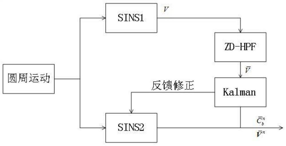
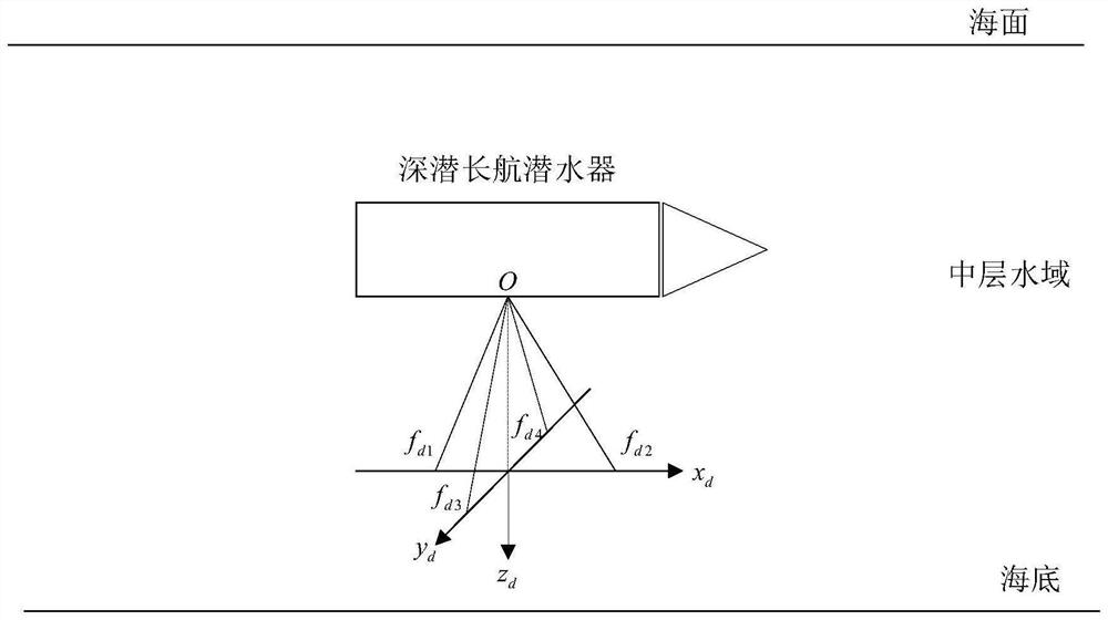
[0108] The invention provides a method for estimating the SINS / DVL ocean current velocity of a deep-diving long-voyage submersible. In view of the lack of navigation information sources in mid-level waters and the difficulty in obtaining ocean current velocity, a method of combining the high-precision navigation information output by SINS self-assisted navigation and the convective velocity obtained by DVL is proposed, and the RLS algorithm is used to realize the estimation of installation error angle and ocean current velocity. method.

[0109] As a specific implementation method of the present invention, the present invention provides a flow chart such as Figure 4 A method for estimating the SINS / DVL ocean current velocity of a deep-diving long-distance submersible is shown, and the specific steps are as follows:

[0110] Step 1: The strapdow...


PUM


Abstract

The invention discloses a deep-diving long-endurance submersible SINS / DVL ocean current speed estimation method which comprises the following steps: 1, performing navigation calculation output twice on the basis of a strapdown inertial navigation system SINS under specific trajectory motion, namely SINS1 and SINS2, designing a high-pass filter to obtain the real horizontal speed of the SINS1, and combining the real horizontal speed with the SINS2 to realize SINS self-aided navigation; 2, according to the Doppler effect principle, the deep diving long-endurance submersible working in the middle-layer water area uses a water tracking mode of a Doppler log DVL to measure the convection velocity; and 3, estimating the ocean current speed by using a least squares estimation algorithm RLS in combination with high-precision navigation parameters provided by SINS self-aided navigation and the convection speed obtained by using DVL. According to the method, the ocean current speed information of the middle-layer water area can be estimated through the SINS / DVL under the conditions that a navigation information source is lacked and the ocean current speed is difficult to obtain in real time.

Description

technical field [0001] The invention belongs to the technical field of underwater navigation and positioning of manned submersibles, and relates to a method for estimating the SINS / DVL ocean current velocity of a deep-diving long-voyage submersible. Background technique [0002] Because of the attenuation characteristics of electromagnetic signals underwater, the global positioning system GPS cannot be used for navigation and positioning in mid-ocean waters. Similarly, the Doppler velocimeter DVL far away from the seabed cannot be directly used for navigation. Navigation information sources are scarce in mid-waters, and only inertial measurement units (IMUs) and acoustic sensors are available. At present, especially for deep submersible long-distance submersibles that perform long-term and long-distance submerged missions at large depths, how to use the scarce navigation information sources in the deep sea to conduct navigation research in mid-level waters has important scie...

Claims


Application Information

Patent Timeline
Patent Type & Authority Applications(China)
IPC IPC(8): G01C21/16G01C21/20
CPCG01C21/165G01C21/203
Inventor 刘锡祥盛广润刘贤俊赵立业黄永江张玉鹏赵苗苗王子璇蒲文浩
Owner SOUTHEAST UNIV
Why Eureka
Try Eureka