Multi-modal data fusion drivable area detection method based on point cloud up-sampling

A driving area, data fusion technology, applied in measurement devices, re-radiation of electromagnetic waves, radio wave measurement systems, etc., can solve the problems of insufficient use of image information, unsuitable road scenes with a structured degree, etc., and achieve rapid growth. Scale aggregation information, fast and accurate detection and segmentation, and the effect of improving accuracy

Pending Publication Date: 2021-04-30
ZHEJIANG UNIV
View PDF0 Cites 3 Cited by
  • Summary
  • Abstract
  • Description
  • Claims
  • Application Information

AI Technical Summary

Problems solved by technology

The defect of this method is that the detection process does not make full use of image information, and it is not suitable for some poorly structured road scenes.

Method used


Image

  • Multi-modal data fusion drivable area detection method based on point cloud up-sampling
  • Multi-modal data fusion drivable area detection method based on point cloud up-sampling
  • Multi-modal data fusion drivable area detection method based on point cloud up-sampling

Examples


Embodiment 1

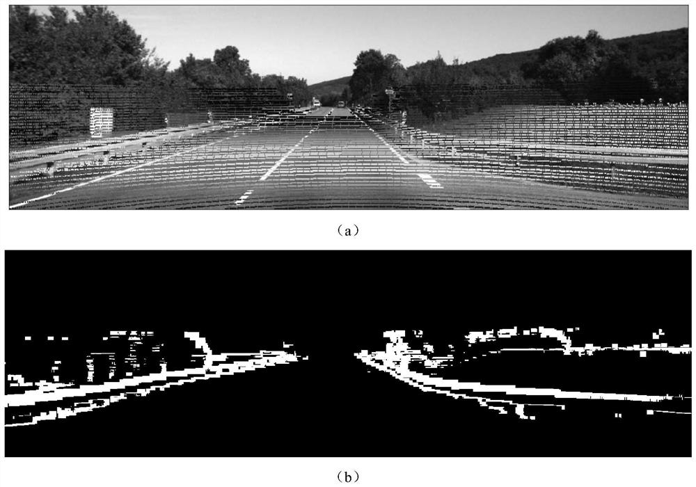
[0051] This embodiment mainly compares the performance indicators of the joint bilateral filtering upsampling algorithm JBU and the adaptive upsampling method based on edge strength information in the present invention. In this embodiment, the depth true value Figure 5 The sparse point cloud image is obtained by downsampling, and the upsampling effect of the two methods is compared. image 3 (a) and (b) represent the JBU upsampling result and the upsampling result of the method of the present invention respectively. It can be found that the method of the present invention can better prevent edge blurring while reducing reconstruction errors.

Embodiment 2

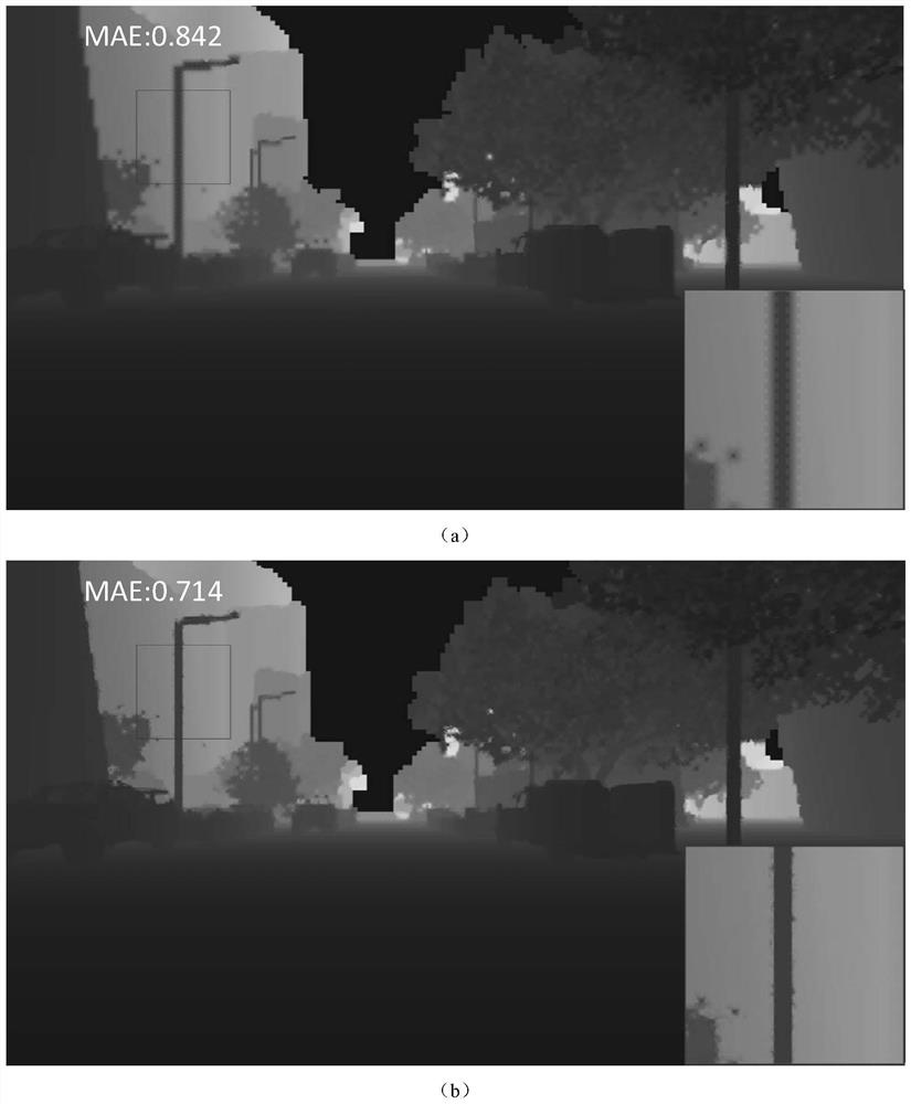
[0053] This example mainly uses the KITTI data set to compare the drivable area detection performance of a single image data network, a single point cloud data network, and a multi-modal data fusion network in the present invention. The detection results of the three networks are as follows: Figure 4 As shown, it can be seen intuitively that the multi-modal data fusion drivable area detection method in the present invention can further improve the accuracy of road detection, avoid false detection of vehicles to a large extent, and at the same time improve the reliability of boundary detection. sex.


PUM


Abstract

The invention discloses a multi-modal data fusion drivable area detection method based on point cloud up-sampling. The method mainly comprises two parts of space point cloud adaptive up-sampling and multi-modal data fusion drivable area detection, and comprises the steps of: registering the camera and the laser radar through a joint calibration algorithm, projecting the point cloud to an image plane to obtain a sparse point cloud graph, calculating edge strength information by using a pixel local window, and adaptively selecting a point cloud up-sampling scheme to obtain a dense point cloud graph; and carrying out feature extraction and cross fusion on the obtained dense point cloud picture and the RGB image to realize rapid detection of a drivable area. The detection method provided by the invention can realize rapid and accurate detection and segmentation of the drivable area.

Description

technical field [0001] The invention relates to a multimodal data fusion drivable area detection method based on point cloud upsampling, which mainly includes two parts: spatial point cloud adaptive upsampling and multimodal data fusion drivable area detection. Background technique [0002] According to the different types of sensors selected, the current drivable area detection algorithms mainly have two schemes based on cameras and based on lidar. Among them, the camera has many advantages such as low cost, high frame rate and high resolution, but it is easily disturbed by factors such as weather, and its robustness is low. On the other hand, lidar mainly acquires data with 3D point cloud. Although it has insufficient resolution and cost, it has high 3D measurement accuracy and strong anti-interference ability, so it is widely used in unmanned systems. general application. For the sparsity of point clouds, some existing methods use the method of joint bilateral filtering...

Claims


Application Information

Patent Timeline
Patent Type & Authority Applications(China)
IPC IPC(8): G01S17/86G01S17/89G01S17/00G01S7/48
CPCG01S7/4802G01S17/006G01S17/89G01S17/86
Inventor 金晓沈会良
Owner ZHEJIANG UNIV
Why Eureka
Try Eureka