Multi-unmanned aerial vehicle four-dimensional track collaborative planning method and system

A multi-UAV, track planning technology, applied in general control system, control/adjustment system, three-dimensional position/course control, etc.

Active Publication Date: 2021-05-18
BEIJING UNION UNIVERSITY
View PDF5 Cites 23 Cited by
  • Summary
  • Abstract
  • Description
  • Claims
  • Application Information

AI Technical Summary

Problems solved by technology

[0006] The purpose of the present invention is to provide a multi-UAV four-dimensional trajectory collaborative planning method and system to solve the optimization problem of how to coordinate time and space to consider the UAV four-dimensional trajectory in the prior art, and the safety problem of UAV operation

Method used


Image

  • Multi-unmanned aerial vehicle four-dimensional track collaborative planning method and system
  • Multi-unmanned aerial vehicle four-dimensional track collaborative planning method and system
  • Multi-unmanned aerial vehicle four-dimensional track collaborative planning method and system

Examples


Embodiment Construction

[0026] The technical solutions of the present invention will be clearly and completely described below in conjunction with the accompanying drawings. Apparently, the described embodiments are some of the embodiments of the present invention, but not all of them. Based on the embodiments of the present invention, all other embodiments obtained by persons of ordinary skill in the art without making creative efforts belong to the protection scope of the present invention.

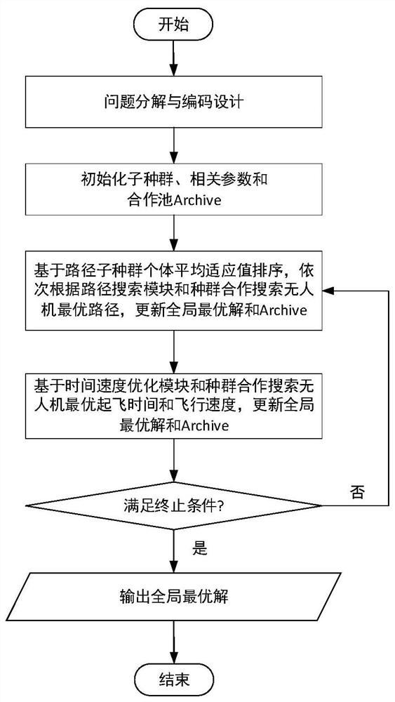
[0027] Figure 1 to Figure 6 A specific embodiment of a multi-UAV four-dimensional trajectory collaborative planning method of the present invention is shown, as Figure 6 shown, including the following steps:

[0028] Step 1: Given the UAV's three-dimensional mission space and mission time range, the take-off location and destination point of multiple UAVs, and the flight time constraint information;

[0029] Step 2: discretize the 3D task space into 3D cuboid grids of equal size, and number the 3D cuboid g...


PUM


Abstract

The invention provides a multi-unmanned aerial vehicle four-dimensional track collaborative planning method and system. The method comprises the following steps: giving unmanned aerial vehicle three-dimensional task space and task time range, take-off sites and destination sites of multiple unmanned aerial vehicles, and flight time constraint information; discretizing the three-dimensional task space into three-dimensional cuboid grids, numbering the three-dimensional cuboid grids, marking the position of the terrain and the position of the threat space in the three-dimensional task space, and abstracting the three-dimensional task space into a directed graph; constructing a single-target multi-unmanned aerial vehicle four-dimensional flight path planning model according to the unmanned aerial vehicle three-dimensional task space and the task time range; and solving the single-target multi-unmanned aerial vehicle four-dimensional route planning model to obtain a planned route, take-off time and flight speed of each unmanned aerial vehicle. Through time optimization, the problem that in a traditional method, only a three-dimensional path is optimized, but time optimization is ignored is solved, the flight path time of the unmanned aerial vehicle is determined better while path planning is carried out, and the utilization rate of space-time resources is increased.

Description

technical field [0001] The invention belongs to the field of UAV path planning, and in particular relates to a multi-UAV four-dimensional trajectory collaborative planning method and system. Background technique [0002] UAV (Unmanned Aerial Vehicle, UAV) was first used in the military field. With the development of modern industrial technology and information technology, UAV presents the characteristics of lightness, flexibility, low price, and convenient deployment. Combining UAV advanced technology and sensor technology, unmanned Machines have been widely expanded to civilian fields, such as aerial photography, communication relay, infrastructure monitoring, traffic monitoring, precision agriculture, search and rescue missions, fire detection, etc., and play an important role in the construction of smart cities. Facing the ever-emerging UAV application requirements and the complexity and diversity of its tasks and environments, it has become a development trend in the fie...

Claims


Application Information

Patent Timeline
Patent Type & Authority Applications(China)
IPC IPC(8): G05D1/10G05B13/04
CPCG05D1/104G05B13/042Y02T10/40
Inventor 肖明明宏晨李克苏利敏江静张宁
Owner BEIJING UNION UNIVERSITY
Why Eureka
Try Eureka