
Navigation method of GNSS/INS integrated navigation system

A technology of integrated navigation system and navigation method, which is applied in the directions of radio wave measurement system, satellite radio beacon positioning system, measurement device, etc., can solve the problem that fisheye camera increases system cost and complexity, reduces filtering accuracy or even diverges, does not have Robustness and other issues, to achieve the effect of good application value, improved robustness and reliability, and low cost

Active Publication Date: 2021-06-11
NAT UNIV OF DEFENSE TECH
View PDF8 Cites 4 Cited by
  • Summary
  • Abstract
  • Description
  • Claims
  • Application Information

AI Technical Summary

Problems solved by technology

When using the above method, the existing problem is: when the GNSS / INS integrated navigation system operates in complex environments such as frequent and short-term satellite signal loss of lock and strong multipath interference, due to the drastic change of GNSS measurement noise and the lack of measurement values, the measurement model Change, the above-mentioned nonlinear fusion filtering method has poor adaptability to sudden changes in the system state quantity, does not have the robustness to deal with the uncertainty of the GNSS / INS integrated navigation system model, and is prone to occur when the noise statistics are unknown or time-varying Filtering accuracy drops or even diverges, resulting in calculation failure
Literature [5] is more complete and accurate than the method of literature [4]. However, the newly added fisheye camera increases the system cost and complexity. At the same time, the fitting formula is also calculated from empirical values. Different sensors Devices, different application scenarios, and different parameters of the fitting formula need to be customized by users, which is not universal

Method used


Image

  • Navigation method of GNSS/INS integrated navigation system
  • Navigation method of GNSS/INS integrated navigation system
  • Navigation method of GNSS/INS integrated navigation system

Examples


Embodiment Construction

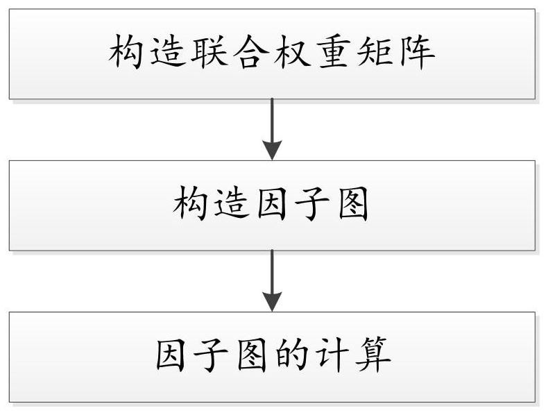
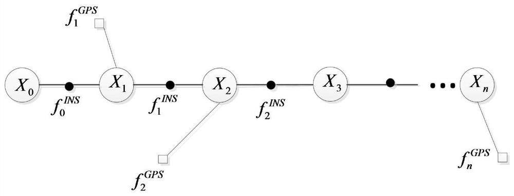
[0015] See the claims for various specific implementation technical solutions provided by the present invention, combined below figure 1 The present invention is further introduced.

[0016] The present invention provides a navigation method of a GNSS / INS integrated navigation system, comprising:

[0017] The first step is to construct the joint weight matrix

[0018] Assume that at a certain moment, after coherent integration of the I branch signal received by the GNSS receiver, the leading branch signal, the immediate branch signal, and the lagging branch signal obtained are respectively I E , I P , I L ; After the Q branch signal is coherently integrated, the leading branch signal, the immediate branch signal and the lagging branch signal are respectively Q E , Q P , Q L .

[0019] Use the following formula to obtain the pseudo-code phase error control amount DLI output by the phase detector as:

[0020]

[0021] Among them, d c is the coherent interval.

[002...


PUM


Abstract

The invention provides a navigation method of a GNSS / INS (Global Navigation Satellite System / Inertial Navigation System) integrated navigation system. The navigation method is applied to the operation of the GNSS / INS integrated navigation system in a tight combination mode. According to the technical scheme, the method comprises the following steps: constructing a joint weight matrix by using a pseudo code tracking loop locking value, a carrier phase tracking loop locking value and a navigation information verification value of a GNSS receiver, and correcting a covariance matrix of a pseudo range measurement value of the GNSS receiver; utilizing the corrected covariance matrix of the pseudo-range measurement value of the GNSS receiver, and obtaining the navigation result of the GNSS / INS integrated navigation system through factor graph calculation. The method is high in navigation precision, does not need to add an additional sensor, has the characteristic of low cost, and has a good application value in engineering practice.

Description

technical field [0001] The invention relates to the technical field of satellite navigation, in particular to a method for using measurement signals to navigate under the tight combination mode of the integrated navigation system of GNSS (Global Navigation Satellite System, global navigation satellite system) and INS (Inertial Navigation System, inertial navigation system). Background technique [0002] With its all-time, global coverage, and high-precision positioning performance, GNSS has become the mainstream navigation method today. However, the GNSS landing signal power is low (about -160dBw), and it is susceptible to various interferences and occlusions. Lower usability is poor, such as urban canyons. With its characteristic of not exchanging information with the outside world, INS just solves the problem that GNSS is susceptible to interference. The GNSS / INS integrated navigation system that combines the above two navigation devices, taking the advantages of both, ha...

Claims


Application Information

Patent Timeline
Patent Type & Authority Applications(China)
IPC IPC(8): G01S19/47
CPCG01S19/47
Inventor 刘小汇袁粤林刘瀛翔于美婷郭海玉王思鑫吴孔阳肖雅木姚闯
Owner NAT UNIV OF DEFENSE TECH
Learn More