Method and system for extracting land and water boundaries of dual-polarized SAR image
A boundary extraction and dual polarization technology, applied in image enhancement, image analysis, image data processing, etc., can solve the problem of not using dual polarization information to the maximum extent, and achieve the effect of high degree of automation and reliable accuracy.
- Summary
- Abstract
- Description
- Claims
- Application Information
AI Technical Summary
Problems solved by technology
Method used
Image

Examples
Embodiment 1
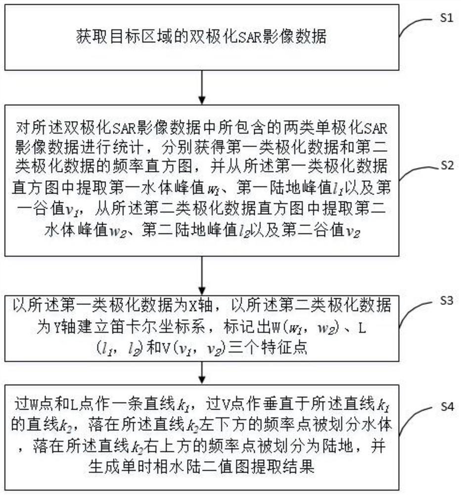
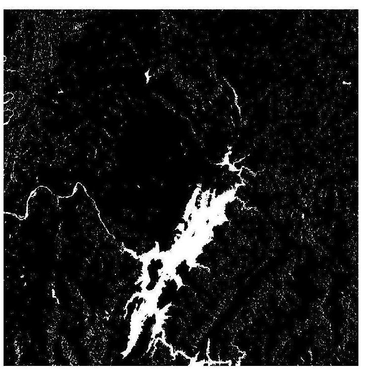
[0041] according to figure 1 As shown, this embodiment proposes a method for extracting water and land boundaries from dual-polarization SAR images, including the following steps:
[0042] S1, acquiring dual-polarization SAR image data of the target area.
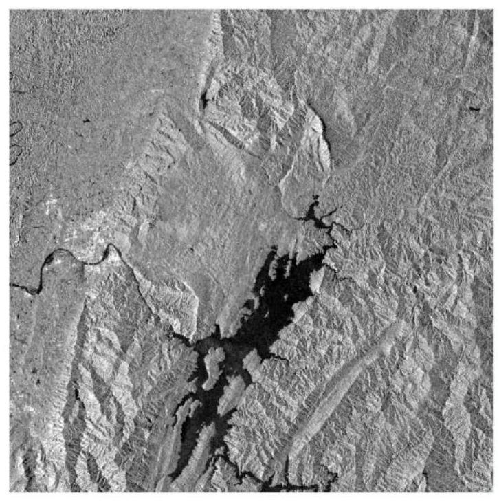
[0043] In this embodiment, the target area is selected as the Dongjiang Lake area in Chenzhou City, Hunan Province, and the dual-polarization data provided by Sentinel-1 is downloaded from the official website of the European Space Agency (ESA) through a PC or any device that can be connected to the Internet. SAR image data, the URL of the dual-polarization SAR image data is https: / / scihub.copernicus.eu / dhus / # / home, the time stamp of the dual-polarization SAR image data file is December 9, 2020, and the file name It is S1A_IW_GRDH_1SDV_20201209T103450_20201209T103515_035608_042A35_8945.zip, the product type is GRD, and this type of product has two polarization modes of VV and VH.
[0044] Furthermore, after obtaining the ...
Embodiment 2
[0062]The three water and land boundary extraction methods described in the background art cannot deal with the impact of shadows on water bodies well. The existence of mountains or tall buildings, as well as the characteristics of satellite remote sensing oblique photogrammetry, may cause more shadows on optical or radar images. How to remove the interference of shadow noise as much as possible on the basis of water body extraction has always troubled people. problem. Because the imaging methods and imaging mechanisms of optical satellites and radar satellites are very different, specifically, optical satellites are passive remote sensing, which records the reflectivity of ground objects to solar radiation. Radar satellites belong to active remote sensing, which records the backscatter coefficient of ground objects on the active radiation emitted by radar. Different satellites have different imaging positions and observation directions at different times, and the relative az...
Embodiment 3
[0070] like Figure 5 As shown, a water and land boundary extraction system for dual-polarization SAR images is disclosed, including:
[0071] A data acquisition device, configured to acquire dual-polarization SAR image data of the target area;
[0072] The data analysis device is used to perform statistics on the two types of single-polarization SAR image data contained in the dual-polarization SAR image data, respectively obtain the frequency histograms of the first type of polarization data and the second type of polarization data, and obtain from Extract the first water body peak w from the frequency histogram of the first type of polarization data 1 , the first land peak l 1 and the first valley v 1 , extract the second water body peak value w from the frequency histogram of the second type of polarization data 2 , the second land peak l 2 and the second valley v 2 ;
[0073] The data modeling device is used to establish a Cartesian coordinate system with the first...
PUM
 Abstract
Description
Claims
Application Information
 - R&D
- Intellectual Property
- Life Sciences
- Materials
- Tech Scout
- Unparalleled Data Quality
- Higher Quality Content
- 60% Fewer Hallucinations
Browse by: Latest US Patents, China's latest patents, Technical Efficacy Thesaurus, Application Domain, Technology Topic, Popular Technical Reports.
© 2025 PatSnap. All rights reserved.Legal|Privacy policy|Modern Slavery Act Transparency Statement|Sitemap|About US| Contact US: help@patsnap.com