Weighted positioning method based on GNSS signal accurate classification in urban canyon

An urban canyon and positioning method technology, which is applied in the field of satellite positioning and navigation, can solve problems such as unreasonable assumptions, unreasonable weight models, and impact on subsequent training accuracy and positioning accuracy.

Pending Publication Date: 2021-06-25
NANJING UNIV OF AERONAUTICS & ASTRONAUTICS
View PDF0 Cites 1 Cited by
  • Summary
  • Abstract
  • Description
  • Claims
  • Application Information

AI Technical Summary

Problems solved by technology

This method considers signal propagation, reflection, diffraction and other issues too simply. It is considered that the GNSS signal wave propagation is simply along a straight line, and the assumption is not reasonable enough, which leads to insufficient calibration accuracy of the GNSS signal receiving type.
Thus seriously affecting the accuracy of subsequent training and the final positioning accuracy
[0006] At the same time, in the existing research, in the weighted positioning solution for the signal reception type (Multipath, NLOS), the consideration of the weight setting is not comprehensive and reasonable. Usually, only a single carrier-to-noise ratio and satellite elevation angle are considered. factors, the weight model is not reasonable enough

Method used


Image

  • Weighted positioning method based on GNSS signal accurate classification in urban canyon
  • Weighted positioning method based on GNSS signal accurate classification in urban canyon
  • Weighted positioning method based on GNSS signal accurate classification in urban canyon

Examples


Embodiment Construction

[0043] Embodiments of the present invention will be described below with reference to the accompanying drawings.

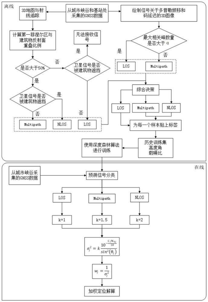
[0044] A flow chart of a weighted positioning method based on precise classification of GNSS signals in an urban canyon figure 1 As shown, it includes the following three stages.

[0045] (1) Establish a historical training data set

[0046] Collect GNSS data from the base station and the urban canyon respectively, and use the carrier-to-noise ratio and satellite elevation angle to form a historical training data set. Each sample in the data set contains two variables (C / N 0 , θ). And the signal is divided into LOS / NLOS / Multipath, marked, and the marked historical training data set is obtained.

[0047] The present invention uses comprehensive decision-making to mark the signal type, which is divided into the following three steps:

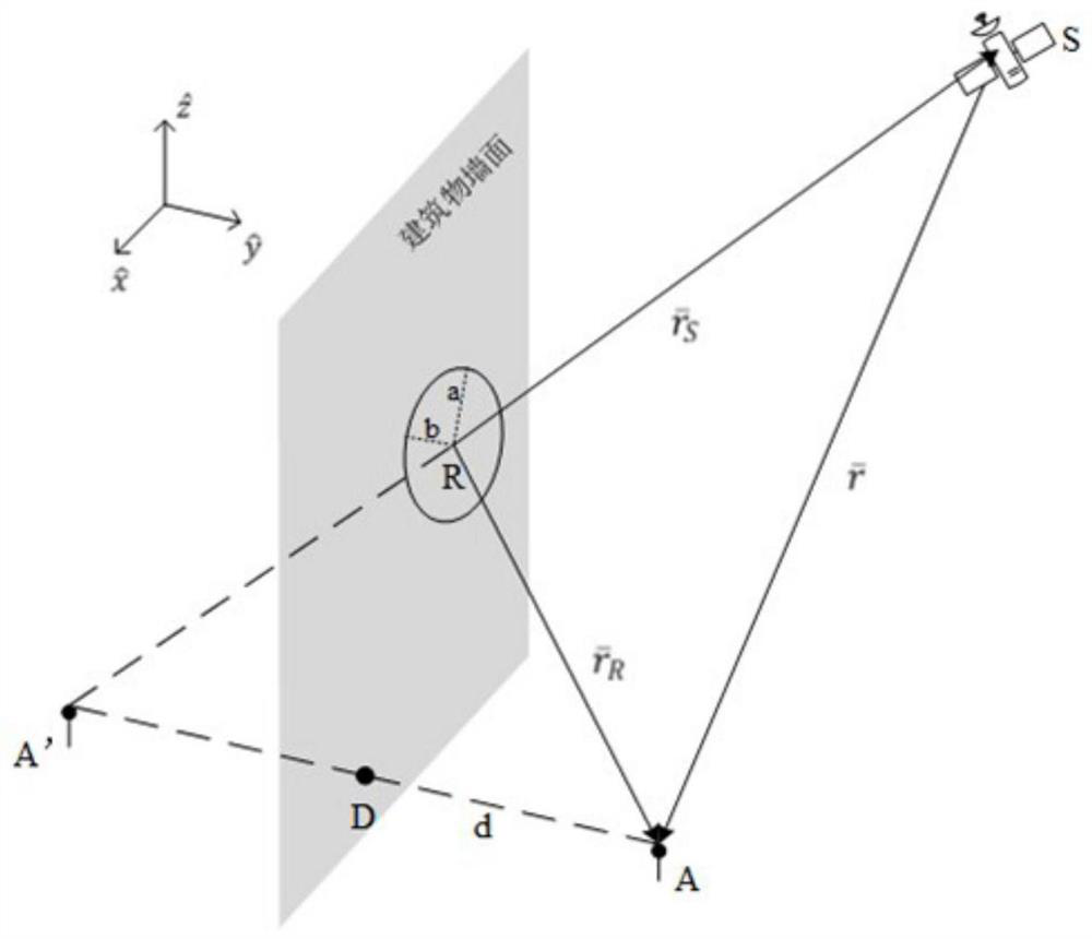
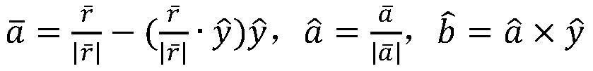
[0048] Step 1.1: Use the Fresnel zone to judge the type of signal reception

[0049] The invention adopts an improved ray traci...


PUM


Abstract

The invention discloses a weighted positioning method based on GNSS signal accurate classification in an urban canyon, which belongs to the field of satellite positioning and navigation. The method comprises the following steps of 1, establishing a historical training data set, acquiring GNSS data from a base station and an urban canyon, calibrating a satellite signal receiving type by combining the GNSS data, forming a historical training data set by the carrier-to-noise ratio C/N0 of the satellite signal, the elevation angle theta of the satellite and the receiving type of the satellite signal, 2, mining the historical training data set by adopting a machine learning algorithm deep forest, and generating a satellite signal receiving type judgment rule, and 3, acquiring GNSS data from the urban canyon, predicting a satellite signal receiving type by using a depth forest, and performing positioning calculation in combination with weighted least squares. According to the method, precise classification of GNSS signal receiving types is realized, and the positioning precision is effectively improved by combining weighted positioning calculation considering the carrier-to-noise ratio, the satellite elevation angle and the signal receiving types.

Description

technical field [0001] The invention belongs to the field of satellite positioning and navigation, in particular to a weighted positioning method based on precise classification of GNSS signals in urban canyons. Background technique [0002] The development of smart cities has promoted the vigorous development of location-based service applications. Location-based services in cities include applications such as smart transportation, smart medical positioning, and logistics monitoring. Navigation and positioning technology can provide important support for location services in the urban environment by obtaining the real-time position, speed and time information of the carrier. Global navigation satellite system (GNSS) is an important sensor of navigation and positioning technology. Its signals will generate non-line-of-sight (NLOS) signals and multipath (multipath) signals in urban environments due to the occlusion of buildings. )Signal. NLOS and Multipath signals can caus...

Claims


Application Information

Patent Timeline
Patent Type & Authority Applications(China)
IPC IPC(8): G01S19/37G06K9/62G06N3/04
CPCG01S19/37G06N3/045G06F18/2411G06F18/24323G06F18/214
Inventor 孙蕊张紫璇林挺
Owner NANJING UNIV OF AERONAUTICS & ASTRONAUTICS
Why Eureka
Try Eureka