Remote charting mapping method and device for karst rocky desertification

A rocky desertification and karst technology, applied in the field of geographic information images, can solve problems such as the uncertainty of rocky desertification classification and the difference in rocky desertification classification results

Active Publication Date: 2021-07-06
INST OF GEOGRAPHICAL SCI & NATURAL RESOURCE RES CAS
View PDF7 Cites 4 Cited by
  • Summary
  • Abstract
  • Description
  • Claims
  • Application Information

AI Technical Summary

Problems solved by technology

At present, there is no unified rule to draw the cartographic units, and the different sizes of the research units often lead to differences in the classification results of rocky desertification, which makes the classification of rocky desertification more uncertain.

Method used


Image

  • Remote charting mapping method and device for karst rocky desertification
  • Remote charting mapping method and device for karst rocky desertification
  • Remote charting mapping method and device for karst rocky desertification

Examples


Embodiment Construction

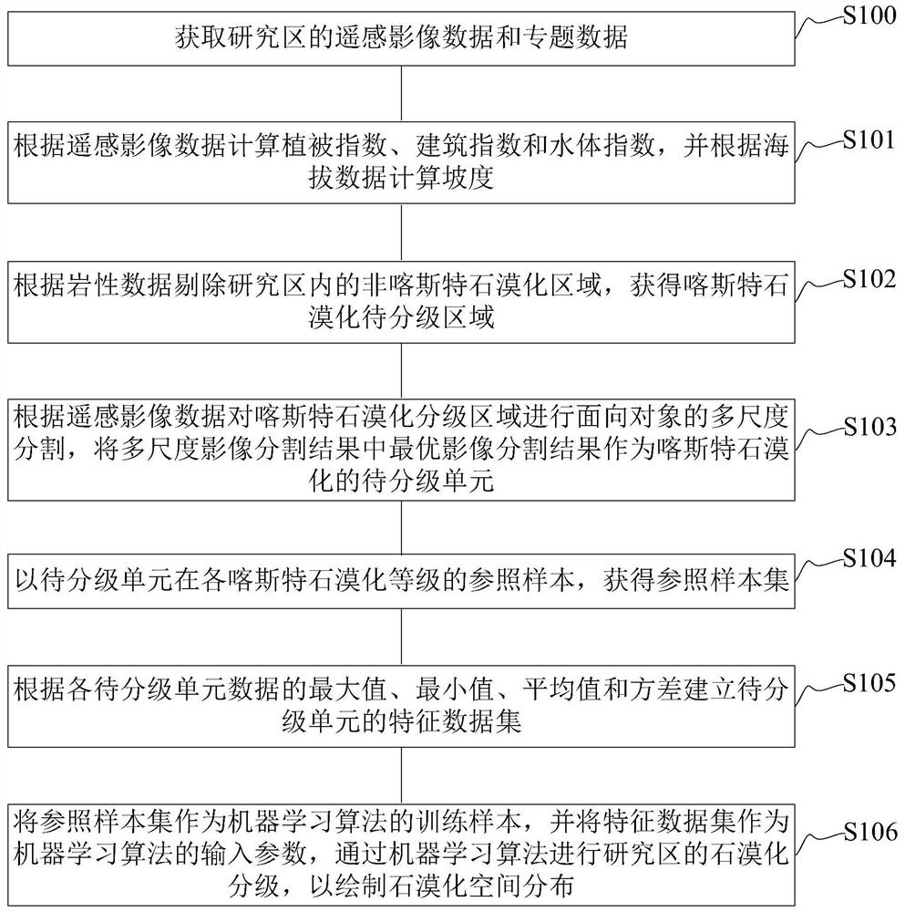
[0059] In order to better understand the purpose, technical solution and technical effect of the present invention, the present invention will be further explained below in conjunction with the accompanying drawings and embodiments. At the same time, it is stated that the embodiments described below are only used to explain the present invention, and are not intended to limit the present invention.

[0060] An embodiment of the present invention provides a remote sensing mapping method for karst rocky desertification.

[0061] figure 1 It is a flow chart of the remote sensing mapping method of karst rocky desertification in one embodiment, as figure 1 As shown, the remote sensing mapping method of karst rocky desertification in an embodiment includes steps S100 to S106:

[0062] S100, obtaining remote sensing image data and thematic data of the research area; wherein, the thematic data includes lithology data, elevation data and land use data;

[0063] The study area is the...


PUM


Abstract

The invention relates to a remote sensing charting method and device for karst rocky desertification, which effectively depicts and extracts information reflecting karst rocky desertification characteristics through remote sensing image data and thematic data so as to improve the recognition capability of a machine learning algorithm on each rocky desertification level. Meanwhile, the rocky desertification units are defined by adopting an object-oriented strategy, so that automatic drawing of the to-be-graded units of the karst rocky desertification is realized, and the rocky desertification drawing units are outlined. On the basis, karst rocky desertification mapping can be rapidly achieved through a small amount of sample data, the mapping precision and efficiency are improved, and meanwhile the advantages of being high in automation degree and transportability are achieved.

Description

technical field [0001] The invention relates to the technical field of geographic information images, in particular to a remote sensing mapping method and device for karst rocky desertification. Background technique [0002] As a special type of land desertification, karst rocky desertification is a major economic, ecological and environmental problem worldwide, threatening the sustainable development of society. Quickly and accurately mapping the spatial distribution of regional karst rocky desertification can effectively realize the dynamic monitoring of rocky desertification and assist in the formulation and effect evaluation of rocky desertification control measures. Remote sensing images have become an important source of large-scale spatial mapping of rocky desertification. Since the visual interpretation technology used in previous studies is time-consuming and laborious, it is of great significance to use automatic and semi-automatic recognition methods for high-prec...

Claims


Application Information

Patent Timeline
Patent Type & Authority Applications(China)
IPC IPC(8): G06K9/00G06K9/34G06K9/62G06F16/29G06N3/04G06N20/00
CPCG06F16/29G06N3/04G06N20/00G06V20/176G06V20/188G06V10/267G06F18/214G06F18/241
Inventor 许尔琪
Owner INST OF GEOGRAPHICAL SCI & NATURAL RESOURCE RES CAS
Why Eureka
Try Eureka