Method for establishing wide-area and local-area fused high-precision ionospheric scintillation model

An ionospheric, high-precision technology, applied in the field of satellite navigation, can solve problems such as large ionospheric scintillation prediction errors, and achieve the effects of overcoming the discontinuity of space-based observations, improving performance, and improving accuracy

Active Publication Date: 2021-07-09
BEIHANG UNIV
View PDF6 Cites 2 Cited by
  • Summary
  • Abstract
  • Description
  • Claims
  • Application Information

AI Technical Summary

Problems solved by technology

[0008] Therefore, in order to solve the problem of large ionospheric scintillation prediction errors in the prior art, a high-precision ionospheric scintillation model establishment method with wide-area and local fusion is needed

Method used


Image

  • Method for establishing wide-area and local-area fused high-precision ionospheric scintillation model
  • Method for establishing wide-area and local-area fused high-precision ionospheric scintillation model
  • Method for establishing wide-area and local-area fused high-precision ionospheric scintillation model

Examples


Embodiment Construction

[0084] The objects and functions of the present invention and methods for achieving the objects and functions will be clarified by referring to the exemplary embodiments. However, the present invention is not limited to the exemplary embodiments disclosed below; it can be implemented in various forms. The essence of the description is only to help those skilled in the relevant art comprehensively understand the specific details of the present invention.

[0085] Hereinafter, embodiments of the present invention will be described with reference to the accompanying drawings. In the drawings, the same reference numerals represent the same or similar components, or the same or similar steps.

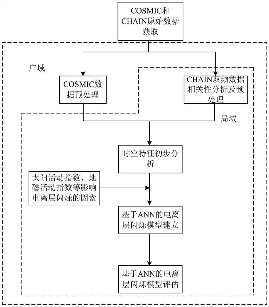
[0086] In order to solve the problems existing in the prior art, the present invention performs data preprocessing on the ionospheric scintillation index, and removes abnormal values ​​from a large amount of historical observation data; analyzes the correlation of the CHAIN ​​dual-frequency...


PUM


Abstract

The invention provides a method for establishing a wide-area and local-area fused high-precision ionospheric scintillation model, which comprises the following steps of: a) acquiring original signal data of an air-based COSMIC satellite and a high-latitude area foundation CHAIN observation station, and preprocessing the acquired original signal data; b) performing spatial-temporal characteristic preliminary analysis on the acquired ionospheric scintillation signal data; (c) establishing a wide-area ionospheric scintillation ANN model; (d) testing the wide-area ionospheric scintillation ANN model; (e) establishing a high-latitude polar region local ionospheric scintillation ANN model; and (f) testing the high-latitude polar region local ionospheric scintillation ANN model. According to the method, two kinds of observation data of COSMIC and CHAIN are utilized, the ionospheric scintillation occurrence condition model is represented in the form of the time change rate index ROTI of the total electron content, and the ionospheric scintillation model in the high-latitude region is established by independently using CHAIN station data, so that wide-area and local-area fusion is achieved, the receiver performance is improved, and the satellite navigation positioning precision is improved.

Description

technical field [0001] The invention relates to the technical field of satellite navigation, in particular to a method for establishing a high-precision ionospheric scintillation model with wide-area and local-area fusion. Background technique [0002] many [0003] The ionosphere is a part of the Earth's atmosphere, the area above 60 km above the Earth's surface. Molecules and atoms in the atmosphere of this region are partially ionized by solar radiation (mainly ultraviolet radiation and X-rays), and there are a large number of positive ions and free electrons. The American Institute of Electrical and Electronics Engineers standard (1969) defines the ionosphere according to the angle at which radio waves are affected: "The part of the Earth's atmosphere in which the number of ions and electrons present is sufficient to affect the propagation of radio waves". [0004] With the rapid development of the global satellite navigation system, the ionosphere has become a necessa...

Claims


Application Information

Patent Timeline
IPC IPC(8): G01S19/07
CPCG01S19/072Y02A90/10
Inventor 王成樊涵东李可薛开宇
Owner BEIHANG UNIV
Why Eureka
Try Eureka