Unsupervised remote sensing image semantic segmentation method based on super-resolution and domain self-adaption

A super-resolution, remote sensing image technology, applied in image analysis, image enhancement, image data processing, etc., can solve the problems of pixel-level positioning information loss, unbalanced types, etc., to avoid explosion and disappearance, strong robustness, The effect of alleviating the category imbalance problem

Active Publication Date: 2021-07-23
中国建筑材料工业地质勘查中心山西总队
View PDF7 Cites 9 Cited by
  • Summary
  • Abstract
  • Description
  • Claims
  • Application Information

AI Technical Summary

Problems solved by technology

This model uses the Atrous Spatial Pyramid Pooling Module to extract multi-scale features or scale-invariant features, but Dilated Convolution is a kind of sparse calculation that may cause grid artifacts (Grid Artifacts ); while the spatial pyramid pooling module may cause loss of pixel-level positioning information
In addition, the semantic segmentation of high-resolution remote sensing images often faces the problem of serious category imbalance.

Method used


Image

  • Unsupervised remote sensing image semantic segmentation method based on super-resolution and domain self-adaption
  • Unsupervised remote sensing image semantic segmentation method based on super-resolution and domain self-adaption
  • Unsupervised remote sensing image semantic segmentation method based on super-resolution and domain self-adaption

Examples


Embodiment Construction

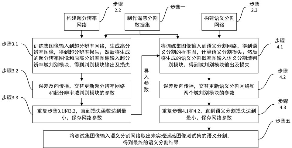
[0091] like Figure 1 to Figure 9 As shown, the present invention based on super-resolution and domain adaptive unsupervised remote sensing image semantic segmentation method replaces the ASPP module in the original super-resolution domain adaptive unsupervised remote sensing image semantic segmentation method through the feature pyramid attention module, and the residual The difference feature pyramid attention module is applied to the discriminator to obtain accurate pixel-level attention for high-level semantic features; the problem of category imbalance is alleviated through the Dice coefficient loss function, which includes the following steps:

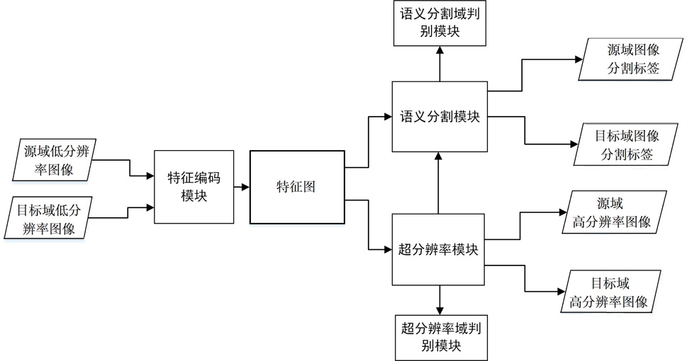
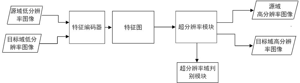
[0092] Step 1: Obtain a low-resolution remote sensing image dataset in the source domain and a high-resolution remote sensing image dataset in the target domain. The source domain and target domain remote sensing image datasets are obtained through remote sensing satellites; the source domain data includes low-resolution original ...


PUM


Abstract

The invention discloses an unsupervised remote sensing image semantic segmentation method based on super-resolution and domain self-adaption, and belongs to the technical field of remote sensing image semantic segmentation methods. The technical problem to be solved is to provide the improvement of the unsupervised remote sensing image semantic segmentation method based on super-resolution and domain self-adaption. According to the technical scheme, the method comprises the following steps: obtaining a source domain low-resolution remote sensing image data set and a target domain high-resolution remote sensing image data set, and dividing the obtained target domain image data set into a training image and a test image according to a set proportion; building a remote sensing image semantic segmentation network and a super-resolution network; carrying out network pre-training and parameter optimization on the built super-resolution network; training a remote sensing image semantic segmentation network; inputting the preprocessed test set data into the trained remote sensing image semantic segmentation network, and outputting an accurate segmentation result of the remote sensing image; the invention is applied to remote sensing image processing.

Description

technical field [0001] The invention relates to an improved unsupervised high-resolution remote sensing image semantic segmentation method based on super-resolution and domain self-adaptation, and belongs to the technical field of remote sensing image semantic segmentation methods. Background technique [0002] In recent years, with the continuous advancement and wide application of high-resolution earth observation technology, the spatial resolution of high-resolution remote sensing data has been continuously improved and accumulated geometrically. Therefore, how to automatically, quickly and accurately extract High-value geographic information has become one of the important problems that need to be solved urgently. Semantic segmentation marks each pixel in the image as a specific type of feature, also known as feature extraction or land classification, is one of the important means of information extraction from high-resolution remote sensing images, and is widely used in...

Claims


Application Information

Patent Timeline
Patent Type & Authority Applications(China)
IPC IPC(8): G06T7/10G06T3/40G06T5/50G06N3/04G06N3/08
CPCG06T7/10G06T3/4053G06T5/50G06N3/08G06T2207/10032G06T2207/20081G06T2207/20084G06T2207/20132G06N3/045
Inventor 郭学俊陈泽华杨佳林刘晓峰赵哲峰杨莹张佳鹏
Owner 中国建筑材料工业地质勘查中心山西总队
Why Eureka
Try Eureka