Method for generating feasible region label based on laser radar

A technology of lidar and passing area, applied in the field of deep neural network, can solve the problems of time-consuming, labor-intensive, high labor cost, etc., and achieve the effect of reducing cost

Active Publication Date: 2021-08-06
ZHEJIANG UNIV
View PDF8 Cites 0 Cited by
  • Summary
  • Abstract
  • Description
  • Claims
  • Application Information

AI Technical Summary

Problems solved by technology

[0004] However, in the field of detecting road passable areas, it is time-consuming and

Method used


Image

  • Method for generating feasible region label based on laser radar
  • Method for generating feasible region label based on laser radar
  • Method for generating feasible region label based on laser radar

Examples


Embodiment Construction

[0046] The technical solution of the present invention will be further described below in conjunction with the accompanying drawings and specific embodiments:

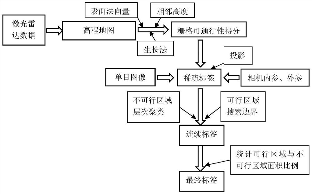
[0047] figure 1 It is a schematic flow chart of the method for generating a passable area label based on laser radar in the present invention. The present invention discloses a method for generating a passable area label based on laser radar, which includes the following steps:

[0048] Obtain lidar data and monocular camera images of the robot;

[0049] Build an elevation map based on current lidar data;

[0050] Calculate the raster's traversability score based on the height information of each raster on the elevation map;

[0051] According to the external parameter and internal parameter matrix of the monocular camera, the feasibility score of each grid on the elevation map is mapped to the image, and the monocular image with sparse grid information is obtained.

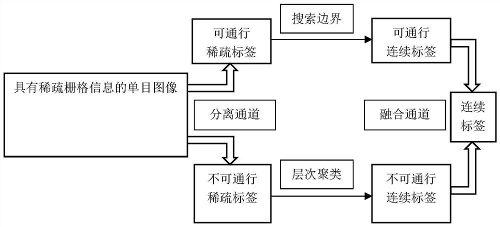
[0052] Based on monocular images with sparse raste...


PUM


Abstract

The invention discloses a method for generating a feasible area label based on a laser radar. The method comprises the steps: obtaining laser radar data of a robot and a monocular camera image, constructing an elevation map according to the current laser radar data, calculating the trafficability score of each grid according to the height information of each grid on the elevation map, and mapping the passability score of each grid on the elevation map to the image according to the external and internal parameter matrixes of the monocular camera, obtaining continuous passable and impassable region labels by combining clustering and search algorithms in machine learning, and obtaining high-quality labels through an automatic screening framework. The method can be suitable for many public data sets without labels, a huge-scale data set with labels is generated, the cost of network training is greatly reduced, fusion use of sensors and combined use of multiple methods are achieved, the advantages of all the methods are brought into full play in the algorithm, and therefore the effects of improving the label quality and reducing the label cost are achieved.

Description

technical field [0001] The present invention relates to deep neural network technology, in particular to a laser radar-based feasible region label generation method. Background technique [0002] Real-time perception of the local environment is the basis for autonomous navigation of robots, and an elevation map is a commonly used map model to describe the local environment. The elevation map is constructed from the visual information obtained by the various sensors equipped with the robot, and is updated with the pose transformation of the robot. [0003] At present, the performance of the method of constructing the elevation map of the local environment based on vision needs to be improved, and the intermediate steps need to be simplified. Many studies expect to hide the intermediate steps in the neural network model through deep learning to improve the efficiency and performance of the system. In recent years, deep neural networks have enabled the rapid development of th...

Claims


Application Information

Patent Timeline
IPC IPC(8): G06K9/62G06T7/73
CPCG06T7/73G06T2207/10044G06T2207/10024G06T2207/30256G06T2207/20081G06T2207/20084G06F18/2321G06F18/25Y02A90/10
Inventor 王越陆俊元朱承睿
Owner ZHEJIANG UNIV
Why Eureka
Try Eureka