Hyperspectral and multispectral remote sensing information fusion method and system

A hyperspectral remote sensing and fusion method technology, applied in the field of remote sensing image fusion, can solve the problems that fusion algorithms are not suitable for hyperspectral image characteristics, remote sensing images cannot be quantitatively processed, lack of physical models and knowledge bases, etc., and achieve good data quality, The effect of increasing reliability and improving classification accuracy

Pending Publication Date: 2021-08-06
自然资源部国土卫星遥感应用中心
View PDF0 Cites 3 Cited by
  • Summary
  • Abstract
  • Description
  • Claims
  • Application Information

AI Technical Summary

Problems solved by technology

[0010] Existing remote sensing image fusion technology methods are not suitable for remote sensing image fusion processing involving hyperspectral images. The existing problems are as follows: (1) Lack of rigorous physical models and knowledge bases, using mathematical models and functions to realize the superposition of various information , so that the fusion algorithm is not suitable for the characteristics of hyperspectral images; (2) the existing fusion algorithm causes the distortion of the spectral information of the remote sensing image, breaking the physical law of the surface reflectance contained in the remote sensing image, and thus makes the remote sensing image unable to carry out more in-depth quantitative Significant negative effects of remote sensing processing

Method used


Image

  • Hyperspectral and multispectral remote sensing information fusion method and system
  • Hyperspectral and multispectral remote sensing information fusion method and system
  • Hyperspectral and multispectral remote sensing information fusion method and system

Examples


Embodiment Construction

[0042] In order to make the purpose, technical solutions and advantages of the embodiments of the present invention more clear, the following will clearly and completely describe the technical solutions of the embodiments of the present invention in conjunction with the drawings of the embodiments of the present invention. Apparently, the described embodiments are some, not all, embodiments of the present invention. All other embodiments obtained by those skilled in the art based on the described embodiments of the present invention belong to the protection scope of the present invention.

[0043] The present invention will be described in detail below in conjunction with the accompanying drawings and embodiments.

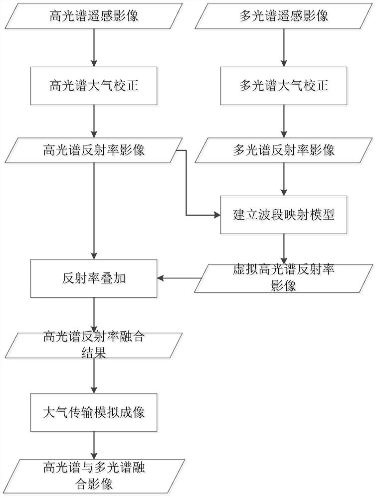
[0044] Such as figure 1 As shown, the present invention provides a hyperspectral and multispectral remote sensing information fusion method, which includes:

[0045] Step (1), performing hyperspectral atmospheric correction according to pre-acquired hyperspectral...


PUM


Abstract

The invention relates to a hyperspectral and multispectral remote sensing information fusion method and system. The method comprises the following steps: performing hyperspectral atmospheric correction according to pre-acquired hyperspectral remote sensing image data; carrying out multispectral atmospheric correction according to multispectral remote sensing image data acquired in advance; establishing a wave band mapping model based on a hyperspectral reflectivity image result and a multispectral reflectivity image result of the earth surface generated after hyperspectral atmospheric correction and multispectral atmospheric correction; carrying out weighted calculation of the spectral reflectivity value on the virtual hyperspectral reflectivity image result by taking the original hyperspectral reflectivity image value as a reference, and generating a hyperspectral reflectivity fusion result; based on the hyperspectral reflectivity fusion result, adopting an atmospheric radiation transmission model for simulation, achieving atmospheric radiation transmission conversion of a reflection fusion image, and generating a fusion image result of a hyperspectral remote sensing image and a multispectral remote sensing image.

Description

technical field [0001] The invention relates to the technical field of remote sensing image fusion, in particular to a hyperspectral and multispectral remote sensing information fusion method and system based on reflection spectral features. Background technique [0002] Remote sensing image fusion is divided according to the level of fusion, which can be divided into three levels: pixel-level fusion, feature-level fusion and decision-making level fusion. The pixel-level fusion of remote sensing images is to generate a new fusion image based on a certain algorithm based on spatially registered multi-source remote sensing image data. It directly processes the pixel gray value of the original image and belongs to the lowest level of fusion. It is characterized by a large amount of data. , able to retain most of the original information. The feature-level image fusion of remote sensing images is the process of processing and analyzing the target information extracted from vari...

Claims


Application Information

Patent Timeline
Patent Type & Authority Applications(China)
IPC IPC(8): G06T5/00
CPCG06T5/006G06T2207/10036G06T2207/20221
Inventor 赵世湖唐新明刘书含王霞唐洪钊窦显辉刘昌儒郭莉
Owner 自然资源部国土卫星遥感应用中心
Why Eureka
Try Eureka