A method for blur-free imaging of geo-satellite bistatic SAR

An imaging method and unambiguous technology, applied in the field of radar, can solve the problems of huge storage space and computing resources, and the inability to accurately image SAR echo signals, so as to improve the imaging rate and avoid calculation and storage

Active Publication Date: 2022-06-24
UNIV OF ELECTRONICS SCI & TECH OF CHINA
View PDF7 Cites 0 Cited by
  • Summary
  • Abstract
  • Description
  • Claims
  • Application Information

AI Technical Summary

Problems solved by technology

However, this method needs to construct an observation matrix for scene recovery, so it requires huge storage space and computing resources
It can be seen that none of the above methods can efficiently and accurately image the SAR echo signals in the GEO satellite bistatic SAR working mode

Method used


Image

  • A method for blur-free imaging of geo-satellite bistatic SAR
  • A method for blur-free imaging of geo-satellite bistatic SAR
  • A method for blur-free imaging of geo-satellite bistatic SAR

Examples


Embodiment Construction

[0031] The present invention mainly adopts the method of simulation experiment for verification, and all steps and conclusions are verified correctly on Matlab2020. The present invention will be further described in detail below with respect to specific embodiments.

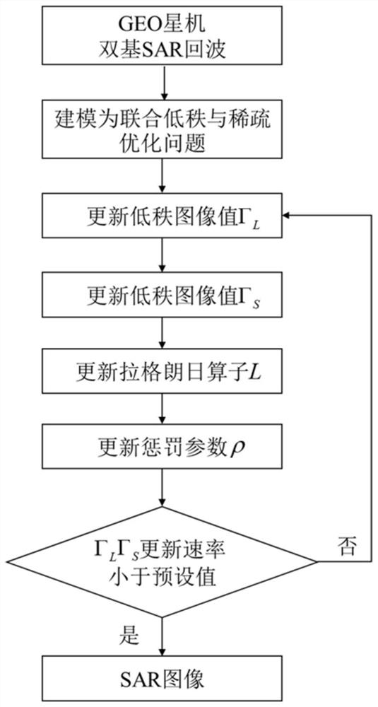
[0032] like figure 1 Shown is a flow chart of the method of the present invention, comprising the following steps:

[0033] Step S0: Establish the geometric relationship of the GEO satellite and dual-base SAR

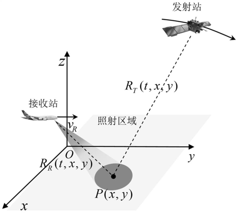
[0034] The observation geometry of GEO satellite bistatic SAR in the local coordinate system of the reference target is as follows figure 2 shown. The satellite provides beam coverage over the target area in high orbit, and the airborne receiver picks up the echoes in stripes. The coordinate center is denoted as O, the receiver flies parallel to the y-axis, and the flight speed is denoted as v R , the receiver position (x R ,y R ,z R ), x R , y R ,z R are the x, y, and z-axis coordinates of the...


PUM


Abstract

The invention discloses a GEO star-machine dual-base SAR non-fuzzy imaging processing method, which is applied in the field of radar technology, and aims at the problem that the existing technology cannot perform efficient and accurate imaging of the SAR echo signal under the GEO star-machine double-base SAR working mode , the present invention first completes the construction of the echo signal model according to the geometric relationship of the GEO satellite-machine bistatic SAR; then, establishes the echo decoupling observation model under-sampled in the azimuth; then, converts the decoupling observation model into a sparse and low-rank joint Solve the problem; finally, use the improved alternating direction multiplier method to restore the scene and obtain the imaging result; it can effectively solve the problem of low computational efficiency in the unambiguous imaging of the GEO satellite bistatic SAR, and can realize the high efficiency of the GEO satellite bistatic SAR. High-precision imaging.

Description

technical field [0001] The invention belongs to the technical field of radar, and particularly relates to a GEO (Geosynchronous Earth Orbits, geosynchronous orbit) star-machine dual-base SAR imaging technology. Background technique [0002] Synthetic Aperture Radar (SAR, Synthetic Aperture Radar) is an all-weather, all-weather high-resolution imaging system. It transmits a chirp signal with a large time-width product, and receives a pulse-compressed signal through matched filtering to obtain the range direction. High resolution, using synthetic aperture technology to achieve high resolution in azimuth. The imaging quality is not affected by weather conditions (clouds, light), etc., and has the characteristics of detecting and locating long-distance targets. Typical application fields of SAR include disaster monitoring, resource exploration, geological mapping, military reconnaissance, etc. [0003] Compared with the airborne bistatic SAR, the GEO satellite bistatic SAR pro...

Claims


Application Information

Patent Timeline
Patent Type & Authority Patents(China)
IPC IPC(8): G01S13/90G01S7/41G06F30/20
CPCG01S13/9058G01S13/9021G01S7/41G06F30/20
Inventor 安洪阳武俊杰王朝栋孙稚超李中余杨建宇
Owner UNIV OF ELECTRONICS SCI & TECH OF CHINA
Why Eureka
Try Eureka