CIM system working method based on BIM and GIS technologies

A working method and technology, applied in the computer field, can solve the problems of rough refined management, small concurrent data capacity, and inability to control engineering decision-making in management work, and achieve lower acquisition costs, extensive geographic information tagging, and comprehensive data statistics. Analyze and reduce the effect of real-time calculation

Pending Publication Date: 2021-08-17
苏州物图数字科技有限公司
View PDF0 Cites 1 Cited by
  • Summary
  • Abstract
  • Description
  • Claims
  • Application Information

AI Technical Summary

Problems solved by technology

At the same time, the GIS field still stays in the fields of map positioning and navigation due to its characteristics of being based on a lightweight environment and small concurrent data capacity. Simulation capability is relatively limited
[0003] Most of the existing CIM systems are based on the GIS system, which can only display various statistical data in multiple actual infrastructure projects on the display device in the form of map coordinates and related chart reports, lacking a high degree of simulation for a single infrastructure project Visual effects and fine-grained management, management work cannot go deep into specific projects for detailed business process decision-making control
However, BIM technology is mostly used in various 3D visualization applications of a single project from design to implementation to operation and maintenance stages, lacking the continuous management of large-scale overall infrastructure projects and the coherent implementation of technical standards

Method used


Image

  • CIM system working method based on BIM and GIS technologies
  • CIM system working method based on BIM and GIS technologies

Examples


Embodiment 1

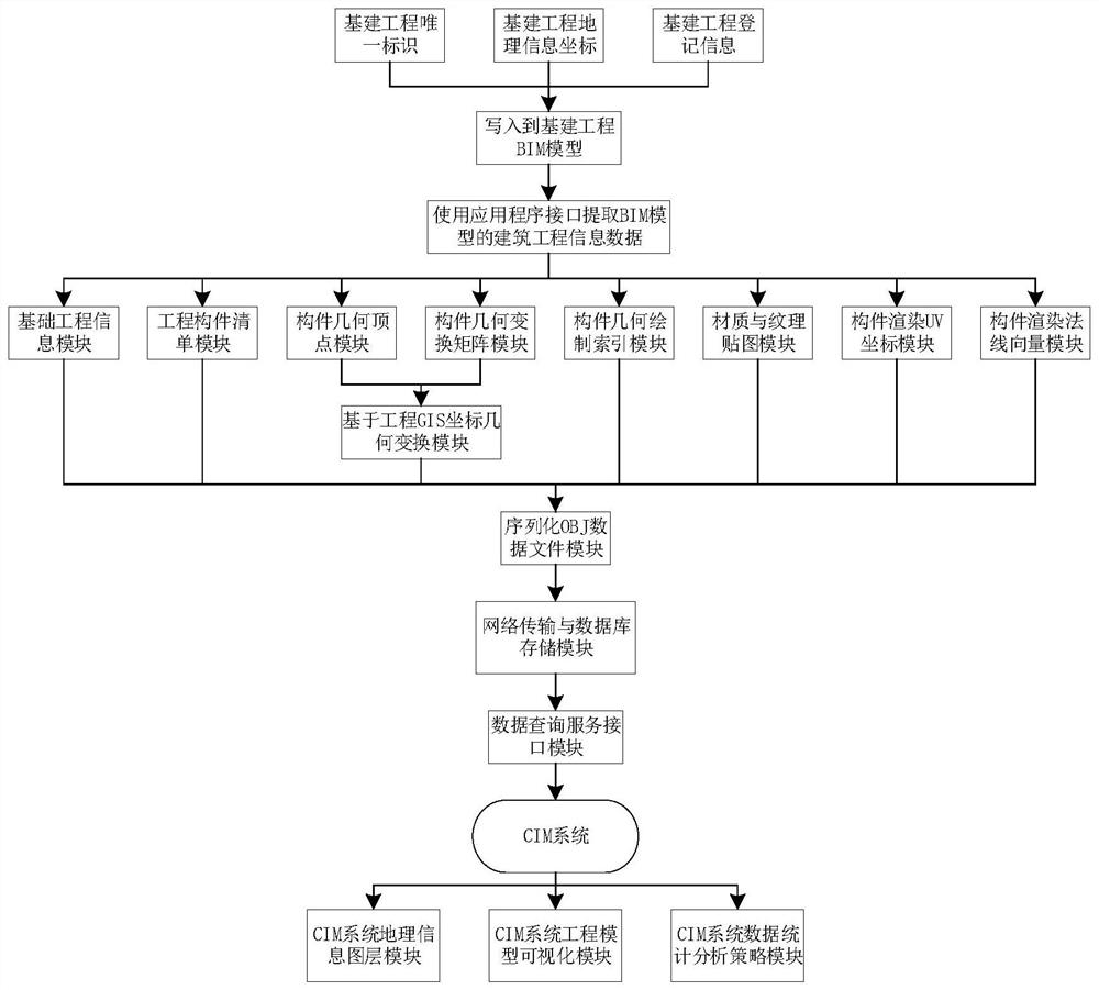
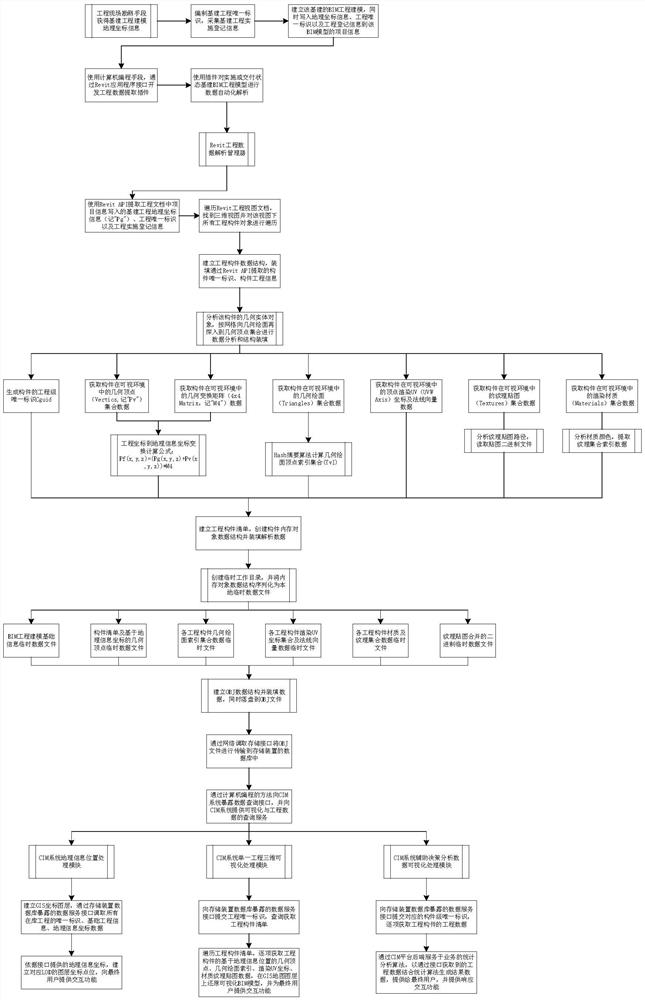
[0037] A working method of a CIM system based on BIM and GIS technology, the specific steps are as follows:

[0038] Step 1: Record the basic geographic information of the project through on-site survey, including longitude, latitude and elevation data. Plan the standards implemented by CIM, draw up the project code table, and establish the list of project groups at the same time, and assign unique identification information to individual planning projects. At the same time, the project construction registration information is collected and organized into a data structure in the form of key-value pairs.

[0039] Step 2: When modeling a BIM model (in Autodesk Revit software environment) for a single project, enter data including project geographic coordinate information (longitude, latitude and elevation data), project construction registration information, etc. in the project information of the BIM model.

[0040] Step 3: Through the application development interface provided...


PUM


Abstract

The invention discloses a method for implementing CIM (common information model) system development by combining BIM (building information modeling) and GIS (geographic information system) technologies. City-level standardized coding is applied in the design stage of a BIM model, data containing GIS information is coded into the BIM model, and model component set information is uploaded to various data storage interfaces on an online storage platform through a network in a data analysis mode when the BIM model is delivered. The information is stored in a database storage mode according to the unique identifier of the BIM model, GIS grid coordinates and other information in different regions and types, and meanwhile, a query service interface is provided for a GIS software system. The engineering data obtained by splitting is stored in a classified manner by using a database method, and can be provided for a third-party CIM system to carry out engineering visual presentation and data reutilization based on geographic position information, so that the technical barrier between the GIS and the BIM is broken through, and the technical threshold of the industry is reduced.

Description

technical field [0001] The invention relates to the field of computer technology, in particular to a method for realizing a CIM system based on BIM and GIS technologies. Background technique [0002] At present, CIM technology has been widely developed at home and abroad, but its technology implementation threshold is relatively high and the industry atmosphere is relatively single and closed. It is relatively difficult for CIM systems to achieve visualization and agile development. The basic implementation of the CIM system in the industry still stays in GIS and data statistical analysis and presentation. Moreover, the utilization of BIM models in the field of engineering visualization still stays in the software system of Autodesk, which has a large market share in the industry, and other sporadic software companies, and the learning environment is relatively closed, and the utilization method is relatively single. In recent years, the domestic infrastructure industry has...

Claims


Application Information

Patent Timeline
Patent Type & Authority Applications(China)
IPC IPC(8): G06F16/25G06F16/29G06F30/13G06T19/20
CPCG06T19/20G06F16/25G06F16/29G06F30/13
Inventor 张小琴
Owner 苏州物图数字科技有限公司
Why Eureka
Try Eureka