Variable plant protection super-dimensional pesticide application prescription map generation method
A prescription map, plant protection technology, applied in image enhancement, image data processing, data processing applications, etc., can solve problems such as excessive application of pesticides, and achieve the effect of reducing pesticide dosage, cost, and pesticide residues
- Summary
- Abstract
- Description
- Claims
- Application Information
AI Technical Summary
Problems solved by technology
Method used
Image
Examples
Embodiment 1
[0024] A method for generating a variable plant protection super-dimensional application prescription map provided by the present invention includes the following specific steps:
[0025] S1 to obtain spectral data: set a linear filter, the measured light from the measured object is irradiated on the linear filter, and the linear filter divides the measured light into multiple monochromatic lights arranged in parallel; and makes the linear The filter is imaged on the image sensor unit through the camera lens on the terminal to obtain the spectrum.
[0026] S2 Obtain field monitoring data: obtain field temperature and humidity, soil fertility, soil moisture meteorological data, etc.
[0027] S3 data preprocessing: Splice the collected aerial photography data, perform geometric correction after splicing, and perform radiation calibration, convert the DN value of the picture into reflectance, and finally save it as a TIFF file.
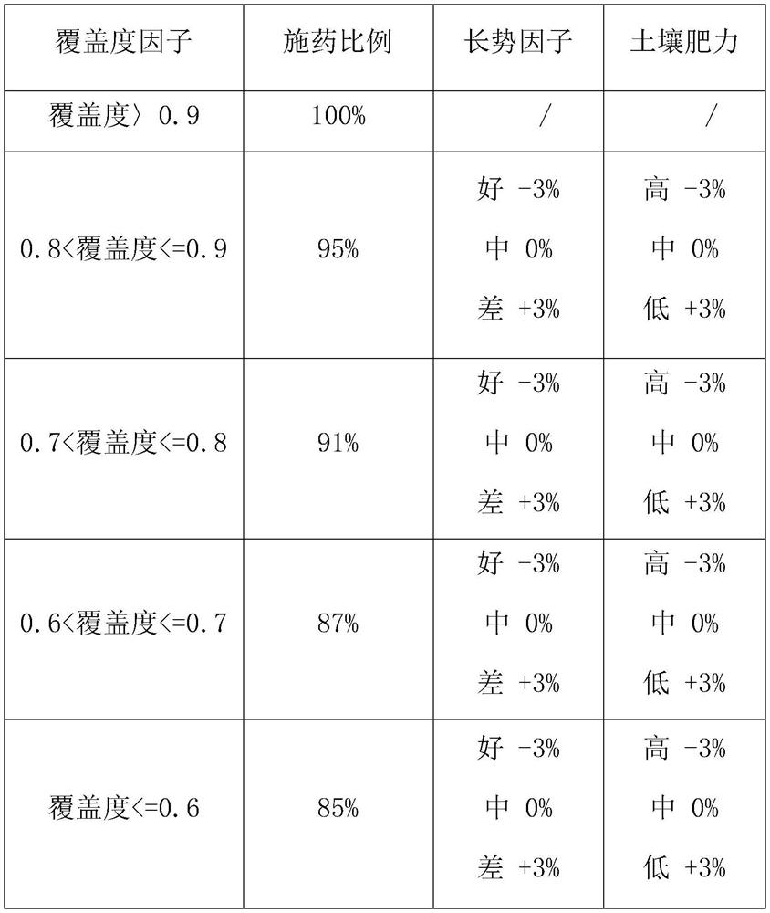
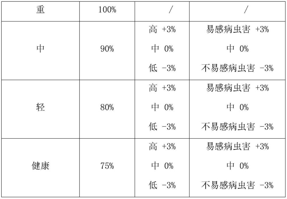
[0028] S4 Generate a preventive prescription map:...
Embodiment 2
[0034] A method for generating a variable plant protection super-dimensional application prescription map provided by the present invention includes the following specific steps:
[0035] S1 to obtain spectral data: set a linear filter, the measured light from the measured object is irradiated on the linear filter, and the linear filter divides the measured light into multiple monochromatic lights arranged in parallel; and makes the linear The filter is imaged on the image sensor unit through the camera lens on the terminal to obtain the spectrum.
[0036] S2 Obtain field monitoring data: obtain field temperature and humidity, soil fertility, soil moisture meteorological data, etc.
[0037] S3 data preprocessing: Splice the collected aerial photography data, perform geometric correction after splicing, and perform radiation calibration, convert the DN value of the picture into reflectance, and finally save it as a TIFF file.
[0038] S4 Generate a preventive prescription map:...
Embodiment 3
[0044] A method for generating a variable plant protection super-dimensional application prescription map provided by the present invention includes the following specific steps:
[0045]S1 to obtain spectral data: set a linear filter, the measured light from the measured object is irradiated on the linear filter, and the linear filter divides the measured light into multiple monochromatic lights arranged in parallel; and makes the linear The filter is imaged on the image sensor unit through the camera lens on the terminal to obtain the spectrum.
[0046] S2 Obtain field monitoring data: obtain field temperature and humidity, soil fertility, soil moisture meteorological data, etc.
[0047] S3 data preprocessing: Splice the collected aerial photography data, perform geometric correction after splicing, and perform radiation calibration, convert the DN value of the picture into reflectance, and finally save it as a TIFF file.
[0048] S4 Generate a preventive prescription map: ...
PUM
 Abstract
Description
Claims
Application Information
 - R&D
- Intellectual Property
- Life Sciences
- Materials
- Tech Scout
- Unparalleled Data Quality
- Higher Quality Content
- 60% Fewer Hallucinations
Browse by: Latest US Patents, China's latest patents, Technical Efficacy Thesaurus, Application Domain, Technology Topic, Popular Technical Reports.
© 2025 PatSnap. All rights reserved.Legal|Privacy policy|Modern Slavery Act Transparency Statement|Sitemap|About US| Contact US: help@patsnap.com


