ESDF map construction method based on light field imaging

A technology for map construction and light field imaging, which is applied in the field of image guidance and can solve the problems of large size, barrel distortion, and heavy weight of binocular cameras.

Pending Publication Date: 2021-08-24
NORTHWESTERN POLYTECHNICAL UNIV
View PDF0 Cites 0 Cited by
  • Summary
  • Abstract
  • Description
  • Claims
  • Application Information

AI Technical Summary

Problems solved by technology

[0003] Visual SLAM is divided into three types: monocular, binocular and RGB-D according to the sensor type. Because binocular cameras and RGB-D cameras can obtain the depth information of the scene, they are widely used in SLAM. However, due to the existing binocular The camera is large in size and heavy in weight, and the binocular camera will produce barrel-shaped distortion when acquiring images, making the subsequent image processing steps more cumbersome, so there are still problems in autonomous flights that require light weight and high speed. room for improvement

Method used


Image

  • ESDF map construction method based on light field imaging
  • ESDF map construction method based on light field imaging
  • ESDF map construction method based on light field imaging

Examples


Embodiment Construction

[0027] Now in conjunction with embodiment, accompanying drawing, the present invention will be further described:

[0028] To achieve the above object, the present invention adopts the following technical solutions to achieve:

[0029] A kind of ESDF map acquisition method design based on light field imaging, comprising the following steps:

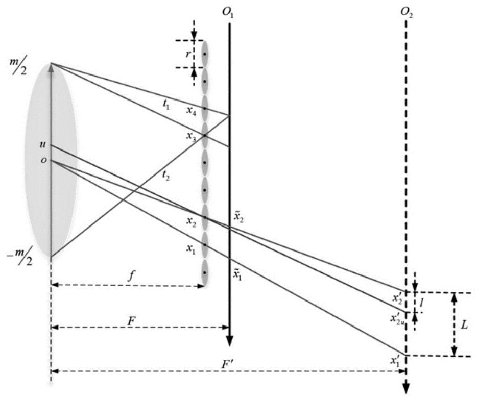
[0030] Step 1. Construct and calculate the expression of the refocusing coefficient α based on the structural refocusing model of the light field camera.

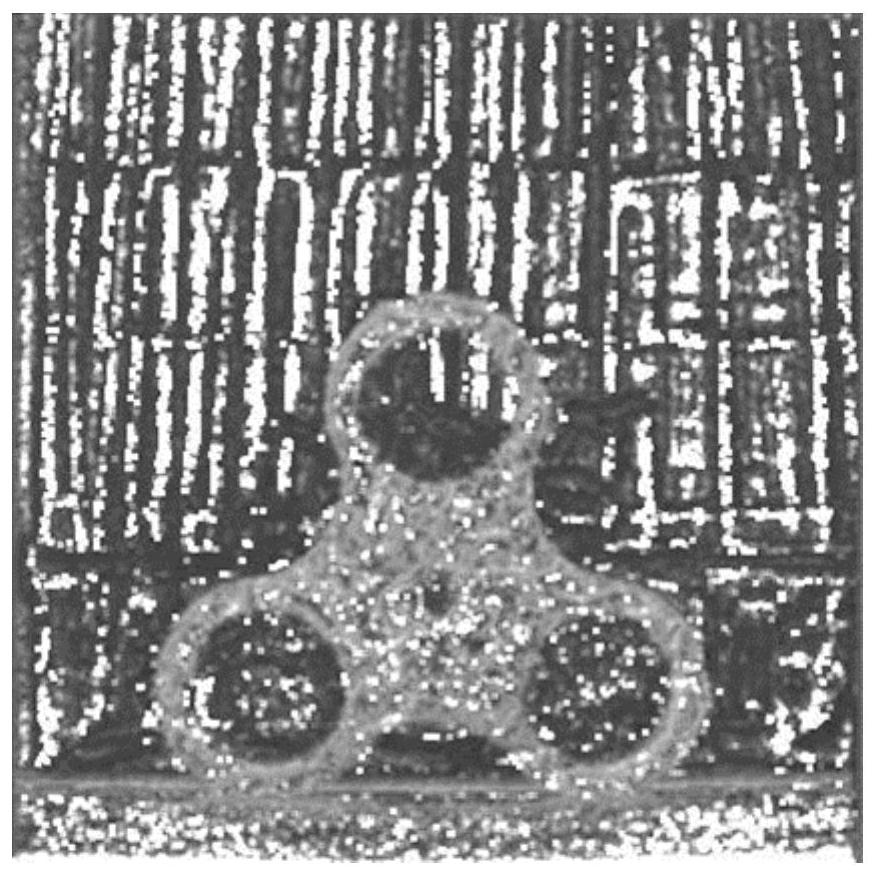
[0031] Step 2. Depth image preliminary extraction. Use the Canny operator to extract the edge of the image, calculate whether there is occlusion in the pixels on each edge, segment the area with the same angle area to achieve depth unity, and extract the preliminary depth image by traversing the refocusing coefficient.

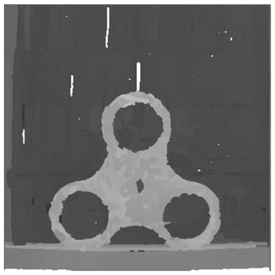
[0032] Step 3. Deep image optimization. Construct occluder clues according to the three evaluation indicators of gradient, variance, and mean, and optimize the edge...


PUM


Abstract

The invention relates to an ESDF map construction method based on light field imaging, the light field imaging is to simulate a binocular camera by adding a micro-lens array between a main lens and a sensor plane, and due to the existence of the micro-lens array, the spatial information and angle information of light are obtained at the same time; and the angle information is integrated to form depth information of each pixel point. And meanwhile, the pictures shot by the light field camera cannot cause barrel shape distortion. Therefore, the method has the advantages that the depth map can be generated according to light field imaging, the occupied space on the unmanned aerial vehicle is relatively low, barrel distortion cannot be generated and the like to replace application of a binocular camera in SLAM is replaced.

Description

technical field [0001] The invention belongs to image guidance and relates to an ESDF map construction method based on light field imaging. Background technique [0002] When the accuracy of the traditional navigation method is insufficient or fails, the visual navigation system with rich and accurate information, less interference and strong real-time performance is usually used as an auxiliary positioning method. It is the current mainstream technology to use the data of visual sensors to construct maps of unknown environments in real time to realize the autonomous navigation of UAVs in unfamiliar scenes. There are three common map forms: geometric maps, grid maps and point cloud maps. The point cloud map has the advantages of being able to reproduce the unknown environment as it is, and the generation method is simple, but because it contains so much information that the large amount of point cloud map data is not conducive to preservation, so grids are often used in real...

Claims


Application Information

Patent Timeline
IPC IPC(8): G06T17/05G06T7/13
CPCG06T17/05G06T7/13G06T2207/10012
Inventor 江奕蕾刘春江庞明慧闫斌斌张通
Owner NORTHWESTERN POLYTECHNICAL UNIV
Why Eureka
Try Eureka