Low-orbit navigation enhancement system
A system-enhancing and signal-enhancing technology, applied in the field of satellite navigation, can solve problems such as difficult to meet the high-precision application requirements of unmanned driving, and achieve the effect of accelerating the positioning convergence process, fast geometric movement, and enhancing service availability
- Summary
- Abstract
- Description
- Claims
- Application Information
AI Technical Summary
Problems solved by technology
Method used
Image
Examples
Embodiment 1
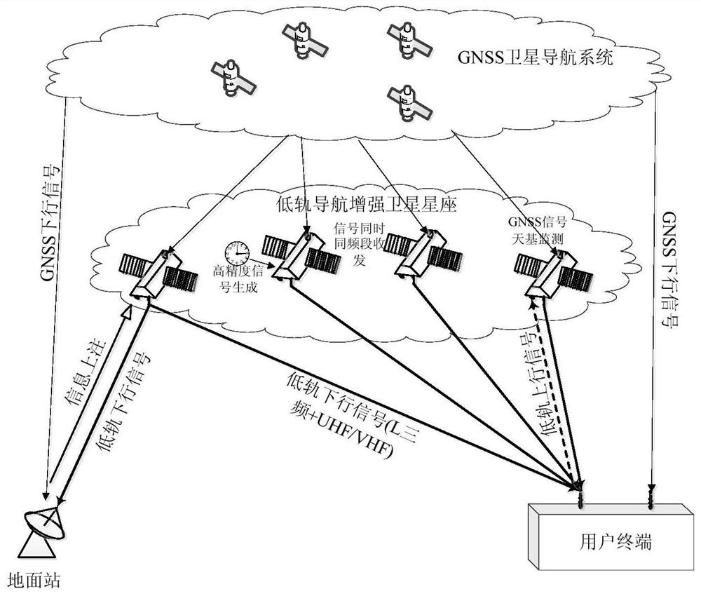
[0060] Such as figure 1 As shown, the present invention provides a low-orbit navigation enhancement system, which includes a low-orbit navigation enhancement satellite constellation. The low-orbit navigation enhancement satellite constellation is a low-orbit constellation composed of a plurality of low-orbit navigation enhancement satellites. Quadruple and above coverage, that is, the number of low-orbit satellites visible at any time on the ground is no less than four. The low-orbit navigation enhancement satellites have user downlinks and user uplinks, and the low-orbit navigation enhancement satellites It has an inter-satellite link; the visible low-orbit satellite refers to a visible low-orbit satellite with an elevation angle above 5°.
[0061] The low-orbit navigation enhancement satellite generates and broadcasts the first navigation enhancement signal, the first navigation enhancement signal carries the low-orbit navigation enhancement message, the low-orbit navigation...
Embodiment 2
[0115] The low-orbit satellite of the present invention generates and broadcasts a high-security signal with an authentication function, which has the characteristics of text authentication and spread-spectrum code authentication. The schematic diagram of the high-security signal structure is as follows Figure 5 shown.
[0116] The low-orbit navigation enhanced message is an encrypted message. Correspondingly, the navigation user terminal performs security authentication after receiving the low-orbit navigation enhanced message;
[0117] The process of encrypting the low-orbit navigation enhanced message by the low-orbit navigation satellite is as follows:
[0118] S2.1. Map the low-orbit navigation enhanced message to the first hash data hash1 with a fixed bit length through the HASH function, and then encrypt the first hash data hash1 with a private key to obtain a digital signature DS; standard non- Symmetric encryption technology, such as RSA encryption technology, encry...
Embodiment 3
[0129] In terms of service availability, the urban environment is the main application scenario of GNSS. However, high-rise buildings, viaducts, tree shade, etc. in the urban environment cause GNSS signal attenuation and even service interruption, which greatly affects service availability. Improving service availability in challenging environments is the direction of PNT services.
[0130] Preferably, the low-orbit navigation enhancement satellite also generates and broadcasts a second navigation enhancement signal, that is, the low-orbit navigation enhancement satellite generates and broadcasts an L-band triple-frequency navigation enhancement signal + UHF / VHF navigation enhancement signal. The second navigation enhancement signal is a spread-spectrum ranging signal, which is located in the UHF or VHF frequency band, and its landing power is higher than that of the GNSS signal, even 10dB higher than the GNSS signal, so that the user terminal can receive the second navigation ...
PUM
 Abstract
Description
Claims
Application Information
 - R&D
- Intellectual Property
- Life Sciences
- Materials
- Tech Scout
- Unparalleled Data Quality
- Higher Quality Content
- 60% Fewer Hallucinations
Browse by: Latest US Patents, China's latest patents, Technical Efficacy Thesaurus, Application Domain, Technology Topic, Popular Technical Reports.
© 2025 PatSnap. All rights reserved.Legal|Privacy policy|Modern Slavery Act Transparency Statement|Sitemap|About US| Contact US: help@patsnap.com


