Satellite remote sensing image farmland block segmentation method based on improved Mask R-CNN model
A remote sensing image and satellite remote sensing technology, which is applied in the field of remote sensing image processing, can solve problems such as feature redundancy, weight ratio, and important feature omission, and achieve improved instance segmentation effect, high robustness, and enhanced multi-scale The effect of feature fusion
- Summary
- Abstract
- Description
- Claims
- Application Information
AI Technical Summary
Problems solved by technology
Method used
Image
Examples
Embodiment 1
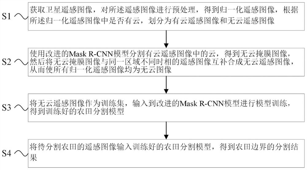
[0042] A farmland block segmentation method for satellite remote sensing images based on the improved Mask R-CNN model, such as figure 1 As shown, the method includes the following steps:
[0043] S1: Acquire satellite remote sensing images, preprocess the remote sensing images to obtain normalized remote sensing images, and divide them into cloudy remote sensing images and cloudless remote sensing images according to whether there are clouds in the normalized remote sensing images;
[0044] S2: Use the improved Mask R-CNN model to segment the cloud in the cloudy remote sensing image to obtain the cloudless mask image, and then combine the cloudless mask image with the remote sensing image of the same area in different phases to synthesize the cloudless remote sensing image, thus Make all normalized remote sensing images cloud-free;
[0045] S3: Take the cloud-free remote sensing image as the training set, input it into the improved Mask R-CNN model for model training, and ob...
Embodiment 2
[0049] The flow chart of the satellite remote sensing image farmland block segmentation method based on the improved Mask R-CNN model is as follows figure 1 shown, including the following steps:
[0050] S1: Acquire satellite remote sensing images, preprocess the remote sensing images to obtain normalized remote sensing images, and divide them into cloudy remote sensing images and cloudless remote sensing images according to whether there are clouds in the normalized remote sensing images;
[0051] Described pretreatment comprises:
[0052] S11: Acquiring RPC information of satellite remote sensing images;
[0053] S12: Respectively perform orthorectification on multispectral and panchromatic data of satellite remote sensing images based on RPC information;
[0054] S13: registering the multispectral data based on the panchromatic data;
[0055] S14: Perform an image fusion operation on the registered images;
[0056] S15: performing radiometric calibration and atmospheric...
Embodiment 3
[0069] The flow chart of the satellite remote sensing image farmland block segmentation method based on the improved Mask R-CNN model is as follows figure 1 shown, including the following steps:
[0070] S1: Acquire satellite remote sensing images, preprocess the remote sensing images to obtain normalized remote sensing images, and divide them into cloudy remote sensing images and cloudless remote sensing images according to whether there are clouds in the normalized remote sensing images;
[0071] Described pretreatment comprises:
[0072] S11: Acquiring RPC information of satellite remote sensing images;
[0073] S12: Respectively perform orthorectification on multispectral and panchromatic data of satellite remote sensing images based on RPC information;
[0074] S13: registering the multispectral data based on the panchromatic data;
[0075] S14: Perform an image fusion operation on the registered images;
[0076] S15: performing radiometric calibration and atmospheric...
PUM
 Abstract
Description
Claims
Application Information
 - R&D
- Intellectual Property
- Life Sciences
- Materials
- Tech Scout
- Unparalleled Data Quality
- Higher Quality Content
- 60% Fewer Hallucinations
Browse by: Latest US Patents, China's latest patents, Technical Efficacy Thesaurus, Application Domain, Technology Topic, Popular Technical Reports.
© 2025 PatSnap. All rights reserved.Legal|Privacy policy|Modern Slavery Act Transparency Statement|Sitemap|About US| Contact US: help@patsnap.com


