Remote sensing image scene multi-label classification method and device based on graph network, multi-label retrieval method and device

A remote sensing image, multi-label technology, applied in still image data retrieval, still image data clustering/classification, neural learning methods, etc. Information and other issues, to achieve the effect of good image features and accurate interpretation

Active Publication Date: 2022-04-26
NANJING UNIV OF INFORMATION SCI & TECH
View PDF7 Cites 0 Cited by
  • Summary
  • Abstract
  • Description
  • Claims
  • Application Information

AI Technical Summary

Problems solved by technology

[0005] The present invention aims at providing remote sensing image scene multi-label based on graph network for the existing single-label classification and retrieval method of remote sensing image scene, which ignores the multi-category feature information contained in the image and cannot meet the requirements of fine and accurate remote sensing image interpretation Classification method, multi-label classification device, multi-label retrieval method and multi-label retrieval device

Method used


Image

  • Remote sensing image scene multi-label classification method and device based on graph network, multi-label retrieval method and device
  • Remote sensing image scene multi-label classification method and device based on graph network, multi-label retrieval method and device
  • Remote sensing image scene multi-label classification method and device based on graph network, multi-label retrieval method and device

Examples


Embodiment 1

[0058] Embodiment 1: a remote sensing image scene multi-label classification method based on graph network, including:

[0059] Convert the image into a graph structure;

[0060] Using the pre-built and trained multi-scale graph convolution network, based on the graph structure, the multi-label classification is carried out on the ground objects in the image scene, and the multi-label classification results are obtained.

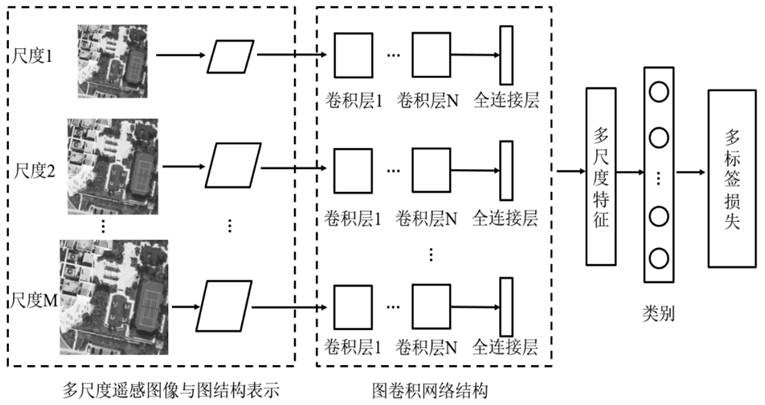
[0061] Building and training a multi-scale graph convolutional network includes:

[0062] Step 1. Construct a scene image library for multi-label classification and retrieval. During specific implementation, the scene image library may be constructed in advance. In the embodiment, firstly, large-scale remote sensing images are segmented with a fixed size to obtain a scene image library, and divided into training sets and the test set Two sub-image libraries, where the training set For network training, test set It is used for multi-label classifica...

Embodiment 2

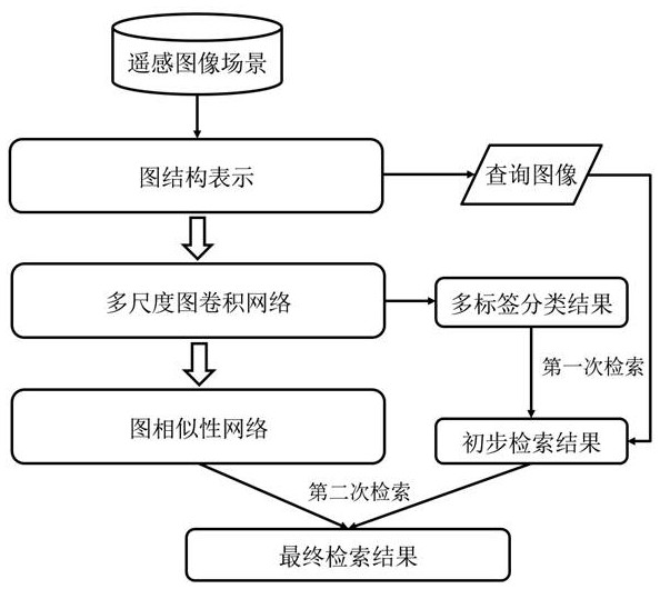
[0081] Embodiment 2: On the basis of Embodiment 1, this implementation provides a remote sensing image scene multi-label retrieval method based on a graph network (such as figure 1 shown), also includes:

[0082] Using the graph network-based remote sensing image scene multi-label classification method provided in the above embodiments to perform multi-label classification on the query image and the features in each image scene in the image database, and obtain the multi-label classification result;

[0083] Based on the graph structure converted from the query image and the result of multi-label classification, the image library is searched for the first time, and an image set containing at least one of the same features as the query image is obtained;

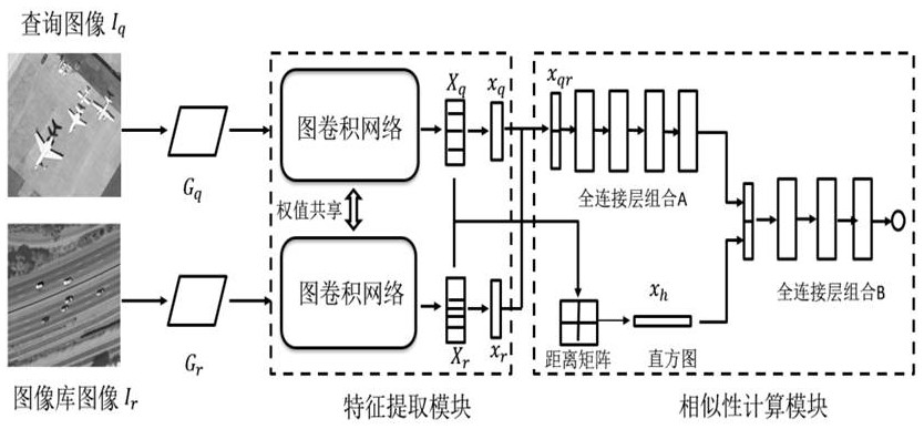
[0084] Using the pre-built and trained graph similarity network to search the image collection for the second time to obtain the similarity between the query image and other images in the image library, the graph similarity ...

Embodiment 3

[0100] Implementation 3: Corresponding to the graph network-based remote sensing image scene multi-label classification method provided in the above embodiment, this embodiment provides a graph network-based remote sensing image scene multi-label classification device, including a graph structure representation module and a multi-scale graph Convolutional network module;

[0101] The graph structure representation module is used to convert an image into a graph structure;

[0102] The multi-scale graph convolutional network module is used to construct and train the multi-scale graph convolutional network module; the pre-built and trained multi-scale graph convolutional network is used to perform multi-label classification on the ground objects in the image scene based on the graph structure , to obtain the multi-label classification result;

[0103] The multi-scale graph convolutional network module includes respectively established for different scales of the image N +1-lay...


PUM


Abstract

The invention discloses a remote sensing image scene multi-label classification method and device based on a graph network, a multi-label retrieval method and device, including converting the query image and each image in the image database into a graph structure; using a pre-built and trained multi-scale graph Convolutional network, based on the graph structure, performs multi-label classification on the ground objects in the image scene; based on the converted graph structure and multi-label classification results of the query image, the image library is searched for the first time, and the query image contains at least one of the same objects. The image collection of objects; use the pre-built and trained graph similarity network to perform a second search on the image collection to obtain the similarity between the query image and other images in the image database; return images according to the similarity to obtain the final multi-label retrieval result . The invention is beneficial for learning better image features and realizing more accurate interpretation of remote sensing images.

Description

technical field [0001] The invention belongs to the technical field of image processing, and relates to the technical field of a remote sensing image scene multi-label classification method based on a graph network, the technical field of a multi-label classification device, the technical field of a multi-label retrieval method, and the technical field of a multi-label retrieval device. Background technique [0002] With the continuous development of remote sensing earth observation technology, the spatial resolution of remote sensing images shows a trend of developing from medium and low resolution to high resolution. Different from low- and medium-resolution remote sensing images, high-resolution remote sensing images can provide more detailed information on ground objects due to their higher spatial resolution, providing a rich data source for remote sensing image understanding. For high-resolution remote sensing images, traditional pixel-level and object-level interpreta...

Claims


Application Information

Patent Timeline
Patent Type & Authority Patents(China)
IPC IPC(8): G06V10/764G06V10/774G06V10/776G06V10/26G06V10/74G06V10/82G06V20/10G06K9/62G06F16/55G06F16/583G06N3/04G06N3/08
CPCG06F16/55G06F16/583G06N3/08G06N3/048G06N3/045G06F18/217G06F18/2431G06F18/22G06F18/214
Inventor 周维勋耿万轩
Owner NANJING UNIV OF INFORMATION SCI & TECH
Why Eureka
Try Eureka