Supercharge Your Innovation With Domain-Expert AI Agents!

FKP calculation method for high-precision positioning CORS network in large height difference region

A high-precision, regional technology, applied in satellite radio beacon positioning systems, ICT adaptation, meteorology, etc., can solve the problems of low positioning accuracy, low positioning accuracy in areas with large altitude differences, and low positioning calculation accuracy, and achieve improved The effect of solving speed, solving stability is good, and speeding up the progress of solving

Pending Publication Date: 2022-02-08
WUHAN UNIV
View PDF1 Cites 0 Cited by
  • Summary
  • Abstract
  • Description
  • Claims
  • Application Information

AI Technical Summary

Problems solved by technology

[0004] Along the Sichuan-Tibet Railway, when using the existing network RTK for positioning, it often occurs that the network RTK user ambiguity cannot be fixed, or the positioning accuracy is too low. After further testing, it is found that the existing network RTK This problem is common in poor areas
[0005] When solving the problem of low positioning accuracy in areas with large elevation differences, an invention patent with the patent number CN202010892977.4 is proposed in the prior art, which discloses an RTK algorithm for correcting the tropospheric empirical model with measured meteorological parameters. The problem of low positioning accuracy under height difference, but this algorithm is only suitable for ordinary RTK, not for network RTK
[0006] At present, there is no method to solve the problem that network RTK cannot fix the ambiguity of network users in areas with large elevation differences, or the accuracy of positioning calculation is too low. Therefore, a CORS network calculation method in areas with large elevation differences is proposed to solve The network RTK ambiguity cannot be fixed in areas with large elevation differences, or the positioning accuracy is too low

Method used


Image

  • FKP calculation method for high-precision positioning CORS network in large height difference region

Examples


Embodiment 1

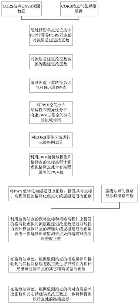
[0038] Implementation Example 1: Reference figure 1 , a high-precision positioning CORS network FKP solution method in a large elevation difference area, said method comprising:

[0039] Step 1: Obtain CORS station GNSS observation data and CORS station weather observation data;

[0040] Step 2: Calculate the total tropospheric delay correction number of each CORS site through the precise point positioning technology PPP;

[0041] Step 3: Calculate the wet delay correction number of each station from the solution of the tropospheric total delay correction number;

[0042] Step 4: Obtain the PWV value of each CORS site by the wet delay correction number of each CORS site;

[0043] Step 5: Use the coordinates, elevations, and PWV values ​​of each CORS station to conduct spatial structural analysis and spatial variability analysis to obtain a continuous, spatially correlated atmospheric precipitable water volume PWV random domain model within the coverage space of each CORS stati...


PUM


Abstract

The invention discloses an FKP calculation method for a high-precision positioning CORS network in a large height difference region. The method comprises the following steps: step 1, acquiring GNSS observation data and meteorological observation data of a CORS station; step 2, calculating a troposphere total delay correction number of each CORS station; step 3, calculating a wet delay correction number of each station; step 4, obtaining a PWV value of each CORS station; step 5, acquiring an atmospheric precipitable water PWV random domain model; step 6, performing three-dimensional grid subdivision on the three-dimensional space area covered by the CORS station; step 7, calculating a PWV value with an elevation attribute at the virtual grid point; step 8, broadcasting a grid virtual troposphere wet delay correction number; step 9, calculating an accurate troposphere error correction number at the monitoring station; step 10, calculating other accurate error corrections of the monitoring station; and step 11, calculating an accurate coordinate. The problem that in the prior art, network RTK user ambiguity cannot be fixed in a large height difference area, or positioning precision is too low is solved.

Description

technical field [0001] The invention relates to a high-precision positioning CORS network FKP solution method in a large elevation difference area, and belongs to the technical field of network RTK. Background technique [0002] The basic principle of network RTK (Real-time kinematic, real-time dynamic measurement technology) is to arrange multiple reference stations sparsely and evenly in a large area to form a network of reference stations, and calculate GNSS based on the data of these reference stations. (Global Navigation Satellite System, Global Navigation Satellite System) corrects the information and broadcasts it to users, thereby providing real-time centimeter-level positioning services for network RTK users in the area. [0003] Network RTK is composed of base station network, data processing center and data communication lines. The base station should be equipped with a dual-frequency full-wavelength GNSS receiver, which can simultaneously provide accurate dual-f...

Claims


Application Information

Patent Timeline
Patent Type & Authority Applications(China)
IPC IPC(8): G01W1/10G01S19/14
CPCG01W1/10G01S19/14Y02A90/10
Inventor 何林姚宜斌许超钤张良彭文杰孔建
Owner WUHAN UNIV
Features
  • R&D
  • Intellectual Property
  • Life Sciences
  • Materials
  • Tech Scout
  • Unparalleled Data Quality
  • Higher Quality Content
  • 60% Fewer Hallucinations
Learn More