
Underwater longitudinal and transverse section measurement method and system

A measurement method and cross-section technology, applied in the field of surveying and mapping, can solve problems such as low operation efficiency and low data accuracy, and achieve the effects of improving accuracy, realizing automatic output, and improving measurement operation efficiency

Pending Publication Date: 2022-02-25
GUANGZHOU SOUTH SATELLITE NAVIGATION INSTR
View PDF4 Cites 2 Cited by
  • Summary
  • Abstract
  • Description
  • Claims
  • Application Information

AI Technical Summary

Problems solved by technology

[0004] In order to overcome the defects of low data accuracy and low operating efficiency in underwater vertical and horizontal section measurement, the present invention provides an underwater vertical and horizontal section measurement method and an underwater vertical and horizontal section measurement system

Method used


Image

  • Underwater longitudinal and transverse section measurement method and system
  • Underwater longitudinal and transverse section measurement method and system
  • Underwater longitudinal and transverse section measurement method and system

Examples


Embodiment 1

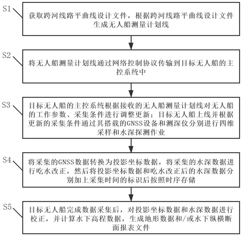
[0042] This embodiment proposes an underwater vertical and horizontal section measurement method, such as figure 1 Shown is a flow chart of the underwater longitudinal and cross-section measurement method of this embodiment.

[0043] In the underwater vertical and horizontal section measuring method that the present embodiment proposes, comprise the following steps:

[0044] S1. Obtain the horizontal curve design file of the river-crossing line, and generate the unmanned ship measurement plan line according to the horizontal curve design file of the river-crossing line.

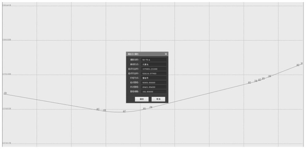
[0045] In this embodiment, the horizontal curve in the horizontal curve design document of the cross-river road is the road centerline, such as figure 2 As shown, it is a schematic diagram of the horizontal curve design file of the cross-river line in this embodiment. The unmanned ship will take the centerline of the road as the central axis to measure the vertical and horizontal sections.

[0046] The un...

Embodiment 2

[0078] This embodiment proposes an underwater vertical and horizontal section measurement system, which is applied to the underwater vertical and horizontal section measurement method proposed in Embodiment 1. Such as Figure 5 As shown, it is a structural diagram of the underwater longitudinal and cross-section measurement system of this embodiment.

[0079] The underwater longitudinal and cross-section measurement system proposed in this embodiment includes an unmanned ship, a design module, a communication module and a data processing module.

[0080] Wherein, the unmanned ship in this embodiment is equipped with a main control module, a GNSS positioning device and a depth sounder.

[0081] The design module is used to generate cross-river line level curve design files and unmanned ship survey planning lines.

[0082] In this embodiment, the design parameters in the horizontal curve design file of the cross-river road include road name, curve form, starting point north co...


PUM


Abstract

The invention relates to the technical field of surveying and mapping, and provides an underwater longitudinal and transverse section measurement method and system. The method comprises the following steps: obtaining a river-crossing line horizontal curve design file, and generating an unmanned ship measurement plan line; transmitting the unmanned ship measurement plan line to a main control module of the target unmanned ship; enabling the main control module of the target unmanned ship to adjust and update working parameters and acquisition conditions of the unmanned ship according to the received unmanned ship measurement plan line; enabling the target unmanned ship to carry out four-dimensional sampling and water depth detection operation through GNSS equipment and a depth finder carried by the target unmanned ship in an on-line parallel manner; performing coordinate transformation on the acquired GNSS data, performing draught correction on the acquired water depth data, adding an acquisition time identifier to the data, and storing the data according to a time sequence; and after the target unmanned ship completes data acquisition, correcting the projection coordinate data and the water depth data, calculating underwater elevation data, and generating topographic data and / or an underwater longitudinal and transverse section report file.

Description

technical field [0001] The invention relates to the technical field of surveying and mapping, and more specifically, to an underwater vertical and horizontal section measurement method and system. Background technique [0002] The relevant technologies based on RTK applied to land vertical and horizontal section surveying are very mature. For example, when measuring railway lines, it is necessary to measure the vertical and horizontal sections along the railway line. Land surveying generally adopts road surveying, importing the design files of horizontal curves and vertical curves into the hand book, and obtaining cross-section point data through actual surveying and mapping in the field. [0003] In the cross-river line, it is also necessary to survey and map the vertical and horizontal sections of the line. Underwater topographic surveying is the measurement of topography by using certain measuring instruments underwater, and the measurement is generally realized by deter...

Claims


Application Information

Patent Timeline
Patent Type & Authority Applications(China)
IPC IPC(8): G01C13/00G01C7/00
CPCG01C13/008G01C7/00Y02A90/30
Inventor 刘国光文述生王江林肖浩威丁永祥闫少霞郝志刚黄海锋
Owner GUANGZHOU SOUTH SATELLITE NAVIGATION INSTR
Learn More