Map superposition-based target exploration stratum exposure point navigation method and system

A navigation method and map technology, applied in the field of stratigraphic survey, can solve problems such as low efficiency in geological survey links, and achieve the effect of reducing the difficulty of finding and improving the efficiency

Pending Publication Date: 2022-03-18
CHINA PETROLEUM & CHEM CORP +1
View PDF0 Cites 0 Cited by
  • Summary
  • Abstract
  • Description
  • Claims
  • Application Information

AI Technical Summary

Problems solved by technology

[0006] The purpose of the present invention is to solve the problem of inefficiency in the geological survey link of oil and gas field exploration caused by the existing on-the-spot search method for the outcropping point of the target survey stratum

Method used


Image

  • Map superposition-based target exploration stratum exposure point navigation method and system
  • Map superposition-based target exploration stratum exposure point navigation method and system
  • Map superposition-based target exploration stratum exposure point navigation method and system

Examples


Embodiment 1

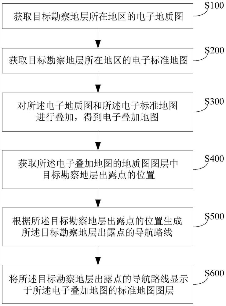
[0054] Example 1: figure 1 It shows the implementation flow chart of the method for navigating outcropping points of target survey formations based on map superposition in this embodiment. refer to figure 1 In this embodiment, the method for navigating outcropping points of target survey formations based on map superposition includes:

[0055] Step S100, obtaining the electronic geological map of the area where the target survey stratum is located;

[0056] Step S200, obtaining the electronic standard map of the area where the target survey stratum is located;

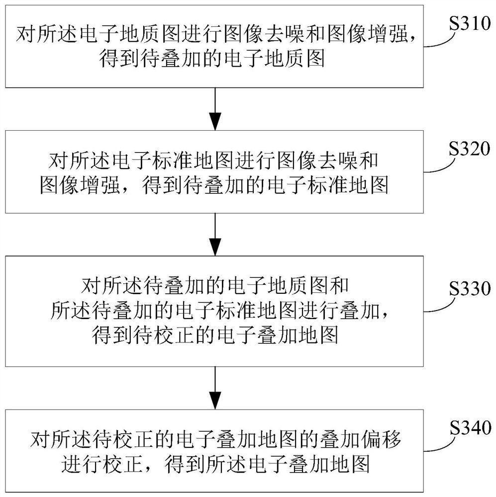
[0057] Step S300, superimposing the electronic geological map and the electronic standard map to obtain an electronic superimposed map;

[0058] Step S400, obtaining the position of the outcropping point of the target survey formation in the geological map layer of the electronic overlay map;

[0059] Step S500, generating a navigation route for the outcropping point of the target surveying stratum according to the...

Embodiment 2

[0078] Example 2: figure 1 It shows the implementation flow chart of the method for navigating outcropping points of target survey formations based on map superposition in this embodiment. refer to figure 1 In this embodiment, the method for navigating outcropping points of target survey formations based on map superposition includes:

[0079] Step S100, obtaining the electronic geological map of the area where the target survey stratum is located;

[0080] Step S200, obtaining the electronic standard map of the area where the target survey stratum is located;

[0081] Step S300, superimposing the electronic geological map and the electronic standard map to obtain an electronic superimposed map;

[0082] Step S400, obtaining the position of the outcropping point of the target survey formation in the geological map layer of the electronic overlay map;

[0083] Step S500, generating a navigation route for the outcropping point of the target surveying stratum according to the...

Embodiment 3

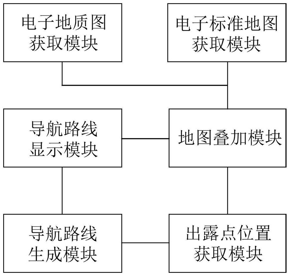
[0097] Example 3: image 3 A structural block diagram of the outcropping point navigation system for target exploration strata based on map superposition in this embodiment is shown. refer to image 3 In this embodiment, the navigation system for outcropping points of target survey strata based on map superposition includes:

[0098] The electronic geological map acquisition module is used to obtain the electronic geological map of the area where the target survey stratum is located;

[0099] The electronic standard map acquisition module is used to obtain the electronic standard map of the area where the target survey stratum is located;

[0100] A map overlay module, configured to overlay the electronic geological map and the electronic standard map to obtain an electronic overlay map;

[0101] The exposure point position acquisition module is used to obtain the position of the exposure point of the target survey formation in the geological map layer of the electronic ove...


PUM


Abstract

The invention discloses a map superposition-based target exploration stratum exposure point navigation method and a map superposition-based target exploration stratum exposure point navigation system. The method comprises the following steps: acquiring an electronic geological map of a region where a target exploration stratum is located; acquiring an electronic standard map of a region where the target exploration stratum is located; superposing the electronic geological map and the electronic standard map to obtain an electronic superposed map; obtaining the position of a dew point of a target exploration stratum in the geological map layer of the electronic overlay map; generating a navigation route of the exposure point of the target exploration stratum according to the position of the exposure point of the target exploration stratum; and displaying the navigation route of the exposure point of the target exploration stratum on a standard map layer of the electronic overlay map. The system provided by the invention comprises functional modules for correspondingly realizing the steps of each method. According to the invention, the problem of low efficiency of the geological exploration link of oil and gas field exploration caused by the existing on-site searching method of the exposure point of the target exploration stratum can be effectively solved.

Description

technical field [0001] The invention belongs to the technical field of stratum surveying, and more particularly relates to a method and system for navigating outcropping points of strata for target surveying based on map superposition. Background technique [0002] The exploration and development process of oil and gas fields mainly includes geological survey, geophysical prospecting, drilling, mud logging, logging, cementing, well completion, perforation, oil production, well workover, incremental production, transportation and processing, etc. These links are closely linked One ring, interdependent and inseparable. [0003] Among them, geological exploration is that petroleum prospectors use geological knowledge and carry simple tools such as compass and hammer to directly observe and study the bottom layer and rocks exposed on the ground in the field, understand the sedimentary strata and structural characteristics, and collect all geological data for Find out the favora...

Claims


Application Information

Patent Timeline
IPC IPC(8): G01C21/20
CPCG01C21/20
Inventor 韩月卿李双建张荣强沃玉进郝运轻袁玉松林娟华张军涛张涛李英强
Owner CHINA PETROLEUM & CHEM CORP
Why Eureka
Try Eureka