Unmanned aerial vehicle ground target positioning method based on different-source image matching

A technology of heterogeneous images and ground targets, which is applied in the field of UAV ground target positioning based on heterogeneous image matching, can solve the problems of affecting the accuracy of target positioning and the inability to obtain its own accurate position, and achieve strong anti-electromagnetic interference ability and implementation Convenience and easy operation

Pending Publication Date: 2022-03-25
湖北航天飞行器研究所
View PDF0 Cites 5 Cited by
  • Summary
  • Abstract
  • Description
  • Claims
  • Application Information

AI Technical Summary

Problems solved by technology

[0003] Aiming at the problem that the existing UAV ground target positioning method cannot obtain its own accurate position without GPS signal, thereby affecting the target positioning accuracy, the present invention proposes a UAV ground target positioning method based on heterogeneous image matching, This method does not rely on GPS and can complete ground target positioning without the UAV's own position information

Method used


Image

  • Unmanned aerial vehicle ground target positioning method based on different-source image matching
  • Unmanned aerial vehicle ground target positioning method based on different-source image matching
  • Unmanned aerial vehicle ground target positioning method based on different-source image matching

Examples


Embodiment Construction

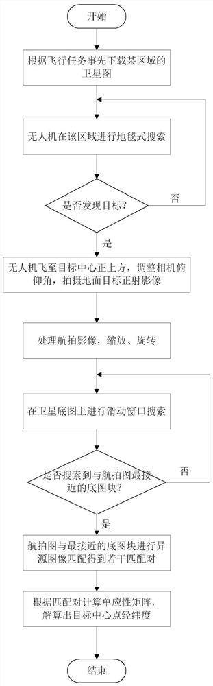
[0040] In order to make the object, technical solution and advantages of the present invention more clear, the present invention will be further described in detail below in conjunction with the accompanying drawings and embodiments. It should be understood that the specific embodiments described here are only used to explain the present invention, and are not intended to limit the present invention. In addition, the technical features involved in the embodiments of the present invention described below may be combined with each other as long as they do not conflict with each other.

[0041] Such as figure 1 As shown, the present invention provides a UAV ground target positioning method based on heterogeneous image matching, comprising the following steps:

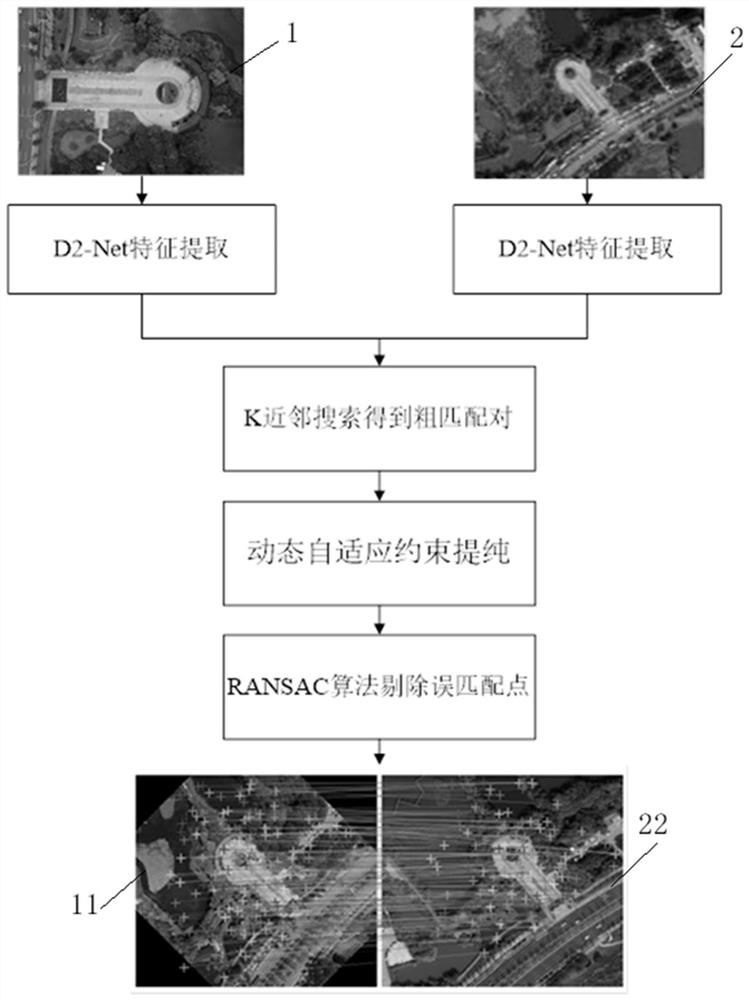
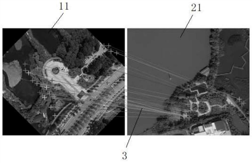
[0042] S1. According to the flight mission of the UAV, obtain the high-resolution remote sensing satellite image of its flight area from the Internet. Each pixel on the satellite image has accurate latitude and longitude...


PUM


Abstract

The invention relates to an unmanned aerial vehicle ground target positioning method based on different-source image matching, and the method comprises the following steps: S1, obtaining a high-resolution remote sensing satellite map of a flight region of an unmanned aerial vehicle from the Internet according to a flight task of the unmanned aerial vehicle; s2, the unmanned aerial vehicle carries a visible light camera, carpet type search is carried out in the flight area, the pitch angle of the camera is adjusted so that the camera can keep ortho-shooting on the target, and an ortho-image of the target is shot; s3, processing the aerial image; s4, performing sliding window search on the satellite base map to obtain a plurality of base map blocks, and searching a base map block closest to the aerial photo in all the base map blocks; and S5, according to a matching pair obtained by carrying out heterogeneous image matching on the aerial image and the closest base image block, calculating a homography matrix M of the two images by utilizing OpenCV, mapping the central point of the aerial image to the satellite base image by M, and obtaining the central point of the aerial image, namely the longitude and latitude of the center of the target. The method provided by the invention is stronger in anti-interference capability, can better adapt to a field environment, and can carry out unmanned aerial vehicle ground target positioning without depending on a GPS (Global Positioning System).

Description

technical field [0001] The invention belongs to the field of ground target positioning, and more particularly relates to a ground target positioning method for an unmanned aerial vehicle based on heterogeneous image matching. Background technique [0002] Unmanned aerial vehicle (UAV) has unique advantages and flexibility, and undertakes various application scenarios such as battlefield, rescue reconnaissance and target surveillance and other tasks. The positioning function of the UAV to the ground target is the premise of realizing these tasks. The existing positioning technology mainly relies on the photoelectric reconnaissance platform. The photoelectric platform needs to be equipped with a laser rangefinder. Through the photoelectric reconnaissance platform, information such as the azimuth and distance of the target relative to the photoelectric platform can be obtained, and then combined with the position of the UAV itself And attitude information, through the target p...

Claims


Application Information

Patent Timeline
Patent Type & Authority Applications(China)
IPC IPC(8): G06F16/532G06F16/58G06F16/583G06F16/587G06K9/62G06V10/75
CPCG06F16/532G06F16/5866G06F16/587G06F16/583
Inventor 兰子柠张华君李钟谷陈文鑫张紫龙周子鸣
Owner 湖北航天飞行器研究所
Why Eureka
Try Eureka