Hill plot depth segmentation and extraction method based on improved Unit + + network model

A deep segmentation and network model technology, applied in biological neural network models, neural learning methods, image analysis, etc., can solve problems such as complex terrain conditions, salt and pepper phenomenon, and heavy workload, and achieve smoothness and integrity. The effect of popularizing applications and improving classification accuracy

Pending Publication Date: 2022-03-29
INST OF AGRI RESOURCES & REGIONAL PLANNING CHINESE ACADEMY OF AGRI SCI +2
View PDF4 Cites 2 Cited by
  • Summary
  • Abstract
  • Description
  • Claims
  • Application Information

AI Technical Summary

Problems solved by technology

However, traditional remote sensing information extraction, including maximum likelihood, support vector machine, random forest, etc., is based on pixel classification, which will cause salt and pepper phenomenon, and the integrity of the plot, boundary information and its extraction accuracy are all low
Although the visual interpretation method can obtain high accuracy of plot information, it requires a lot of manpower and material resources, and the information acquisition cycle is long, which is difficult to meet the real-time and refined requirements of land monitoring and crop damage assessment.
In existing studies, the extraction of cultivated land information has achieved good classification results in densely planted and single plain areas. However, the characteristics of cultivated land in my country are complex and diverse, especially in hilly areas. The shape and size of the borders of the plots are different, and the terrain conditions are complex, which makes it difficult to quickly and accurately obtain mountain cultivated land information, and it is difficult to quickly and automatically extract mountain cultivated land information based on traditional remote sensing monitoring methods, which hinders the accurate extraction of remote sensing cultivated land information. brought great challenges
At the same time, due to the shadows formed on the image by the terrain undulations in the hilly area, the spectral characteristics of the sloping farmland are very complicated. In the image, the sloping farmland presents different tones
If conventional supervised classification is used to manually select training samples of sloping farmland, the workload is heavy, and it is difficult to accurately obtain samples of sloping farmland, which will affect the classification accuracy
Although the object-oriented classification method makes full use of the relevant features of image objects to complete the multi-scale segmentation of images, which can effectively reduce the salt and pepper phenomenon in the classification process and improve the classification accuracy of ground objects, but the different resolution images and planting conditions are different. It is often difficult to accurately determine the image segmentation scale, and it is often difficult to obtain better segmentation results in areas with high fragmentation

Method used


Image

  • Hill plot depth segmentation and extraction method based on improved Unit + + network model
  • Hill plot depth segmentation and extraction method based on improved Unit + + network model
  • Hill plot depth segmentation and extraction method based on improved Unit + + network model

Examples


Embodiment Construction

[0035] The present invention will be described in detail below in conjunction with specific embodiments.

[0036] Step 1: Acquire the Gaofen-1 (GF-1) remote sensing image data of Qingshuihe County and Yangyuan County. Using the L1A-level Gaofen-1 image, the Gaofen-1 image data for 2019 and 2021 were downloaded from the website of the Land Observation Satellite Center. And use Radiometric Calibration, FLAASH Atmospheric Correction, RPCOrthorectification Workflow and NNDiffuse Pan Sharpening modules in ENVI to perform preprocessing operations such as radiometric calibration, atmospheric correction, orthorectification, image fusion, and cropping.

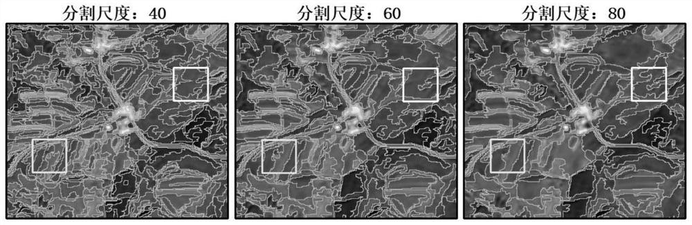
[0037] Step 2: Combining field investigation and visual interpretation, use the multi-scale segmentation method in image segmentation to make data sets with different segmentation scales, and make 40, 60, and 80 segmentation scales respectively, such as figure 1 shown.

[0038] Step 3: When the segmentation scale is 60, the integrity...


PUM


Abstract

The invention discloses a hilly land parcel depth segmentation and extraction method based on an improved Unit + + network model. The method comprises the following steps: step 1, acquiring remote sensing image data of GF-1 in a research area and performing preprocessing; 2, in combination with field investigation and visual interpretation, making data sets with different segmentation scales by using a multi-scale segmentation method in image segmentation; 3, comparing the optimal segmentation scale, and correcting the optimal segmentation scale again to enable the optimal segmentation scale to meet the precision requirement of the training set; 4, cutting the corrected training set image by adopting a regular grid; 5, filling the data through data enhancement operation, and dividing the image into a training set and a verification set according to a ratio of 4: 1; step 6, performing modeling by using a Unit + + network based on a cosine annealing learning rate; according to the method, the principle of establishing the Unet + + network model based on the cosine annealing learning rate is simple, operation is convenient, and the method has high flexibility, practicability and universality at the same time.

Description

technical field [0001] The invention belongs to the technical field of depth segmentation and extraction methods of hilly land, in particular to a method for deep segmentation and extraction of hilly land based on the Unet++ network model of cosine annealing learning rate. Background technique [0002] Cultivated land is an indispensable resource for human survival and development. Real-time and dynamic monitoring of cultivated land information is the basic data for crop area monitoring, growth monitoring and yield forecasting. With the rapid development and rapid acquisition of satellite and high-resolution images, it is possible to monitor cultivated land information on a large scale, accurately and effectively. In the 1970s, experts and scholars in European and American countries have begun to study the use of remote sensing data to extract cultivated land information. However, traditional remote sensing information extraction, including maximum likelihood, support vecto...

Claims


Application Information

Patent Timeline
Patent Type & Authority Applications(China)
IPC IPC(8): G06T7/11G06K9/62G06V10/774G06V10/764G06V10/82G06N3/04G06N3/08
CPCG06T7/11G06N3/08G06T2207/10032G06T2207/20081G06T2207/20084G06T2207/20192G06T2207/30188G06N3/045G06F18/241G06F18/214
Inventor 高懋芳张海天王天丽任超张蕙杰
Owner INST OF AGRI RESOURCES & REGIONAL PLANNING CHINESE ACADEMY OF AGRI SCI
Why Eureka
Try Eureka