Method and system for fast point cloud data processing and target image matching

A point cloud data and target image technology, applied in character and pattern recognition, instruments, computer components, etc., can solve the problems of inability to obtain color information and low image resolution, and achieve the effect of improving overall performance and ensuring accuracy

Pending Publication Date: 2022-04-08
UNIV OF ELECTRONICS SCI & TECH OF CHINA
View PDF9 Cites 4 Cited by
  • Summary
  • Abstract
  • Description
  • Claims
  • Application Information

AI Technical Summary

Problems solved by technology

[0005] In view of the problems of the above research, the purpose of the present invention is to provide a method and system for fast point cloud data processing and target image matching, which solves the problem that the image resolution of the laser radar in the prior art is low and the color of the object cannot be obtained. information problem

Method used


Image

  • Method and system for fast point cloud data processing and target image matching
  • Method and system for fast point cloud data processing and target image matching
  • Method and system for fast point cloud data processing and target image matching

Examples


Embodiment

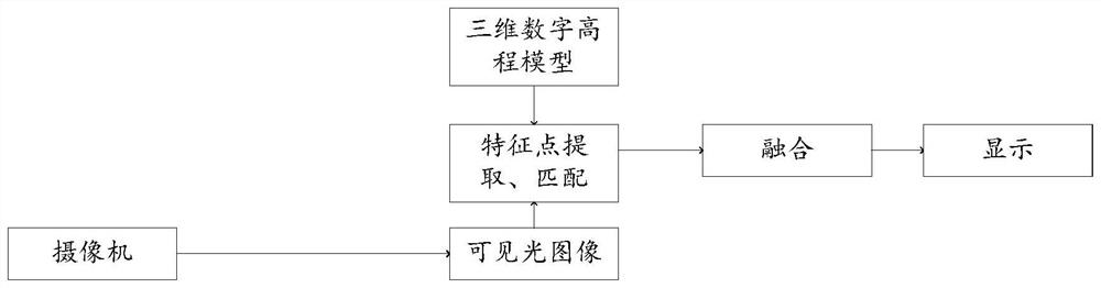
[0106] The present invention provides a method for fast point cloud data processing and target image matching, which processes the point cloud data in the Wushan County area and combines it with the visible light color image formed by the optical system (that is, the visible light image mentioned above) Match Fusion. For point cloud data, the digital elevation model is represented by regular squares or rectangles, each grid cell represents a value, which is represented by a matrix in mathematics, and represented by an array on the computer, and each array corresponds to an elevation value . The regular grid divides the spatial area into regularly spaced square grids or longitude and latitude arrays, and each row and column number represents the spatial relationship between adjacent grid points.

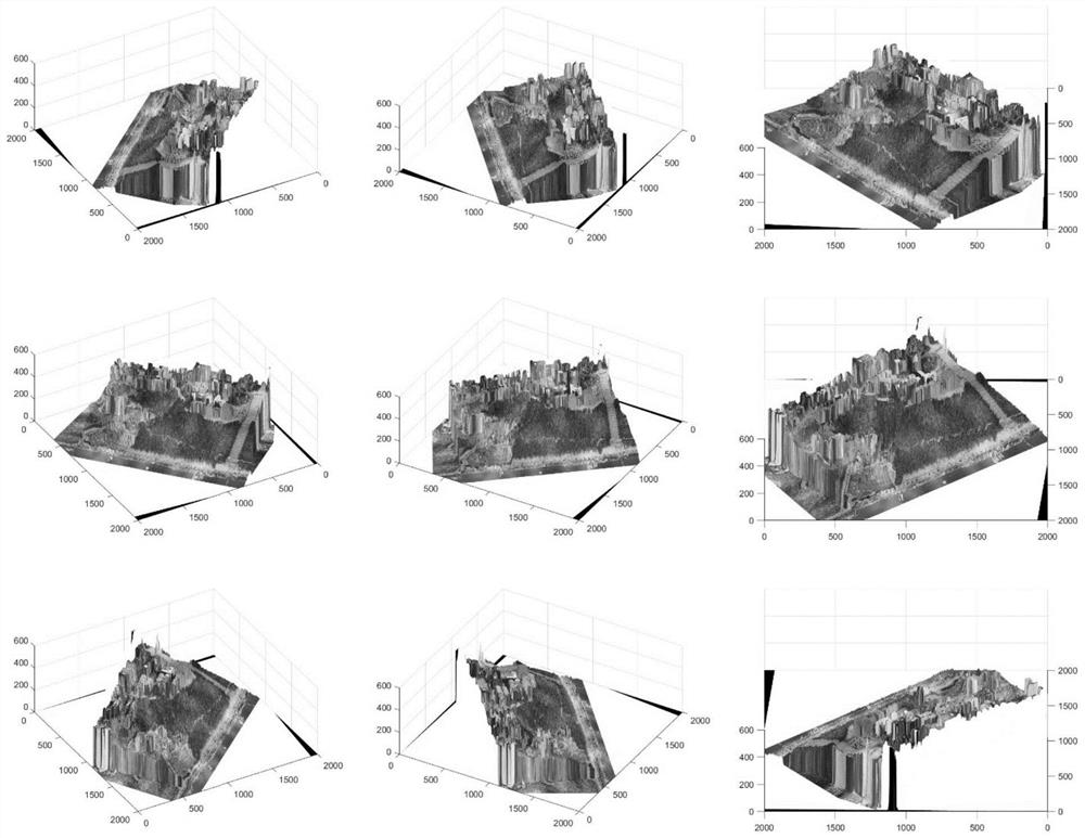
[0107] In the original point cloud data, the distance in the x direction is 631 meters, the y direction is 571 meters, and the z direction is 296 meters. 2000*2000 grid points selec...


PUM


Abstract

The invention provides a rapid point cloud data processing and target image matching method and system, belongs to the technical field of software algorithms, and solves the problems that in the prior art, an image formed by a laser radar is low in resolution, and color information of an object cannot be obtained. The method comprises the following steps: removing solar background noise points in point cloud data; after denoising, classifying ground points and non-ground points; according to the classified point cloud data, dividing a spatial region into square grids or longitude and latitude arrays at regular intervals by using regular grids to establish a digital elevation model; performing smooth de-noising processing on the digital elevation model to obtain a de-noised three-dimensional digital elevation model; and correspondingly assigning the color information in the two-dimensional visible light image to the three-dimensional digital elevation model based on the extracted feature points of the denoised three-dimensional digital elevation model and the feature points of the two-dimensional visible light image in the corresponding area to obtain a final target image. The method is used for fusion of the point cloud data and the visible light image.

Description

technical field [0001] A method and system for fast point cloud data processing and target image matching are used for the fusion of point cloud data and visible light images, and belong to the technical field of software algorithms. Background technique [0002] 3D imaging lidar generally adopts a linear detection system, and uses a laser rangefinder to fuse distance information and azimuth coordinates to generate target 3D point cloud data with detailed distance information. Space-borne 3D lidar imaging radar is a typical application of lidar systems, which can acquire high-precision 3D terrain data in a large area and a wide area within a limited time, and laser pulses can partially penetrate vegetation occlusion, so as to obtain ground elevation and reconstruct The three-dimensional topography of the surface can even be reversed to show the evolution of surface vegetation, which has great advantages over traditional surveying and mapping. However, in the fields of high-...

Claims


Application Information

Patent Timeline
Patent Type & Authority Applications(China)
IPC IPC(8): G06V10/75G06V10/30G06V10/46G06K9/62
Inventor 余剑桥吕海峰梁琨柯莎莎
Owner UNIV OF ELECTRONICS SCI & TECH OF CHINA
Why Eureka
Try Eureka