Airport scene route planning processing method based on grid 5D data model

An airport scene and data model technology, applied in image data processing, 3D modeling, geometric CAD, etc., can solve problems such as error-prone, time-consuming, and incomplete data, and achieve data refinement, improve safety, and improve accuracy. Effect

Pending Publication Date: 2022-04-26
NANJING LES INFORMATION TECH
View PDF0 Cites 1 Cited by
  • Summary
  • Abstract
  • Description
  • Claims
  • Application Information

AI Technical Summary

Problems solved by technology

[0004] Aiming at the deficiencies of the above-mentioned prior art, the purpose of the present invention is to provide a method for processing airport surface routing planning based on a grid 5D data model, so as to solve the problem of importing airport surface basic data based on manual extraction of airport CAD maps in the prior art. In the airport surface control system, the basic data of the airport is not fine and accurate, the data is not structured and unified, the data is not perfect, and the purely manual production and setting is time-consuming and error-prone. Good or wrong problems, improve the accuracy, rationality, and usability of routing planning

Method used


Image

  • Airport scene route planning processing method based on grid 5D data model
  • Airport scene route planning processing method based on grid 5D data model
  • Airport scene route planning processing method based on grid 5D data model

Examples


Embodiment Construction

[0040] In order to facilitate the understanding of those skilled in the art, the present invention will be further described below in conjunction with the embodiments and accompanying drawings, and the contents mentioned in the embodiments are not intended to limit the present invention.

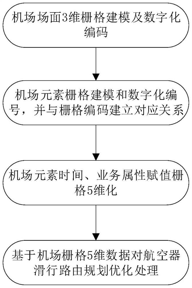
[0041] refer to figure 1 Shown, a kind of airport surface routing planning processing method based on grid 5D data model of the present invention, the steps are as follows:

[0042] 1) Use the 3D global latitude and longitude subdivision grid (GeoSOT-3D) method to carry out grid modeling and digital coding of the airport scene;

[0043]Wherein, the step 1) specifically includes: dividing the airport scene into gapless grid models contained in different scales and levels, constructing the airport scene grid model, and encoding the grids of each level to form a code and a grid. A mapped grid network system framework forms a new description method of airport scene organization; at this time, e...


PUM


Abstract

The invention discloses an airport scene route planning processing method based on a grid 5D data model. The method comprises the following steps: carrying out grid modeling and digital coding on an airport scene by adopting a three-dimensional global latitude and longitude grid subdivision method; performing grid modeling and digital numbering on the airport elements, and establishing a mapping corresponding relation with grid codes; time and service attribute marking assignment is carried out by taking airport elements as units, and then airport element grid attributes are extended from three dimensions to five dimensions; and carrying out optimization processing on aircraft taxiing route planning based on airport grid five-dimensional data. According to the method, refinement, structuralization, accuracy and completeness of airport scene data and automation of partial data setting are realized, better and more reasonable aircraft taxiing planning path reference information is provided, and scene operation safety and efficiency are improved.

Description

technical field [0001] The invention belongs to the technical field of airport surface control, and specifically refers to an airport surface routing planning processing method based on a grid 5D data model. Background technique [0002] In large and medium-sized airports, in order to ensure the safe, efficient and orderly operation of aircraft and vehicles on the airport surface, tower controllers need advanced surface guidance and control system (A-SMGCS), tower control automation system and other airport surface control systems to provide accurate and available aircraft Taxi route planning and other information help it conduct safe and efficient command and dispatch. The accuracy and usability of airport surface routing planning processing largely depend on the completeness, accuracy, refinement, and structure of the basic airport surface data. [0003] However, at present, the basic data of the airport scene is manually extracted based on the airport CAD map and importe...

Claims


Application Information

Patent Timeline
Patent Type & Authority Applications(China)
IPC IPC(8): G06F30/13G06F30/20G06T17/05
CPCG06F30/13G06F30/20G06T17/05
Inventor 王振飞丁一波邬秋香黄琰左莉程先峰靳学梅何亮席杨
Owner NANJING LES INFORMATION TECH
Why Eureka
Try Eureka