Large-scale water conservancy project management method and system based on GIS and BIM

A water conservancy engineering and management system technology, applied in image data processing, data processing applications, instruments, etc., can solve the problems of large model area offset, inconsistent rendering effects, terrain connection gaps, etc. Unified management and optimized rendering performance

Pending Publication Date: 2022-04-26
YELLOW RIVER ENG CONSULTING
View PDF0 Cites 0 Cited by
  • Summary
  • Abstract
  • Description
  • Claims
  • Application Information

AI Technical Summary

Problems solved by technology

When importing BIM terrain into a 3D GIS scene, it is generally handled as a common model at present. BIM terrain and GIS terrain are independent of each other, which is prone to problems such as terrain connection gaps, poor loading performance, inconsistent rendering effects, and difficulties in scene modification later;
[0007] Second, there is a problem of coordinate conversion when the BIM model is imported into the 3D GIS scene
BIM models use local plane coordinates, while 3D GIS usually uses global spherical coordinates. The coordinate conversion error between the two is not obvious for small building models, but for large water conservancy projects, especially long-distance water transmission projects, due to the long distance involved, This will lead to problems such as large offsets in some areas of the model, and inconsistencies between the model and the curvature of the earth.

Method used


Image

  • Large-scale water conservancy project management method and system based on GIS and BIM
  • Large-scale water conservancy project management method and system based on GIS and BIM

Examples


Embodiment Construction

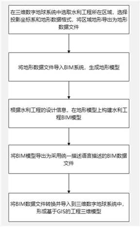
[0031] The technical solutions in the embodiments of the present invention will be clearly and completely described below, obviously, the described embodiments are only some of the embodiments of the present invention, not all of the embodiments. Based on the embodiments of the present invention, all other embodiments obtained by persons of ordinary skill in the art without making creative efforts belong to the protection scope of the present invention.

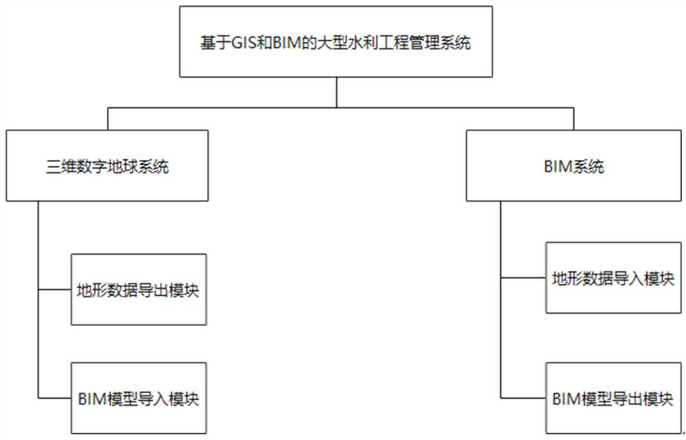
[0032] Such as figure 1 As shown, the large-scale water conservancy project management system based on GIS and BIM described in the present invention includes: a three-dimensional digital earth system and a BIM system,

[0033] The three-dimensional digital earth system has a terrain data export module and a BIM model import module, and supports cross-platform operation of various operating systems, such as Windows, Linux, Mac, Web, Android, IOS, etc.

[0034] The BIM system has a topographic data conversion plug-in, which i...


PUM


Abstract

The invention discloses a large-scale water conservancy project management method and system based on GIS and BIM, and the system comprises a three-dimensional digital earth system and a BIM system, and is characterized in that the three-dimensional digital earth system supports the cross-platform operation of a plurality of operation systems, and is provided with a topographic data export module and a BIM model import module; the BIM system supports various BIM software and is provided with a topographic data conversion plug-in, a topographic data import module and a BIM model export module. The method has the advantage that deep fusion of the GIS terrain and the BIM terrain can be realized. The high-precision topographic data are imported into the three-dimensional GIS system, BIM topographic data are directly obtained from the GIS system, and the BIM topographic data are processed and then returned to the GIS system, so that the consistency of the topographic data can be effectively guaranteed; in addition, the BIM topographic data can be converted into the standard topography of the three-dimensional GIS, and unified management of the three-dimensional GIS system is facilitated. According to the coordinate conversion method provided by the invention, accurate coordinate conversion of the long-distance water conveyance project can be met, and application of a GIS and BIM fusion technology can be deepened.

Description

technical field [0001] The invention relates to the field of water conservancy and hydropower engineering, in particular to a large-scale water conservancy project management method and system based on GIS and BIM. Background technique [0002] Water conservancy projects are generally system operations, involving many projects, large project scope, high difficulty in construction, and far-reaching environmental impact. It needs comprehensive use of GIS (Geographic Information System, Geographic Information System), BIM (Building Information Modeling, Building Information Model) and other information technologies to achieve Refined and intelligent management. [0003] GIS is a technical system that collects, stores, manages, calculates, analyzes, displays and describes relevant geospatial data in the entire or part of the earth's surface space with the support of computer software and hardware systems. [0004] BIM is a general term for the process and results of design, con...

Claims


Application Information

Patent Timeline
IPC IPC(8): G06Q50/06G06F30/13G06Q50/08G06T17/00G06T17/05
CPCG06Q50/06G06Q50/08G06F30/13G06T17/05G06T17/005
Inventor 安新代王军良张楠牛富敏彭少明
Owner YELLOW RIVER ENG CONSULTING
Why Eureka
Try Eureka