Point cloud spatial data processing method and device

A technology of spatial data and processing methods, applied in image data processing, electrical digital data processing, special data processing applications, etc., can solve the problems of inability to operate point cloud data, poor rendering efficiency of 3D point cloud information visualization, and massive point cloud data Insufficient capacity and other issues to achieve the effect of accelerating the construction process and improving production efficiency

Pending Publication Date: 2022-04-26
NORTH CHINA ELECTRICAL POWER RES INST +2
View PDF0 Cites 2 Cited by
  • Summary
  • Abstract
  • Description
  • Claims
  • Application Information

AI Technical Summary

Problems solved by technology

However, due to the bottleneck of computer hardware development (such as insufficient memory), the rendering efficiency of the 3D point cloud information visualization is poor, and at the same time, the ability to process massive point cloud data is insufficient (data structure algorithm), which seriously affects the massive point cloud data in actual projects. application, unable to operate on point cloud data more flexibly

Method used


Image

  • Point cloud spatial data processing method and device
  • Point cloud spatial data processing method and device
  • Point cloud spatial data processing method and device

Examples


Embodiment Construction

[0054]In order to make the purpose, technical solutions and advantages of the embodiments of the present invention clearer, the technical solutions in the embodiments of the present invention will be clearly and completely described below in conjunction with the drawings in the embodiments of the present invention. Obviously, the described embodiments It is a part of embodiments of the present invention, but not all embodiments. Based on the embodiments of the present invention, all other embodiments obtained by persons of ordinary skill in the art without creative efforts fall within the protection scope of the present invention.

[0055] Those skilled in the art should understand that the embodiments of the present invention may be provided as methods, systems, or computer program products. Accordingly, the present invention can take the form of an entirely hardware embodiment, an entirely software embodiment, or an embodiment combining software and hardware aspects. Furthe...


PUM


Abstract

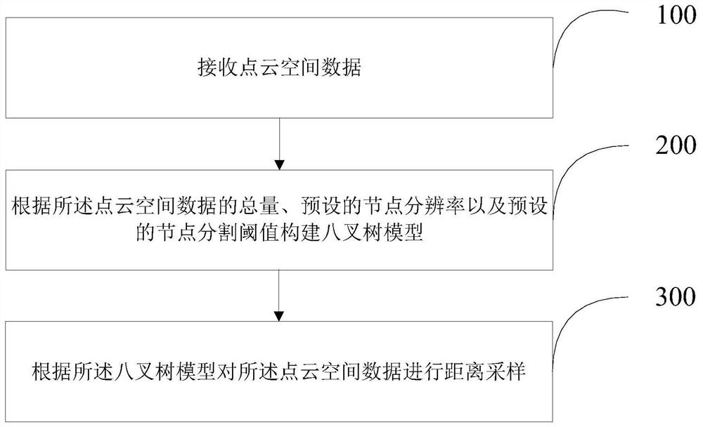
The invention provides a point cloud spatial data processing method and device. The point cloud spatial data processing method comprises the following steps: receiving point cloud spatial data; constructing an octree model according to the total amount of the point cloud spatial data, a preset node resolution and a preset node segmentation threshold; and carrying out distance sampling on the point cloud space data according to the octree model. According to the point cloud spatial data processing method and device provided by the invention, an octree structure is taken as a basis of a spatial data organization structure, a sampling process taking the node resolution as the interval is added in the octree construction process, and the finally constructed spatial data organization structure reserves a low-resolution point cloud data subset for low-level nodes, so that the point cloud data can be processed more accurately. The high-level nodes retain a high-resolution point cloud subset.

Description

technical field [0001] The invention relates to the technical field of electric power system and earth observation, in particular to the technical field of spatial data organization structure of airborne lidar point cloud data, and in particular to a processing method and device for point cloud spatial data. Background technique [0002] In recent years, the development of spatial information acquisition technologies such as 3D laser scanning, aerospace / terrestrial stereo photography image matching has become more and more mature, so that the acquisition of space object information has developed from 2D to 3D. Three-dimensional spatial information acquisition methods mainly include traditional measurement such as electromagnetic wave ranging, high-tech precision measuring instruments such as total stations, and three-dimensional laser scanning technology (LIDAR for short). Among them, LIDAR technology can divide the laser scanning system into airborne lidar system, vehicle-m...

Claims


Application Information

Patent Timeline
Patent Type & Authority Applications(China)
IPC IPC(8): G06T17/00G06T17/05G06T17/20G06F16/51G06F16/587G06F16/22G06F16/29G06F16/13
CPCG06T17/005G06T17/05G06T17/20G06F16/51G06F16/587G06F16/2246G06F16/2255G06F16/29G06F16/137G06T2210/36
Inventor 杜维柱张晓华蔡巍武宇平薛文祥卢毅于竞哲马鑫晟王书渊高岩峰王辉沈彦伶徐广达高静
Owner NORTH CHINA ELECTRICAL POWER RES INST
Why Eureka
Try Eureka